Rosenhayn, New Jersey
| Rosenhayn, New Jersey | |
|---|---|
| Census-designated place | |
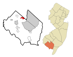 Map of Rosenhayn highlighted within Cumberland County. Right: Location of Cumberland County in New Jersey. | |
| Coordinates: 39°28′43″N 75°08′16″W / 39.47868°N 75.13791°WCoordinates: 39°28′43″N 75°08′16″W / 39.47868°N 75.13791°W | |
| Country |
|
| State |
|
| County | Cumberland |
| Township | Deerfield |
| Area[1] | |
| • Total | 2.654 sq mi (6.874 km2) |
| • Land | 2.654 sq mi (6.874 km2) |
| • Water | 0.000 sq mi (0.000 km2) 0.00% |
| Elevation[2] | 108 ft (33 m) |
| Population (2010 Census)[3] | |
| • Total | 1,098 |
| • Density | 413.7/sq mi (159.7/km2) |
| Time zone | Eastern (EST) (UTC-5) |
| • Summer (DST) | EDT (UTC-4) |
| ZIP code | 08352 |
| Area code(s) | 856 |
| FIPS code | 3464740[4] |
| GNIS feature ID | 02389778[5] |
Rosenhayn is an unincorporated community and census-designated place (CDP) located within Deerfield Township, in Cumberland County, New Jersey, United States.[6] It is part of the Vineland-Milleville- Bridgeton Primary Metropolitan Statistical Area for statistical purposes. As of the 2010 United States Census, the CDP's population was 1,098.[3]
Rosenhayn was founded as a Jewish agricultural colony and the 1898 Rosenhayn synagogue is one of the fewer than 100 surviving nineteenth century synagogue buildings in the United States.
Geography
According to the United States Census Bureau, the CDP had a total area of 2.654 square miles (6.874 km2), all land.[1][7]
Demographics
| Historical population | |||
|---|---|---|---|
| Census | Pop. | %± | |
| 1990 | 1,053 | — | |
| 2000 | 1,099 | 4.4% | |
| 2010 | 1,098 | −0.1% | |
| Population sources: 2000[8] 2010[3] | |||
Census 2010
The 2010 United States Census counted 1,098 people, 382 households, and 273.9 families residing in the CDP. The population density was 413.7 per square mile (159.7/km2). The CDP contained 404 housing units at an average density of 152.2 per square mile (58.8/km2). The racial makeup of the CDP was 64.21% (705) White, 18.03% (198) Black or African American, 1.28% (14) Native American, 1.46% (16) Asian, 0.00% (0) Pacific Islander, 9.29% (102) from other races, and 5.74% (63) from two or more races. Hispanics or Latinos of any race were 17.58% (193) of the population.[3]
Out of a total of 382 households, 34.8% had children under the age of 18 living with them, 51.0% were married couples living together, 16.2% had a female householder with no husband present, and 28.3% were non-families. 23.0% of all households were made up of individuals, and 10.5% had someone living alone who was 65 years of age or older. The average household size was 2.86 and the average family size was 3.36.[3]
In the CDP, 26.5% of the population were under the age of 18, 9.6% from 18 to 24, 24.8% from 25 to 44, 27.0% from 45 to 64, and 12.2% who were 65 years of age or older. The median age was 37.1 years. For every 100 females the census counted 98.2 males, but for 100 females at least 18 years old, it was 92.6 males.[3]
Census 2000
As of the 2000 United States Census[4] there were 1,099 people, 373 households, and 286 families residing in the CDP. The population density was 160.1/km2 (414.4/mi2). There were 393 housing units at an average density of 57.3/km2 (148.2/mi2). The racial makeup of the CDP was 70.43% White, 19.29% African American, 0.64% Native American, 0.18% Asian, 6.28% from other races, and 3.18% from two or more races. Hispanic or Latino of any race were 9.92% of the population.[8]
There were 373 households out of which 35.4% had children under the age of 18 living with them, 52.5% were married couples living together, 17.4% had a female householder with no husband present, and 23.1% were non-families. 17.7% of all households were made up of individuals and 7.8% had someone living alone who was 65 years of age or older. The average household size was 2.93 and the average family size was 3.29.[8]
In the CDP the population was spread out with 29.9% under the age of 18, 7.6% from 18 to 24, 27.8% from 25 to 44, 21.6% from 45 to 64, and 13.0% who were 65 years of age or older. The median age was 36 years. For every 100 females there were 94.2 males. For every 100 females age 18 and over, there were 93.5 males.[8]
The median income for a household in the CDP was $38,702, and the median income for a family was $38,155. Males had a median income of $33,092 versus $22,216 for females. The per capita income for the CDP was $14,801. About 12.2% of families and 15.7% of the population were below the poverty line, including 12.1% of those under age 18 and 25.2% of those age 65 or over.[8]
Notable people
People who were born in, residents of, or otherwise closely associated with Rosenhayn include:
References
- 1 2 Gazetteer of New Jersey Places, United States Census Bureau. Accessed July 21, 2016.
- ↑ U.S. Geological Survey Geographic Names Information System: Rosenhayn Census Designated Place, Geographic Names Information System. Accessed November 2, 2012.
- 1 2 3 4 5 6 DP-1 - Profile of General Population and Housing Characteristics: 2010 Demographic Profile Data for Rosenhayn CDP, New Jersey, United States Census Bureau. Accessed November 2, 2012.
- 1 2 American FactFinder, United States Census Bureau. Accessed September 4, 2014.
- ↑ US Board on Geographic Names, United States Geological Survey. Accessed September 4, 2014.
- ↑ Locality Search, State of New Jersey. Accessed April 19, 2015.
- ↑ US Gazetteer files: 2010, 2000, and 1990, United States Census Bureau. Accessed September 4, 2014.
- 1 2 3 4 5 DP-1 - Profile of General Demographic Characteristics: 2000 from the Census 2000 Summary File 1 (SF 1) 100-Percent Data for Rosenhayn CDP, New Jersey, United States Census Bureau. Accessed November 2, 2012.
- ↑ Siegman, Joseph. "Jewish Sports Legends: The International Jewish Hall of Fame", p. 59. Brassey's, 2000. ISBN 9781574882841. Accessed December 29, 2007.