Roughedge, North Carolina
| Roughedge | |
|---|---|
| Unincorporated community | |
 Roughedge Location within the state of North Carolina | |
| Coordinates: 34°53′58″N 80°37′25″W / 34.89944°N 80.62361°WCoordinates: 34°53′58″N 80°37′25″W / 34.89944°N 80.62361°W | |
| Country | United States |
| State | North Carolina |
| County | Union County |
| Elevation | 705 ft (215 m) |
| Time zone | Eastern (EST) (UTC-5) |
| • Summer (DST) | EDT (UTC-4) |
| ZIP code | 28112 |
| Area code(s) | 704, 980 |
| GNIS feature ID | 1022407[1] |
Roughedge is an unincorporated community in Union County, North Carolina, United States. It is located southwest of Monroe, at the intersection of NC 200 (Lancaster Highway) and NC 522 (Rocky River Road).
References
Municipalities and communities of Union County, North Carolina, United States | ||
|---|---|---|
| City | 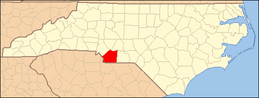 | |
| Towns | ||
| Villages | ||
| CDP | ||
| Unincorporated communities | ||
| Ghost town | ||
| Footnotes | ‡This populated place also has portions in an adjacent county or counties | |
This article is issued from Wikipedia - version of the 3/23/2014. The text is available under the Creative Commons Attribution/Share Alike but additional terms may apply for the media files.