Routhierville, Quebec
| Routhierville | |
|---|---|
| Unorganized territory | |
 | |
 Location within La Matapédia RCM. | |
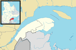 Routhierville Location in eastern Quebec. | |
| Coordinates: 48°11′N 67°09′W / 48.183°N 67.150°WCoordinates: 48°11′N 67°09′W / 48.183°N 67.150°W[1] | |
| Country |
|
| Province |
|
| Region | Bas-Saint-Laurent |
| RCM | La Matapédia |
| Constituted | unspecified |
| Government[2] | |
| • Federal riding |
Haute-Gaspésie—La Mitis—Matane—Matapédia |
| • Prov. riding | Matane-Matapédia |
| Area[2][3] | |
| • Total | 625.80 km2 (241.62 sq mi) |
| • Land | 628.55 km2 (242.68 sq mi) |
|
There is an apparent contradiction between two authoritative sources | |
| Population (2011)[3] | |
| • Total | 15 |
| • Density | 0.0/km2 (0/sq mi) |
| • Pop 2006-2011 |
|
| • Dwellings | 15 |
| Time zone | EST (UTC-5) |
| • Summer (DST) | EDT (UTC-4) |
| Area code(s) | 418 and 581 |
| Highways |
|
Routhierville is an unorganized territory in the Bas-Saint-Laurent region of Quebec, Canada. The territory is bisected by the Matapédia River and Quebec Route 132 that runs parallel to it. There are two hamlets in the territory: the eponymous Routhierville (48°10′57″N 67°08′57″W / 48.18250°N 67.14917°W) and Milnikek (48°08′21″N 67°09′11″W / 48.13917°N 67.15306°W).
The community of Routhierville is located on the west bank of the Matapédia River along the Canadian National Railway that was originally constructed as the Intercolonial Railway in the 1860s, while its train station was built in 1878. The community used to be called Assametquagan, meaning "appearing at the detour", but renamed after station master Alphonse Routhier (1875-1958).[4][5]
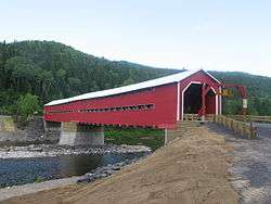
The community of Routhierville is accessible from Route 132 with a covered bridge over the Matapédia River, built in 1931 to replace a ferry. This 78.5 metres (258 ft) long and 6.3 metres (21 ft) wide bridge was classified as a historic monument on October 1, 2009, and rebuilt in 2011.[5]
Demographics
Population trend:[6]
- Population in 2011: 15 (2006 to 2011 population change: 200.0%)
- Population in 2006: 5
- Population in 2001: 25
- Population in 1996: 24
- Population in 1991: 40
Private dwellings occupied by usual residents: 8 (total dwellings: 15)
Notable People
- Jean Brillant - Routhierville born recipient of the Victoria Cross for actions during the Battle of Amiens during the First World War
Gallery
.jpg) Routhierville bridge before refurbishing
Routhierville bridge before refurbishing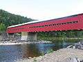 Routhierville bridge today
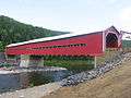 Routhierville bridge today
 Routhierville bridge before
 Routhierville bridge before
See also
References
- ↑ Reference number 149679 of the Commission de toponymie du Québec (French)
- 1 2 "Routhierville". Répertoire des municipalités (in French). Ministère des Affaires municipales, des Régions et de l'Occupation du territoire. Retrieved 2012-02-06.
- 1 2 "Routhierville census profile". 2011 Census data. Statistics Canada. Retrieved 2012-02-06.
- ↑ "Routhierville description". Info Gaspésie. Retrieved 2012-02-06.
- 1 2 "Pont couvert de Routhierville" (in French). Commission de toponymie du Québec. Retrieved 2012-02-06.
- ↑ Statistics Canada: 1996, 2001, 2006, 2011 census
| Wikimedia Commons has media related to Routhierville. |
 |
Rivière-Vaseuse | Sainte-Florence / Sainte-Marguerite-Marie | Lac-Casault | |
| Ruisseau-Ferguson | |
Rivière-Nouvelle | ||
| ||||
| | ||||
| Saint-François-d'Assise / Saint-André-de-Restigouche | Pointe-à-la-Croix |
| Cities & Towns | |
|---|---|
| Municipalities | |
| Parishes | |
| Villages | |
| Unorganized territories | |
| |