Ruggles Park
|
Ruggles Park | |
 | |
  | |
| Location | Fall River, Massachusetts |
|---|---|
| Coordinates | 41°42′14″N 71°8′46″W / 41.70389°N 71.14611°WCoordinates: 41°42′14″N 71°8′46″W / 41.70389°N 71.14611°W |
| Area | 9 acres |
| Built | 1868 |
| Architect | Olmsted Brothers |
| MPS | Fall River MRA |
| NRHP Reference # | [1] |
| Added to NRHP | February 16, 1983 |
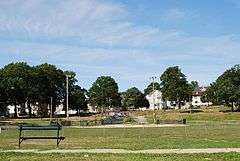
Ruggles Park is a park in Fall River, Massachusetts. It covers about 9 acres within a densely populated working-class neighborhood bounded by Seabury, Robeson, Pine, and Locust Streets, just north of the Granite Mills.
The land for park was originally part of the Rodman Farm. In 1868, the city purchased 15 acres (6.1 ha) that included a fine natural plantation known as Ruggles Grove. It was redesigned in 1903 by the Olmsted Brothers.[2]
It is one of three Olmsted parks in the city, along with Kennedy Park (originally known as South Park) and North Park (part of the Highlands Historic District).
Ruggles Park was added to the National Register of Historic Places in 1983.
See also
References
- ↑ National Park Service (2008-04-15). "National Register Information System". National Register of Historic Places. National Park Service.
- ↑ MHC Inventory Form
| Topics |  | ||||||||||||||||||||||||||||||
|---|---|---|---|---|---|---|---|---|---|---|---|---|---|---|---|---|---|---|---|---|---|---|---|---|---|---|---|---|---|---|---|
| Lists by county | |||||||||||||||||||||||||||||||
| Lists by city |
| ||||||||||||||||||||||||||||||
| Other lists | |||||||||||||||||||||||||||||||
| |||||||||||||||||||||||||||||||
This article is issued from Wikipedia - version of the 11/27/2016. The text is available under the Creative Commons Attribution/Share Alike but additional terms may apply for the media files.