Russellville, Ohio
| Russellville, Ohio | |
|---|---|
| Village | |
 Location of Russellville, Ohio | |
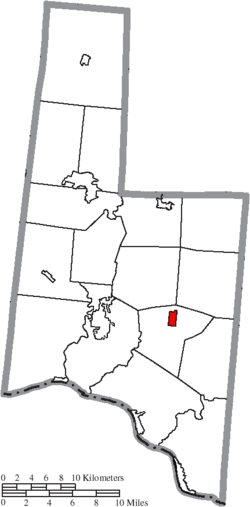 Location of Russellville in Brown County | |
| Coordinates: 38°52′6″N 83°47′15″W / 38.86833°N 83.78750°WCoordinates: 38°52′6″N 83°47′15″W / 38.86833°N 83.78750°W | |
| Country | United States |
| State | Ohio |
| County | Brown |
| Township | Jefferson |
| Area[1] | |
| • Total | 0.73 sq mi (1.89 km2) |
| • Land | 0.73 sq mi (1.89 km2) |
| • Water | 0 sq mi (0 km2) |
| Elevation[2] | 961 ft (293 m) |
| Population (2010)[3] | |
| • Total | 561 |
| • Estimate (2012[4]) | 552 |
| • Density | 768.5/sq mi (296.7/km2) |
| Time zone | Eastern (EST) (UTC-5) |
| • Summer (DST) | EDT (UTC-4) |
| ZIP code | 45168 |
| Area code(s) | 937 |
| FIPS code | 39-69316[5] |
| GNIS feature ID | 1065263[2] |
Russellville is a village in Brown County, Ohio, United States. The population was 561 at the 2010 census.
History
Russellville was laid out in 1817 by Russell Shaw, and named for him.[6]
Gallery
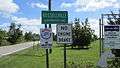 Russellville corporation limit sign.
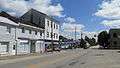 Looking east at the intersection of Main Street (Ohio Highway 125) and Columbus Street (US Highway 62) in Russellville.
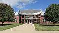 Russellville Elementary School.
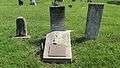 Grave of Russell Shaw, the founder of Russellville, in Shaw Cemetery.
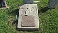 Grave of Russell Shaw.
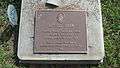 Grave of Russell Shaw.
Geography
Russellville is located at 38°52′6″N 83°47′15″W / 38.86833°N 83.78750°W (38.868338, -83.787610).[7]
According to the United States Census Bureau, the village has a total area of 0.73 square miles (1.89 km2), all land.[1]
Demographics
| Historical population | |||
|---|---|---|---|
| Census | Pop. | %± | |
| 1850 | 386 | — | |
| 1860 | 465 | 20.5% | |
| 1870 | 359 | −22.8% | |
| 1880 | 478 | 33.1% | |
| 1890 | 324 | −32.2% | |
| 1900 | 394 | 21.6% | |
| 1910 | 438 | 11.2% | |
| 1920 | 435 | −0.7% | |
| 1930 | 411 | −5.5% | |
| 1940 | 452 | 10.0% | |
| 1950 | 438 | −3.1% | |
| 1960 | 412 | −5.9% | |
| 1970 | 399 | −3.2% | |
| 1980 | 445 | 11.5% | |
| 1990 | 459 | 3.1% | |
| 2000 | 453 | −1.3% | |
| 2010 | 561 | 23.8% | |
| Est. 2015 | 543 | [8] | −3.2% |
Russellville Elementary School, the only school in the village, has approximately 480 pupils and 28 full-time staff.
2010 census
As of the census[3] of 2010, there were 561 people, 209 households, and 139 families residing in the village. The population density was 768.5 inhabitants per square mile (296.7/km2). There were 236 housing units at an average density of 323.3 per square mile (124.8/km2). The racial makeup of the village was 99.1% White, 0.5% African American, and 0.4% from two or more races. Hispanic or Latino of any race were 0.5% of the population.
There were 209 households of which 40.7% had children under the age of 18 living with them, 48.3% were married couples living together, 14.4% had a female householder with no husband present, 3.8% had a male householder with no wife present, and 33.5% were non-families. 25.8% of all households were made up of individuals and 12.4% had someone living alone who was 65 years of age or older. The average household size was 2.68 and the average family size was 3.28.
The median age in the village was 33.7 years. 30.3% of residents were under the age of 18; 7.8% were between the ages of 18 and 24; 27.3% were from 25 to 44; 20.8% were from 45 to 64; and 13.9% were 65 years of age or older. The gender makeup of the village was 48.1% male and 51.9% female.
2000 census
As of the census[5] of 2000, there were 453 people, 190 households, and 121 families residing in the village. The population density was 582.2 people per square mile (224.2/km²). There were 215 housing units at an average density of 276.3 per square mile (106.4/km²). The racial makeup of the village was 98.68% White, 0.88% African American, and 0.44% from two or more races. Hispanic or Latino of any race were 1.10% of the population.
There were 190 households out of which 27.9% had children under the age of 18 living with them, 50.0% were married couples living together, 9.5% had a female householder with no husband present, and 35.8% were non-families. 32.1% of all households were made up of individuals and 19.5% had someone living alone who was 65 years of age or older. The average household size was 2.35 and the average family size was 2.98.
In the village the population was spread out with 25.8% under the age of 18, 7.1% from 18 to 24, 25.4% from 25 to 44, 21.4% from 45 to 64, and 20.3% who were 65 years of age or older. The median age was 38 years. For every 100 females there were 84.1 males. For every 100 females age 18 and over, there were 84.6 males.
The median income for a household in the village was $30,000, and the median income for a family was $38,594. Males had a median income of $26,875 versus $21,250 for females. The per capita income for the village was $15,010. About 4.5% of families and 7.0% of the population were below the poverty line, including 3.4% of those under age 18 and 10.8% of those age 65 or over.
Notable person
Mills Gardner, attorney and Ohio congressman, was born in Russellville.[10]
References
- 1 2 "US Gazetteer files 2010". United States Census Bureau. Retrieved 2013-01-06.
- 1 2 "US Board on Geographic Names". United States Geological Survey. 2007-10-25. Retrieved 2008-01-31.
- 1 2 "American FactFinder". United States Census Bureau. Retrieved 2013-01-06.
- ↑ "Population Estimates". United States Census Bureau. Retrieved 2013-06-17.
- 1 2 "American FactFinder". United States Census Bureau. Retrieved 2008-01-31.
- ↑ The History of Brown County, Ohio. Higginson Book Company. 1883. p. 620.
- ↑ "US Gazetteer files: 2010, 2000, and 1990". United States Census Bureau. 2011-02-12. Retrieved 2011-04-23.
- ↑ "Annual Estimates of the Resident Population for Incorporated Places: April 1, 2010 to July 1, 2015". Retrieved July 2, 2016.
- ↑ "Census of Population and Housing". Census.gov. Retrieved June 4, 2015.
- ↑ Allen, Frank M. (1914). History of Fayette County, Ohio. B. F. Bowen, Inc. p. 720.
Municipalities and communities of Brown County, Ohio, United States | ||
|---|---|---|
| Villages | 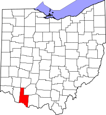 | |
| Townships | ||
| CDPs | ||
| Unincorporated communities | ||
| Footnotes | ‡This populated place also has portions in an adjacent county or counties | |