Saanich, British Columbia
| Saanich W̱SÁNEĆ | ||
|---|---|---|
| District municipality | ||
| The Corporation of the District of Saanich[1] | ||
|
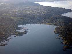
Aerial of Saanich, with Cadboro Bay in the foreground | ||
| ||
_location_map.svg.png) Saanich Location of Saanich within British Columbia | ||
| Coordinates: 48°29′02″N 123°22′52″W / 48.484°N 123.381°W | ||
| Country | Canada | |
| Province | British Columbia | |
| Regional District | Capital | |
| Incorporated | 1906 | |
| Government | ||
| • Mayor | Richard Atwell | |
| • Governing body | Saanich Council | |
| • MP |
List of MPs
| |
| • MLA |
List of MLAs
| |
| Area | ||
| • Total | 103.44 km2 (39.94 sq mi) | |
| Elevation | 23 m (75 ft) | |
| Population (2011)[2] | ||
| • Total | 109,752 | |
| • Density | 1,057.6/km2 (2,739/sq mi) | |
| Time zone | PST (UTC−8) | |
| • Summer (DST) | PDT (UTC−7) | |
| Postal code span | V8N-V8Z | |
| Area code(s) | 250, 778 & 236 | |
| Website | www.saanich.ca/ | |

The District of Saanich (/sænɪtʃ/) is a district municipality on Vancouver Island in British Columbia, within the Greater Victoria area. The population was 109,752 at the 2011 census, making it the most populous municipality in the Capital Regional District and Vancouver Island, and the eighth-most populous in the province.[3] The district adopted its name after the Saanich First Nation, meaning "emerging land" or "emerging people".[4]
The Municipality of Saanich was incorporated on March 1, 1906. With an area of 103.44 square kilometres (39.94 sq mi), it is the largest of the core municipalities making up Greater Victoria. The topography is undulating with many glacially scoured rock outcroppings. Elevations range from sea level to 229 metres (751 ft). The physical setting is greatly influenced by water. There are 8.1749 square kilometres (3.1563 sq mi) of fresh water lakes and 29.61 kilometres (18.40 mi) of marine shoreline.
Saanich is home to part of the University of Victoria which is bisected by the boundary with the neighbouring district municipality of Oak Bay. Saanich is fairly large in area and contains a wide variety of rural and urban landscapes and neighbourhoods stretching north to the Saanich Peninsula. Saanich is the location of the Dominion Astrophysical Observatory near Elk Lake. The District of Saanich contains a long shoreline with sandy beaches located at a number of ocean bays. Two of the beaches are Cadboro Bay Beach and Cordova Bay Beach. Cadboro Bay is known as a place to view the "Cadborosaurus", a mythical sea monster that may or may not exist. Saanich's notable parks include Mount Douglas Park, Mount Tolmie Park (with viewpoints) and Gyro Park.
Communities of Saanich
Saanich consists of 18 communities[5] recognized by the municipal government. These communities were originally created to collect and provide input into land use within those areas. However, over the years many community associations have expanded the scope of their activities beyond land use issues.
- Cordova Bay Association for Community Affairs
- Quadra/Cedar Hill Community Association
- Falaise Community Association
- Rainbow Park Ratepayers Association
- Broadmead Area Residents Association
- Mount View Colquitz Community Association
- Gorge Tillicum Community Association
- Blenkinsop Valley Community Association
- Portage Inlet Sanctuary Colquitz Estuary Society (PISCES)
- Gordon Head Residents' Association
- Strawberry Vale Residents' Association
- Residents Association of Strawberry Vale, Marigold and Glanford
- Cadboro Bay Residents Association
- North Quadra Land-use Protection Association
- Mount Tolmie Community Association
- Royal Oak Community Association
- Camosun Community Association
- Prospect Lake and District Community Association
Neighbourhoods of Saanich
The Victoria Real Estate Board divides the District of Saanich along the Patricia Bay Highway into two broad areas: Saanich East and Saanich West.[6] Both of these areas contain a number of distinct shopping areas or communities.
Saanich East
The Saanich neighbourhoods located east of the Patricia Bay Highway include:
- Broadmead - Located east of the Patricia Bay Highway south of Cordova Bay and north of Mount Douglas Park. An upscale master planned community with contemporary west coast architecture in a wooded setting. Broadmead Village is the commercial shopping core for residents. The neighbouring area of Sunnymead is sometimes referred to in conjunction with Broadmead itself. The area was originally developed by the famous Guinness family, who also developed the British Properties in West Vancouver.
- Cadboro Bay - A scenic residential area east of the University of Victoria and just north of the Oak Bay border. Cadboro Bay itself has a popular park with a sandy beach (including concrete octopus and sea monster Cadborosaurus), and a charming village shopping area.
- Cedar Hill - A middle-class, largely older residential area just south of Mount Douglas (formerly Cedar Hill), bounded by Quadra St., Cook St., Finlayson St. - North Dairy Rd., Shelbourne St., and McKenzie Ave. Dominated by the Cedar Hill Golf Course.
- Cloverdale - In the southwest corner of the municipality, bounded by Tolmie Ave., Douglas St., Saanich Rd., Tattersall Dr., Quadra St., and Cook St. To the south and west is a heavily built-up commercial area, transitioning in areas to industrial zones. Low-rise apartment buildings predominate in sections, with further commercial development along Cook and Quadra Streets. The rest is a diverse mix of middle- and lower-middle-class homes, including some subsidized housing. Cloverdale Ave. (named for a pioneer farm) runs through the centre of the neighbourhood.
- Cordova Bay - A mixed rural and residential area of newer and older homes, situated east of Elk and Beaver Lakes and north of Broadmead. It is an upper-middle-class area and includes a small "village-like" strip along scenic Cordova Bay Road. It also hosts its own youth soccer club, titled Cordova Bay Soccer Association.
- Gordon Head - Gordon Head is a seaside neighbourhood. Gordon Head lies north of McKenzie Avenue and east of the Blenkinsop Valley. The University of Victoria is located partly within Gordon Head along the south-east boundary. Finnerty Road separates Gordon Head from the adjacent neighbourhood of Cadboro Bay. The local area is dominated physically by Mt. Douglas, a coastline along Haro Strait, and the central plateau.
- Lake Hill - Located south of Broadmead, north of McKenzie Avenue, east of the Pat Bay Highway, and west of Borden Road. This is a neighbourhood of mainly postwar lower-middle-class- and middle-class homes with larger infill housing from the 1970s and 1980s. It includes the Christmas Hill Nature Sanctuary.
- Maplewood is west of the Cedar Hill golf course, with borders of Quadra Street on the west, McKenzie Avenue on the north, Maplewood- Blenkinsop Road on the east and Cook Street. It is an older, treed area with many character homes and winding streets. There is a "star" intersection located at Camrose Crescent, Crown Crescent, and Salsbury Way. Maplewood contains many older residences of historical significance: Brown, Clovelly, Duke, French, Holland, Kitchin, Rockside and Wayne residences.[7]
- Mt. Douglas - The area surrounding Mount Douglas, west of Shelbourne Street and Cedar Hill Road, north of McKenzie Avenue, east of Blenkinsop Road, and bounded to the north by Haro Strait and Cordova Bay Road. The most prominent feature of this area is the mountain itself and the surrounding Mount Douglas Park, which includes a lookout near the summit of the mountain with an impressive view of Greater Victoria.
- Mt. Tolmie - Bounded to the west and south by the Victoria border, along Shelbourne St. and Richmond Rd., to the east by the Oak Bay border, along Foul Bay Road, and to the north by Cedar Hill Cross Rd. This area contains the Lansdowne Campus of Camosun College, St. Michael's University School, the northern pavilions of Royal Jubilee Hospital, and of course the panoramic Mt. Tolmie itself. A mixture of commercial establishments and low-rise apartment blocks lie along the western and southern extremities, and middle-class homes farther east.
- North Quadra - A nearly exclusively suburban area, predominated by single-family homes, and bounded on the south by McKenzie Avenue, the west by the Pat Bay Highway, and the east by the Blenkinsop Valley. Only at the southern margins, along McKenzie, is there any commercial activity and a few apartment blocks. The area is dominated by Christmas Hill, the summit of which is part of the Swan Lake Christmas Hill Nature Sanctuary (the lake and the hill are only connected by a narrow footpath, but are administered by the same society). The area is also home to Rogers and Lakehill Elementary (Lakehill being the former name of Christmas Hill, with its prominent views of Swan and Blenkinsop lakes - the latter actually being earlier called "Lost Lake").
- Queenswood is a wooded, seaside neighbourhood located north of Cadboro Bay and northwest of Ten Mile Point. Originally developed in the 1940s, Queenswood is characterized by winding roads and secluded character homes on large, treed estates. Immediately west of Queenswood are the 14-acre (57,000 m2) wooded lands containing the former Queenswood Centre for Spiritual Development, now owned by the University of Victoria.
- Royal Oak - Sits between Broadmead (East of Patricia Bay Highway) and View Royal (West of Highway #1)
- Swan Lake - Lying south of McKenzie, east of the Patricia Bay Highway, north of Tattersall Dr., and west of Quadra St. A pleasant, treed area of older middle-class homes, at the centre of which is Swan Lake Nature Sanctuary.
- Ten Mile Point is the most easterly point on Vancouver Island. This wooded upper-class area is located east of Cadboro Bay and the University of Victoria. Ten Mile Point is an exclusive, expensive, peninsular neighbourhood known for its secluded beaches, private estates and waterfront properties. While Ten Mile Point is located within the urban part of Saanich, its setting has a quiet, rural feel.
Saanich West
The Saanich neighbourhoods located west of the Patricia Bay Highway include:
- Beaver Lake-Elk Lake - A rural area just south of the Central Saanich border, bounded by Old West Saanich Road and the Patricia Bay Highway, dominated by Beaver and Elk Lakes, and Bear Hill Regional Park.
- Glanford - A mix of all kinds of residential homes. Located between Carey Rd., Patricia Bay Highway, and Vanalman Rd. It is named for the central thoroughfare of the neighbourhood, Glanford Ave.
- Gorge-Tillicum - A mix of lower-middle- and middle-class homes, as well as mixed industrial and commercial neighbourhoods, bounded to the northwest by Portage Inlet, to the southwest by the picturesque Gorge waterway (a narrow channel leading from Selkirk Water to Portage Inlet), to the east by Interurban and West Burnside Roads, to the north by the Trans-Canada Highway, and to the southeast by the border with Victoria, running along Harriet Road. This area has shown evidence of gentrification as homes are being renovated and upgraded.
- Interurban - A largely rural area, with some considerable wooded areas still remaining, located to the east and west of Interurban Road. Newer subdivisions are creeping in, but much of the agricultural land is protected. The neighbourhood, lying west of Wilkinson Road and south of West Saanich Road, is home to the Interurban Campus of Camosun College, the Vancouver Island Technology Park (a light industrial park), and the historic Wilkinson Road Jail, a provincial maximum security jail housing sentenced and remanded inmates. Jail was designed by Architect Col William Ridgway Wilson.
- Marigold - Bounded by West Burnside Rd., McKenzie Ave., Carey Rd., and Wilkinson Rd. Some farmland, notably "Panama Flats" remains undeveloped because it has been designated a protected parkland. This is part of an extensive greenbelt which also includes the famous Galloping Goose trail. The bird watcher may have a field day here, as the flats provide home to many types of water fowl, hawks and songbirds. The Marigold area is being developed extensively and no longer has many post-war homes. There are many new neighbourhoods and luckily, they have been developed with respect for the multitude of wildlife found here. "Marigold" is one of many "flower-themed" roads in the neighbourhood.
- Prospect Lake - A largely rural and wooded area, with some newer subdivisions, in the northwest of the municipality. It lies just east of the Highlands municipal boundary. It contains a number of wooded parks (notably Prospect Lake and Francis/King).
- Strawberry Vale - Bounded by Wilkinson Rd., View Royal, and the Layritz Park area. An area in transition, it is a mix of small farms, older subdivisions, and newer subdivisions.
- Tillicum Village anchored by Tillicum Mall, built on the former site of the Tillicum Outdoor Theatre, (Old Navy, London Drugs, and Home Outfitters) and the Silver City Movie Theatre Complex, this developing village area is also home the George R. Pearkes Recreation Center and the Saanich Centennial Library. This commercial area also has a collection of small locally owned businesses and restaurants in nearby Burnside Plaza.
- Uptown - A largely commercial and industrial zone in the southwest corner of Saanich, next to the Victoria border, between Blanshard St., Burnside Rd., and Tillicum Rd. Residentially, it contains mainly small, post-war, lower-middle-class housing, and low-rise apartments, although many new developments have been built in the area since the redevelopment of Town and Country mall. The municipal hall and two large shopping centres - Mayfair and Uptown - are located in this area.
- Westview Heights - A classic 1950s residential subdivision bounded by Interurban Road, Tillicum Road and Carey Road. This area was planned by Gordon Rolston, who was also the planner for the development of Broadmead. Common traits of the area with Broadmead include sloping landscaping, integration of natural features with the residential development, and the construction of quality middle-class homes. The land was originally owned by William Rowland, and is known for its clear views of the Olympic Mountains and the Sooke Hills.
Climate
| Climate data for Victoria Phyllis Street, British Columbia (1971-2000) | |||||||||||||
|---|---|---|---|---|---|---|---|---|---|---|---|---|---|
| Month | Jan | Feb | Mar | Apr | May | Jun | Jul | Aug | Sep | Oct | Nov | Dec | Year |
| Record high °C (°F) | 14.5 (58.1) |
15.0 (59) |
18.5 (65.3) |
22.0 (71.6) |
27.5 (81.5) |
30.5 (86.9) |
28.5 (83.3) |
29.5 (85.1) |
27.5 (81.5) |
23.0 (73.4) |
16.1 (61) |
15.0 (59) |
30.5 (86.9) |
| Average high °C (°F) | 7.2 (45) |
8.2 (46.8) |
10.2 (50.4) |
12.8 (55) |
15.6 (60.1) |
18.2 (64.8) |
20.1 (68.2) |
20.1 (68.2) |
17.5 (63.5) |
13.2 (55.8) |
9.4 (48.9) |
7.4 (45.3) |
13.33 (56) |
| Daily mean °C (°F) | 5.5 (41.9) |
6.1 (43) |
7.5 (45.5) |
9.5 (49.1) |
11.9 (53.4) |
14.2 (57.6) |
15.7 (60.3) |
15.8 (60.4) |
13.9 (57) |
10.6 (51.1) |
7.5 (45.5) |
5.7 (42.3) |
10.33 (50.59) |
| Average low °C (°F) | 3.7 (38.7) |
4.0 (39.2) |
4.8 (40.6) |
6.2 (43.2) |
8.1 (46.6) |
10.1 (50.2) |
11.3 (52.3) |
11.4 (52.5) |
10.1 (50.2) |
8.0 (46.4) |
5.6 (42.1) |
4.0 (39.2) |
7.28 (45.1) |
| Record low °C (°F) | −8.0 (17.6) |
−11.0 (12.2) |
−4.0 (24.8) |
0.6 (33.1) |
3.0 (37.4) |
5.6 (42.1) |
8.0 (46.4) |
7.0 (44.6) |
5.0 (41) |
−2.0 (28.4) |
−10.5 (13.1) |
−10.0 (14) |
−11 (12.2) |
| Average precipitation mm (inches) | 102.2 (4.024) |
76.7 (3.02) |
51.5 (2.028) |
36.1 (1.421) |
34.2 (1.346) |
25.5 (1.004) |
16.1 (0.634) |
23.8 (0.937) |
25.9 (1.02) |
66.9 (2.634) |
130.8 (5.15) |
109.2 (4.299) |
698.9 (27.517) |
| Average rainfall mm (inches) | 99.4 (3.913) |
72.7 (2.862) |
50.9 (2.004) |
36.1 (1.421) |
34.2 (1.346) |
25.5 (1.004) |
16.1 (0.634) |
23.8 (0.937) |
25.9 (1.02) |
66.7 (2.626) |
129.0 (5.079) |
105.8 (4.165) |
686.1 (27.011) |
| Average snowfall cm (inches) | 2.8 (1.1) |
4.0 (1.57) |
0.2 (0.08) |
0.0 (0) |
0.0 (0) |
0.0 (0) |
0.0 (0) |
0.0 (0) |
0.0 (0) |
0.2 (0.08) |
1.9 (0.75) |
3.4 (1.34) |
12.5 (4.92) |
| Average precipitation days (≥ 0.2 mm) | 17.0 | 15.2 | 15.0 | 12.2 | 10.9 | 8.9 | 6.1 | 5.9 | 7.3 | 13.6 | 19.0 | 18.3 | 149.4 |
| Average rainy days (≥ 0.2 mm) | 16.7 | 14.9 | 15.0 | 12.2 | 10.9 | 8.9 | 6.1 | 5.9 | 7.3 | 13.6 | 18.8 | 17.7 | 148 |
| Average snowy days (≥ 0.2 cm) | 0.88 | 1.0 | 0.11 | 0.0 | 0.0 | 0.0 | 0.0 | 0.0 | 0.0 | 0.07 | 0.39 | 0.96 | 3.41 |
| Source: Environment Canada[8] | |||||||||||||
History
Saanich has been the home to First Nations people for thousands of years. The non-native history begins with the arrival of the Hudson's Bay Company in the 1840s.
The Craigflower Schoolhouse (originally called Maple Point School), the oldest surviving school building in Western Canada, was built on orders from Kenneth MacKenzie. He came from Scotland with his family in 1852, on the Hudson's Bay Company ship Norman Morison, to establish a farm for the Puget Sound Agricultural Company, a subsidiary of the Hudson's Bay Company. A school was needed for the children of farm employees, as well as those of arriving settlers.
The Dominion Astrophysical Observatory telescope was designed by Dr John Stanley Plaskett, astronomer with the Department of the Interior in Ottawa. The 72 inch (1.8 m) reflecting telescope was the largest of its kind in the world when it was built, though this was only the case for a few short months in 1918.
Education
The northeastern half of British Columbia's third largest university, the University of Victoria campus, is in Saanich, while the southwestern portion is in neighbouring Oak Bay. Saanich is also home to both major campuses of Camosun College, the original Lansdowne campus which is also divided between Saanich and Oak Bay and the Interurban campus.
Saanich is divided between two bordering school districts, School District 61 Greater Victoria and School District 63 Saanich. It is also the home of South Island Distance Education School.
Demographics
(according to Statistics Canada 2001 census) Growth rate (1996 to 2001): 2.2% Total private Dwellings: 42,905 Area: 103.45 square kilometres (39.94 sq mi) Density: 1,002.2 people/km2, 2,595.7 people/sq mi
Surrounding municipalities and communities

References
- ↑ "British Columbia Regional Districts, Municipalities, Corporate Name, Date of Incorporation and Postal Address" (XLS). British Columbia Ministry of Communities, Sport and Cultural Development. Retrieved November 2, 2014.
- ↑
- ↑
- ↑ http://www.firstvoices.ca/scripts/WebObjects.exe/FirstVoices.woa/3/wa/enterLanguageArchive?archive=3c39bcf779c644e3&wosid=WZ91RL9KfCr5EAIGt5ucig
- ↑ http://www.saanich.ca/living/associations.html
- ↑ Saanich West
- ↑ "The Canadian Register". Canada's Historic Places. Retrieved February 24, 2014.
- ↑ "Canadian Climate Normals 1971-2000". Government of Canada. Retrieved 19 May 2016.
External links
| Wikimedia Commons has media related to Saanich, British Columbia. |
| Subdivisions | 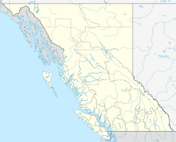 | |
|---|---|---|
| Communities | ||
| Metro areas and agglomerations | ||
| District municipalities |
| |
| ||