Sackville, New Brunswick
| Sackville | ||
|---|---|---|
| Town | ||
|
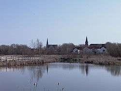
Sackville Waterfowl Park | ||
| ||
| Motto: The place You Belong | ||
 Sackville | ||
| Coordinates: 45°53′53″N 64°22′06″W / 45.89792°N 64.36834°W | ||
| Country | Canada | |
| Province | New Brunswick | |
| County | Westmorland | |
| Parish | Sackville Parish | |
| Established | 1762 | |
| Incorporated | January 4, 1903 | |
| Federal electoral district | Beauséjour | |
| Provincial electoral district | Memramcook-Tantramar | |
| Government | ||
| • Type | Town Council | |
| • Mayor | John Higham | |
| • MLA | Bernard LeBlanc Liberal Party of New Brunswick | |
| • MP | Dominic LeBlanc (L) | |
| Area | ||
| • Total | 74.32 km2 (28.70 sq mi) | |
| Elevation | Sea level to 32 m (0 to 105 ft) | |
| Population (2011) | ||
| • Total | 5,558 | |
| • Density | 74.8/km2 (194/sq mi) | |
| Demonym(s) | Sackvillian | |
| Time zone | Atlantic (AST) (UTC-4) | |
| • Summer (DST) | ADT (UTC-3) | |
| Canadian Postal code | E4L | |
| Area code(s) | 506 | |
| Telephone Exchange | 364, 536, 939 | |
| NTS Map | 021H16 | |
| GNBC Code | DAEAM | |
| Website |
www | |
Sackville is a town in southeastern New Brunswick, Canada. It is home to Mount Allison University, a primarily undergraduate liberal arts university. Historically home to two foundries manufacturing stoves and furnaces, the economy is now driven by the university and tourism. Once a part of the French colony, it became part of the British colony in 1755 following the Expulsion of the Acadians.
History
Pre-European
Present-day Sackville is in the former Mi’kmaq district of Siknikt (to which the place name Chignecto may be traced), which roughly comprised Cumberland, Westmorland and part of Albert counties. The Mi’kmaq settlement, Goesomaligeg, was on Fort Beausejour Ridge and Tatamalg or Tantama, on the Sackville Ridge. Many regional toponyms are Mi’kmaq including Tidnish, Minudie, Missaguash River, Aboushagan Road, Midgic, Memramcook and Shemogue.[1] A portage connected Beaubassin by way of Westcock and the valley now known as Frosty Hollow with the Memramcook and Petitcodiac rivers and was an important link in the communications system between Acadia and Quebec.[2]
French colony (1670s-1755)
The first Acadians arrived in the early 1670s, as the French colony expanded from its base at Port Royal. Many of the Acadians came from the west of France and were experienced in reclaiming from the sea lowlands that might be made arable. The Tantramar Marshes were well suited to this, and the Acadians built a system of dykes and sluices that allowed them to cultivate the marshes. Surveyor Charles Morris visited in 1748, and reported Acadian settlements at Westcock; Pré des Bourgs, (Sackville); Pré des Richards, (Middle Sackville); Tintamare, (Upper Sackville); La Butte, Le Coup, Le Lac (Aulac); Portage, at the head of the Missaguash River; Beaubassin (adjacent to Beausejour); Jolicoeur, (Jolicure) and Pont à Buot, (Point de Bute). Farther afield, there were settlements at La Planche (Amherst) and Baie Verte for a total population of about 3,000.[3] Settlements were connected by trails and separated by marsh. A seaport at Westcock provided a link to Port Royal.
British conquest and resettlement
The Treaty of Utrecht in 1713 had ceded Acadia to England, but without specifying where the boundary was between Acadia and what remained of New France. This led to ongoing skirmishes until June 1755 when, as part of a wider struggle of the British and French of North American colonies, the French were defeated at the Battle of Beausejour. This led to the removal of most of the French military from Acadia.[4] Six weeks later, Governor Charles Lawrence, without distinguishing between neutral Acadians and those who had resisted the British, wrote that the Acadians "shall be removed out of the country as soon as possible, and as to those about the isthmus who were in arms and therefore entitled to no favour from the government it is determined to begin with them first".[5] This marked the beginning of the expulsion of the Acadians. They were only allowed to take with them their ready money and household furniture, and their buildings were burned to the ground.
Following the expulsion of the Acadians the British needed to repopulate the colony. The first wave of immigration was the New England Planters who were invited and encouraged with land grants. The Sackville area was abandoned for six years after the expulsion of the Acadians until 1761 when 25 families from Rhode Island settled on the vacated Acadian farms, followed in 1763 by a group of 13 from Swansea, Massachusetts, who formed the first Baptist church in Canada, but subsequently returned to New England. In 1763 the population was 20 families on 200 acres of cleared (probably by the Acadians) upland, and also marshlands. A 1767 census gives the population as 349, of which 343 Americans. The Sackville Township, named for Viscount Sackville, was formally created in 1765 and by 1772 was sufficiently populated to send representative to the Nova Scotia House of Assembly.[6]
The Yorkshire Emigration started in 1772 and lasted about three years.[7] They arrived too late to occupy the vacated Acadian farms which had already been granted to the New Englanders. However many New Englanders did not stay, and sold the land on to the British immigrants.[8]
When the American War of Independence broke out in 1775, many of the American settlers in the area were sympathetic with the Americans, and rebels led by Jonathan Eddy laid siege to Fort Cumberland. However the rebels were repelled by soldiers, with help from the Yorkshire settlers who remained loyal to the crown.[9] When the war was over, United Empire Loyalists, emigrated north, some to the Sackville area.[8] By 1786 there were 60 families in the township.
Industrialization and shipbuilding
_-_Copy.jpg)
By the 1830s tanneries, leather goods factories, carriage factories and blacksmith shops were active around Morice Mill Pond (renamed recently to Silver Lake) a few kilometres north of the current town centre. The centre of activity started to shift to the present downtown area when in 1836 William Crane moved his business to the site of the former town hall, and built his house across the street. He also donated land for a small Methodist chapel that was built in 1838 and later evolved into the much larger Sackville Methodist/United Church. In 1839, Charles Frederick Allison donated money and land to establish the Mount Allison Wesleyan Academy, which became Mount Allison University.[11][12] This was followed by the development of shipyards on the Tantramar River. Official records for shipbuilding in New Brunswick began in 1824, but by that time shipbuilding was already well under way with several ships of over 100 tons having been built.[13]
In 1862 there was a shipyard at the site of the current railway station, and another to the east at Dixon's Landing at the end of Landing Road. A public wharf was built there by local merchants in 1840-41. The shopkeepers were looking to import products and export staples such as lumber, grindstones and building stones. In the 1870s, a spur line connecting the Intercolonial Railway to the wharf was built.[14]
Shipbuilding and coastal trading thrived between 1824 and 1872. The last was built in 1896. The largest was the Sarah Dixon, built by Charles Dixon in 1856 at 1465 tons.[13] That same year, Christopher Boultenhouse launched the 192 ton steamship The Westmorland, which carried passengers, mail and freight between Shediac, Summerside, Charlottetown, and Pictou from 1857 to 1863 for the governments of New Brunswick, Nova Scotia and Prince Edward Island.[15] Boultenhouse built many ships and is commemorated today by the Boultenhouse Heritage Centre, housed in his former residence near the site of his shipyards.[16]
By the 1870s the wharf was inadequate since vessels over 200 tons had only the end berth. A new wharf was added in 1911, but much shipping business had already been lost because of the lack of proper wharf. Local folklore reports that a ship never tied up at the new wharf. The wharf and the end of Landing Road was on a meander of the Tantramar River, but in the 1920s the meander was cut off due to erosion and silting, leaving the site without access to the sea.[14]
The railway era
In 1872 the Intercolonial Railway project changed the Sackville area forever. This line was to follow the shortest route between Truro and Moncton, however political interference by Edward Barron Chandler and other politicians in nearby Dorchester saw the route for the railway altered to run through their community. It had been intended that the original route for the line would run north across the Tantramar Marshes from Fort Beauséjour to what is currently Middle Sackville and then on through the lowlands to Scoudouc and Moncton. The Dorchester diversion had the railway skirt the western edge of the marsh to the area near the public wharf and shipyards on the lower Tantramar River before continuing on to Frosty Hollow, Dorchester and the Memramcook Valley.
The new location of the Intercolonial Railway resulted in the commercial and business centre of Sackville being relocated from the mill district at Silver Lake to the current town centre, closer to the railway line. The New Brunswick & Prince Edward Island Railway]was constructed a decade later to connect Cape Tormentine, the closest point of mainland North America to Prince Edward Island, with the Intercolonial's main line. Sackville had been vying with nearby Amherst to be the junction point for the line to Cape Tormentine, however local shipbuilder and industrialist entrepreneur Josiah Wood ensured that Sackville was chosen as the junction.
The National Policy of Prime Minister Sir John A. Macdonald's administration in the 1870s-1880s saw various industries cluster along the Intercolonial Railway in Amherst and Sackville. Sackville became home to two independent foundries; the Enterprise Foundry, and the Fawcett Foundry. Both produced stoves and related products with both businesses operating for more than a century. These competitors eventually merged and the Fawcett Foundry was closed and the foundry demolished in the 1980s; this brownfield site at the corner of Main and King streets was purchased by Mount Allison University for campus expansion. The remaining Enterprise-Fawcett Foundry was still operational and employed roughly 60 people near the town's railway station. It was one of the few remaining stove foundries in the world until it suffered a fire in January 2012.[17][18] As of 2016 the foundry still had not been rebuilt.
Sackville grew in importance as a railway junction after Canadian National Railways established a dedicated railcar ferry service at Cape Tormentine in 1917. The Sackville railway yard and station were constantly busy until the opening of publicly funded highways following World War II started a slow decline. The abandonment of the Prince Edward Island Railway in 1989 saw the line to Cape Tormentine removed at the same time as the Trans-Canada Highway was being expanded to a 4-lane freeway. As the railway consolidated to a single mainline running through town, businesses left, including offices of Atlantic Wholesalers.
Geography
Sackville is on the Isthmus of Chignecto, which connects the Nova Scotia peninsula with North America. It is on the Trantramar River, which empties into Chignecto Bay, a sub-basin of the Bay of Fundy. Sackville is at a low elevation above sea level. Prominent ridges rise above the marshes, namely the Fort Lawrence Ridge, the Aulac Ridge, the Sackville Ridge, and the Memramcook Ridge. Sackville is surrounded by the Tantramar Marshes, a tidal saltmarsh. The marshes are an important stopover for migrating birds. The marsh soil consists of silts deposited by centuries of tidal flooding. Drainage is poor and there are slow-moving meandering rivers, shallow lakes, bogs, and intertidal zones.
Infrastructure
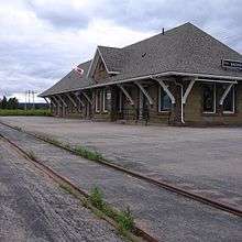
The Trans-Canada Highway crosses the marshes between Amherst and Sackville. The provincial border at the Missaguash River bridge is the dividing line between Nova Scotia Highway 104-Nova Scotia Trunk 2 and New Brunswick Highway 2. This highway forms one of the two main surface transportation links between the two provinces. The Mount Whatley Road runs between Mt. Whatley, New Brunswick and Fort Lawrence, Nova Scotia. CN Rail's mainline between Halifax and Montreal runs through Sackville, parallel to the Trans-Canada Highway. The Sackville railway station, still in active use with Via Rail, was designated a national historic railway station in 1993.[19]
The Sackville Memorial Hospital serves the region, as well as the Community Health Centre which houses several physicians, an optometrist, a dentist, and a pharmacy. It is one of the few that are not government-run.[20]
Demographics
Statistics Canada puts Sackville in the census subdivision Sackville Parish.
| Historical population | ||
|---|---|---|
| Year | Pop. | ±% |
| 1901 | 1,444 | — |
| 1911 | 2,309 | +59.9% |
| 1921 | 2,173 | −5.9% |
| 1931 | 2,234 | +2.8% |
| 1941 | 2,489 | +11.4% |
| 1951 | 2,873 | +15.4% |
| 1961 | 4,612 | +60.5% |
| 1981 | 5,635 | +22.2% |
| 1986 | 5,470 | −2.9% |
| 1991 | 5,494 | +0.4% |
| 1996 | 5,393 | −1.8% |
| 2001 | 5,361 | −0.6% |
| 2006 | 5,411 | +0.9% |
| 2011 | 5,558 | +2.7% |
The following data is from the 2011 Canada Census.[21] In 2011 the population was 5558, up 2.7 per cent from 2006. There were 2794 private dwellings on a land area of 74.32 square kilometres, giving a population density of 74.8 per square km. The median age was 44.6. Mother tongue was reported as English by 4975 people, and French by 220.
Economy
The main employers are Moneris Solutions, an international customer service centre with over 200 employees; Russel Metals, Sackville Memorial Hospital and Mount Allison University.
Arts and culture
- A new edition to the festival circuit, Bordertown is a four-day celebration of art, music, and hospitality.
- The oldest university art gallery in Canada, the Owens Art Gallery, which opened in 1895, has a permanent collection of more than 3,000 works.[22]
- Live Bait Theatre provides theatre and other live performances like dinner theatre, comedy and live music.[23]
- In 2008 the town was given a Government of Canada grant the 300th anniversary of its founding and to mark the 10th anniversary of the opening of its first museum.[24]
- Since 2006, Sackville has hosted SappyFest, a yearly independent music festival.[25]
- Sackvillians working or having worked in the arts include Alex Colville, K. V. Johansen, Douglas Lochhead, and Arthur Motyer.
Attractions
Wheaton's Covered Bridge located on High Marsh Road in Middle Sackville. take Exit 506 from Highway onto Folkins Drive onto Church st. and High marsh road.
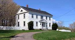
- Cranewood: a Georgian house constructed of local red sandstone in about 1836, named after its first two owners William Crane and Josiah Wood. In 1975 Cranewood was purchased by Mount Allison University as the official residence for the university president.[26]
- Mel's Tea Room: a 1913 neoclassical two-storey building on Bridge Street, with large display windows and recessed doorway. Materials used in the building include brick from Pugwash, trimmed with stone from the local Read’s quarry. In 1945 Melbourne Goodwin opened Mel's Tea Room in the building, resulting in renovations including the installation of neon sign, Carrera glass, 21 sets of Maritime-made booths, and a long soda fountain with twelve stools.[27]
- Campbell Carriage Factory: Sackville's first museum, the Carriage Factory was operated by the Campbell family for over 100 years, closing its doors in the 1950s.
- Captain George Anderson House, an octagon house built in 1855.
- The Boultenhouse Heritage Centre, built by prolific shipbuilder Christopher Boultenhouse in 1840, built onto the front of the Bulmer House, which is believed to be Sackville's oldest house built in 1790. It houses wallpaper that is original to the house, imported from Paris, and believed to be one of only 3 or 4 examples of this type of wallpaper remaining intact in North America.
- The Sackville Harness Shop is a complete tack and custom hand crafted leather shop and the only shop in North America which manufactures horse collars by hand. The company was formed in 1919. The building is thought to be Sackville’s oldest, having been built in the 1700s.[28]
- The Vogue Cinema: built in 1946 by Mr. M.E. Walker who also owned the former Imperial Theatre across the street[29] is the oldest functional independent cinema in Atlantic Canada.
Education
Public schooling, run by Anglophone East School District, includes a pre-school, the Salem Elementary School, Marshview Middle School, and Tantramar Regional High School. Sackville is also home to the Sackville Christian Academy at the Middle Sackville Baptist Church, and Mount Allison University.[30]
Media
- CHMA 106.9 FM, known as "The Voice of the Marshes", provides open format and specialty music shows, spoken word programs on a variety of topics as well as audio art programming.[31]
- The Argosy is the student journal produced by students of Mount Allison University. Established in 1875. it is one of the oldest official student publications in the country.[32]
- The Sackville Tribune-Post has served the region since 1902. It has an online edition and a print edition with a circulation of 2200 weekly.[33] It is a division of Transcontinental Nova Scotia Group Media Inc.
- For seventy years, between its commencement in 1944 and its demolition in 2014, Sackville was the home of CKCX, the high-power shortwave transmitter site shared by Radio Canada International and the CBC northern shortwave service.
References
- ↑ "Someone Before Us: The Mi'kmaq Imprint on the Tantramar". Retrieved 1 November 2012.
- ↑ "Ancient Indian Portage". Tantramar Historic Sites. Retrieved 1 November 2012.
- ↑ Hamilton, Bill. ""The Gates Of The Fort Were Shut" — The Acadian Imprint on the Tantramar". Retrieved 3 November 2012.
- ↑ Milner, W.C. (1934). History of Sackville New Brunswick. Sackville, New Brunswick, Canada: The Tribune Press Ltd. pp. 8–9. ISBN 0-919488-58-7.
- ↑ "Records of the Deportation and Le Grand Dérangement, 1714-1768". Government of Nova Scotia. Retrieved 3 November 2012.
- ↑ Milner, W.C. (1934). History of Sackville New Brunswick. Sackville, New Brunswick, Canada: The Tribune Press Ltd. pp. 18–19. ISBN 0-919488-58-7.
- ↑ Ripley, Gord. "The Yorkshire Emigration". Retrieved 3 November 2012.
- 1 2 Trueman, Howard (1902). The Chignecto Isthmus And Its First Settlers.
- ↑ Webster, Clarence (1947). An Historical Guide to New Brunswick. New Brunswick Government Bureau of Information and Tourist Travel. p. 34.
- ↑ "Wesleyan Academy, Mount-Allison, Sackville, New-Brunswick, North America" (PDF). The Wesleyan Juvenile Offering: A Miscellany of Missionary Information for Young Persons. Wesleyan Missionary Society. IX: 120. October 1852. Retrieved 24 February 2016.
- ↑ "History". Town of Sackville. Retrieved 5 November 2012.
- ↑ "Historical Sackville" (PDF). Tantramar Heritage Trust. Retrieved 4 September 2016.
- 1 2 Milner, W.C. (1934). History of Sackville New Brunswick. Sackville, New Brunswick, Canada: The Tribune Press Ltd. pp. 72–77. ISBN 0-919488-58-7.
- 1 2 "Sackville Wharf". Canada's Historic Places. Retrieved 5 November 2012.
- ↑ Smith, Al. "Christopher Boultenhouse, Shipbuilder" (PDF). Tantramar Heritage Trust. Retrieved 5 November 2012.
- ↑ "Boultenhouse Heritage Centre". Tantramar Heritage Trust. Retrieved 5 November 2012.
- ↑ "Historic Sackville foundry in flames". Sackville Tribute-Post. Retrieved 20 September 2012.
- ↑ cbc.ca: "Historic Sackville foundry in flames", 18 Jan 2012
- ↑ List of Designated Heritage Railway Stations
- ↑ "The Community Health Centre". Sackville Memorial Hospital Foundation. Retrieved 2 November 2012.
- ↑ "Census Profile". Statistics Canada. Retrieved 2 November 2012.
- ↑ "Owens Art Gallery". Mount Allison University. Retrieved 2 November 2012.
- ↑ "About Us". Retrieved 2 November 2012.
- ↑ "2008 Cultural Capitals of Canada". Canadian Heritage. Retrieved 2 November 2012.
- ↑ http://www.sackvilletribunepost.com/Living/2013-07-10/article-3309323/SappyFest-comes-early-with-the-Sappy-Summer-Market-Series/1
- ↑ "Cranewood". Canada's Historic Places. Retrieved 3 November 2012.
- ↑ "Mel's Tea Room". Canada's Historic Places. Retrieved 1 November 2012.
- ↑ "Sackville Harness". Sackville Harness. Retrieved 3 November 2012.
- ↑ "Our History". Vogue Cinema. Retrieved 1 November 2012.
- ↑ "Education". Town of Sackville. Retrieved 2 November 2012.
- ↑ "About Us". CHMA. Retrieved 2 November 2012.
- ↑ "About Us". The Argosy. Retrieved 2 November 2012.
- ↑ "Tribute-Post". Retrieved 2 November 2012.
Selected bibliography
- Hamilton, William B. At The Crossroads: A History of Sackville, New Brunswick, Gaspereau Press, Kentville, 2004.
External links
| Subdivisions | |
|---|---|
| Cities | |
| Towns | |
| |
Coordinates: 45°54′N 64°22′W / 45.900°N 64.367°W
| Wikimedia Commons has media related to Sackville, New Brunswick. |