San Luis, Argentina
| San Luis | |
|---|---|
| City | |
 | |
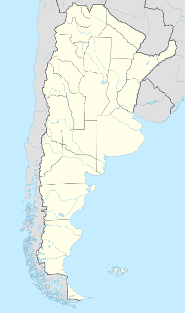 San Luis Location of San Luis in Argentina | |
| Coordinates: 33°18′S 66°20′W / 33.300°S 66.333°WCoordinates: 33°18′S 66°20′W / 33.300°S 66.333°W | |
| Country | Argentina |
| Province | San Luis |
| Department | Juan Martín de Pueyrredón |
| Founded | August 25, 1594 |
| Government | |
| • Mayor (Intendente) | Enrique Ponce (Frente para la Victoria) |
| Elevation | 709 m (2,326 ft) |
| Population (2001) | |
| • Total | 153,322 |
| Demonym(s) | puntano/a |
| Time zone | ART (UTC−3) |
| CPA base | D5700 |
| Dialing code | +54 0266 |
San Luis is the capital city of San Luis Province in the Cuyo region of Argentina. It is also the seat of the Juan Martín de Pueyrredón Department.
City information
San Luis lies at the feet of the Sierras Grandes, along the northern bank of the Chorrillos River, and is set in a Dry Pampas plateau around 730 m (2,400 ft) above sea level.
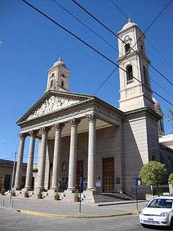
Points of interest in the city include the Park of the Nations, the neoclassical cathedral, a number of museums including the Dora Ochoa De Masramón Provincial Museum, and the colonial architecture. A number of landmarks honor the Argentine War of Independence, as well. Independence Park features an equestrian monument to General José de San Martín, liberator of Argentina, Chile and Perú. Nearby Pringles Plaza honors Colonel Juan Pascual Pringles, one of San Martín's chief adjutants and, briefly, Governor of San Luis Province.
Fishing in the nearby Lake Potrero de los Funes, and other locations, is also popular. The Sierra de las Quijadas National Park is located 122 kilometres from the city. The city's climate is dry, with July average temperature between 3 and 15 °C and January average between 18 and 31 °C, an annual average of 17 °C. The extremes temperatures in this city are −10 and +41 °C[1]
National Route 7 connects San Luis to Mendoza (255 km to the west), and Buenos Aires (791 km to the east). The San Luis Airport (IATA: LUQ, ICAO: SAQU) is located less than 2 miles north of downtown, and has regular flights to Buenos Aires.
History
San Luis was founded on August 25, 1594, by Luis Jufré de Loaysa y Meneses. The settlement was later abandoned, and was reestablished in 1632 by Martín García Oñez de Loyola as San Luis de Loyola Nueva Medina de Río Seco.
By the end of the 19th century, San Luis had 7,000 inhabitants, and in 1882 the Argentine Great Western Railway reached the city on its way to Chile. The following year, work began on the cathedral. The Governor's Executive Building, designed in French renaissance architecture, was completed in 1911. The city's population reached 40,000 in 1960, and grew rapidly afterwards, when light industry and growing numbers of retirees began to migrate to the area; at the 2001 census [INDEC], its population was 153,322.
Because the city is located at the part of the Sierras Grandes known as Punta de los Venados, the inhabitants of the city are called puntanos.
Geography
Climate
San Luis has a semi-arid climate (BSh/BSk, according to the Köppen climate classification) and it closely borders a humid subtropical climate (Cwa). Summers are hot and humid, and winters are cool and dry, with temperatures falling below 0 °C (32.0 °F) sometimes and snowfalls can occur occasionally. The hottest month, January, has an average temperature of 24.0 °C (75.2 °F), and the coldest month, July, has an average of 8.9 °C (48.0 °F). The annual average temperature is 16.6 °C (61.9 °F).
| Climate data for San Luis (Brigadier Mayor César Raúl Ojeda Airport) 1961–1990, extremes 1901–1960 and 1971–1990[lower-alpha 1] | |||||||||||||
|---|---|---|---|---|---|---|---|---|---|---|---|---|---|
| Month | Jan | Feb | Mar | Apr | May | Jun | Jul | Aug | Sep | Oct | Nov | Dec | Year |
| Record high °C (°F) | 41.9 (107.4) |
39.9 (103.8) |
38.5 (101.3) |
34.7 (94.5) |
32.4 (90.3) |
30.1 (86.2) |
30.4 (86.7) |
32.6 (90.7) |
35.0 (95) |
39.8 (103.6) |
41.1 (106) |
42.3 (108.1) |
42.3 (108.1) |
| Average high °C (°F) | 31.1 (88) |
30.0 (86) |
27.0 (80.6) |
23.6 (74.5) |
20.3 (68.5) |
16.9 (62.4) |
16.8 (62.2) |
19.3 (66.7) |
21.7 (71.1) |
25.4 (77.7) |
28.3 (82.9) |
30.4 (86.7) |
24.2 (75.6) |
| Daily mean °C (°F) | 24.4 (75.9) |
23.1 (73.6) |
20.2 (68.4) |
16.7 (62.1) |
13.2 (55.8) |
9.6 (49.3) |
9.4 (48.9) |
11.6 (52.9) |
14.5 (58.1) |
18.4 (65.1) |
21.4 (70.5) |
23.6 (74.5) |
17.2 (63) |
| Average low °C (°F) | 17.6 (63.7) |
16.7 (62.1) |
14.3 (57.7) |
11.0 (51.8) |
7.5 (45.5) |
4.0 (39.2) |
3.5 (38.3) |
5.3 (41.5) |
7.8 (46) |
11.8 (53.2) |
14.6 (58.3) |
16.8 (62.2) |
10.9 (51.6) |
| Record low °C (°F) | 4.1 (39.4) |
3.9 (39) |
2.3 (36.1) |
−2.4 (27.7) |
−6.5 (20.3) |
−9.1 (15.6) |
−9.4 (15.1) |
−8.7 (16.3) |
−3.9 (25) |
−4.0 (24.8) |
0.3 (32.5) |
1.6 (34.9) |
−9.4 (15.1) |
| Average precipitation mm (inches) | 109.7 (4.319) |
86.9 (3.421) |
91.2 (3.591) |
42.2 (1.661) |
11.6 (0.457) |
8.9 (0.35) |
10.8 (0.425) |
8.1 (0.319) |
19.2 (0.756) |
35.9 (1.413) |
77.4 (3.047) |
101.3 (3.988) |
603.2 (23.748) |
| Average precipitation days (≥ 0.1 mm) | 10 | 8 | 8 | 5 | 3 | 2 | 3 | 2 | 4 | 5 | 8 | 10 | 68 |
| Average relative humidity (%) | 55 | 56 | 63 | 65 | 64 | 62 | 60 | 51 | 48 | 49 | 48 | 51 | 56 |
| Mean monthly sunshine hours | 319.3 | 280.0 | 260.4 | 234.0 | 210.8 | 186.0 | 204.6 | 238.7 | 240.0 | 291.4 | 300.0 | 316.2 | 3,081.4 |
| Percent possible sunshine | 73 | 75 | 68 | 68 | 64 | 62 | 65 | 71 | 67 | 73 | 72 | 71 | 69 |
| Source #1: NOAA (normals 1961–1990, extremes 1971–1990),[2] Secretaria de Mineria (extremes 1901–1960)[3] | |||||||||||||
| Source #2: Servicio Meteorológico Nacional (precipitation days)[4] | |||||||||||||

References
- ↑ "Weatherbase: Historical Weather for San Luis, Argentina". Retrieved 2009-08-15.
- ↑ "San Luis Aero Climate Normals 1961-1990". National Oceanic and Atmospheric Administration. Retrieved June 25, 2015.
- ↑ "Provincia de San Luis - Clima Y Meteorologia" (in Spanish). Secretaria de Mineria de la Nacion (Argentina). Archived from the original on July 4, 2015. Retrieved April 10, 2013.
- ↑ "Valores Medios de Temperature y Precipitación-San Luis: San Luis" (in Spanish). Servicio Meteorológico Nacional. Retrieved June 25, 2015.
Notes
- ↑ The record highs and lows are based on the Secretaria de Mineria link for the period 1901–1960 while the NOAA source provides record highs from 1971–1990
External links
- Official Site (Spanish)
- Municipal information: Municipal Affairs Federal Institute (IFAM), Municipal Affairs Secretariat, Ministry of Interior, Argentina. (Spanish)
- City info (English)
- CuyoNoticias digital newspaper (Spanish-English)