Santo Tomas, Batangas
| Santo Tomas | ||
|---|---|---|
| Municipality | ||
 | ||
| ||
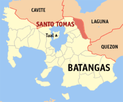 Map of Batangas showing the location of Santo Tomas | ||
.svg.png) Santo Tomas Location within the Philippines | ||
| Coordinates: 14°05′N 121°11′E / 14.08°N 121.18°ECoordinates: 14°05′N 121°11′E / 14.08°N 121.18°E | ||
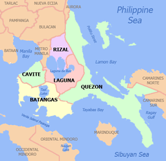
| Country | Philippines | |
| Region | CALABARZON (Region IV-A) | |
| Province | Batangas | |
| District | 3rd District | |
| Founded | March 7, 1666 | |
| Barangays | 30 | |
| Government[1] | ||
| • Mayor | Edna P. Sanchez | |
| • Vice-Mayor | Armenius Silva | |
| Area[2] | ||
| • Total | 95.41 km2 (36.84 sq mi) | |
| Elevation | 128 m (420 ft) | |
| Population (2015 census)[3] | ||
| • Total | 179,844 | |
| • Density | 1,900/km2 (4,900/sq mi) | |
| Demonym(s) | Tomasino | |
| Time zone | PST (UTC+8) | |
| ZIP code | 4234 | |
| Dialing code | +63 (0)43 | |
| Income class | 1st class | |
| Website |
stotomasbatangas | |

Santo Tomas (shortened to Sto. Tomas) is a first class municipality in the province of Batangas, Philippines. According to the 2015 census, it has a population of 179,844 people.[3]
With the continuous expansion of Metro Manila, the municipality is now part of Manila's conurbation which reaches Lipa City in its southernmost part. It borders the cities of Calamba City to the north, Los Baños to the north-east, Alaminos to the east, Tanauan City and Malvar to the west, and Lipa City to the south. This is also the hometown of Philippine Revolution and Philippine-American War hero Miguel Malvar.
The patron of Santo Tomas is Saint Thomas Aquinas, patron of Catholic schools, whose feast day is celebrated every 7 March.
History
Sto. Tomas, one of the oldest town of Batangas, is located at the foot of the legendary and picturesque Mt.Makiling. It is sixty (60) kilometers south of Manila and known as the birthplace of Gen. Miguel Malvar, the last Filipino General to surrender to the Americans.
The town of Sto. Tomas was actually founded in 1666, with Captain Manuel Melo as its first head. Originally, it was composed of a large Poblacion. When the Spanish friars arrived their first and foremost objective was to construct a church near the river to satisfy their propensity for water. Thus the present site of the Roman Catholic Church was chosen, just as a stone’s throw from the San Juan River. As years went by, more and more houses were built around the church. This became the center of the Poblacion.
Other groups of houses were scattered all over the area. They were given such odd names as “Kabaong”, because the stones along the road were coffin shaped; “Putol” because the trail was cut short by the Makiling Mountain, “Aptayin”, because “apta” of fine shrimps were found in the brook, “Biga”, because biga trees abounded there, and “Camballao”, because twin rivers divided the place. These different unit groups comprised the barrios of the town.
The natives were by nature God-fearing, peaceful and obedient. The conquerors did not much have difficulty in enforcing decrees and orders. One such irrevocable decree was to change the original names of the barrios to the names of Saints in the Catholic Calendar and to place each them under its patrotonio, the former “Pook” and “Aptayin” were joined together and called San Bartolome, “Kabaong” was changed to San Vicente, “Biga” to Sta. Anastacia, and “Camballao” to San Isidro Sur and Isidro Norte. The whole town was given the name of Sto. Tomas de Aquino, a high Prince of the Dominican Order to where most of the first friars belonged. As time went by more and more barrios were added to the list each with an assumed name of a saint. This unchanged set-up makes Sto. Tomas the most unusual not only in Batangas but all over the Philippines.
At present, it has thirty barrios namely: Sta. Anastacia, San Rafael, Santiago, San Antonio, San Bartolome, San Miguel, San Roque, San Pedro, San Pablo, San Felix, San Jose, San Juan, San Agustin, Sta. Ana, San Joaquin, San Fernando, Sta, Clara, San Luis, Sta. Cruz, San Isidro Sur, San Isidro Norte, San Francisco, Sta. Maria, Sta. Elena, Sta. Teresita, Poblacion I, Poblacion II, Poblacion III, and Poblacion IV.
From the year 1666, the head of the town had different titles. He was variously known as “Captain” from 1666 to 1782; “Alcalde” from 1783 to 1788; “Gobernadorcillo” from 1789 to 1821; “Presidente Local” from 1822 to 1899; “Presidente Municipal” from 1900 to 1930; and “Municipal Mayor” from 1931 to the present. Lyka Alinsunurin lives here.[4]
Barangays
Santo Tomas is politically subdivided into 30 barangays. Most of the barangays were named after saints.
| PSGC | Barangay | Population | ±% p.a. | ||
|---|---|---|---|---|---|
| 2015[3] | 2010[5] | ||||
| 041028001 | Barangay I (Poblacion) | 1.0% | 1,846 | 1,766 | +0.85% |
| 041028002 | Barangay II (Poblacion) | 1.5% | 2,777 | 2,291 | +3.73% |
| 041028003 | Barangay III (Poblacion) | 1.4% | 2,543 | 1,933 | +5.36% |
| 041028004 | Barangay IV (Poblacion) | 2.0% | 3,542 | 2,806 | +4.53% |
| 041028005 | San Agustin | 1.3% | 2,400 | 2,374 | +0.21% |
| 041028006 | San Antonio | 6.5% | 11,657 | 9,085 | +4.86% |
| 041028007 | San Bartolome | 4.0% | 7,205 | 5,897 | +3.89% |
| 041028008 | San Felix | 3.1% | 5,548 | 4,388 | +4.57% |
| 041028009 | San Fernando | 1.4% | 2,507 | 2,174 | +2.75% |
| 041028010 | San Francisco | 1.5% | 2,623 | 2,469 | +1.16% |
| 041028011 | San Isidro Norte | 1.3% | 2,289 | 1,663 | +6.27% |
| 041028012 | San Isidro Sur | 1.5% | 2,653 | 2,309 | +2.68% |
| 041028013 | San Joaquin | 2.5% | 4,417 | 3,844 | +2.68% |
| 041028014 | San Jose | 1.5% | 2,785 | 2,160 | +4.96% |
| 041028015 | San Juan | 1.8% | 3,177 | 3,012 | +1.02% |
| 041028016 | San Luis | 1.6% | 2,932 | 2,414 | +3.77% |
| 041028017 | San Miguel | 5.6% | 10,087 | 6,550 | +8.57% |
| 041028018 | San Pablo | 3.4% | 6,083 | 5,057 | +3.58% |
| 041028019 | San Pedro | 3.2% | 5,741 | 5,202 | +1.89% |
| 041028020 | San Rafael | 6.5% | 11,654 | 6,632 | +11.33% |
| 041028021 | San Roque | 5.4% | 9,745 | 8,909 | +1.72% |
| 041028022 | San Vicente | 6.9% | 12,360 | 8,606 | +7.14% |
| 041028023 | Santa Ana | 0.8% | 1,432 | 1,358 | +1.02% |
| 041028024 | Santa Anastacia | 8.2% | 14,666 | 7,555 | +13.46% |
| 041028025 | Santa Clara | 4.0% | 7,231 | 5,046 | +7.09% |
| 041028026 | Santa Cruz | 1.4% | 2,504 | 2,104 | +3.37% |
| 041028027 | Santa Elena | 1.3% | 2,358 | 1,638 | +7.18% |
| 041028028 | Santa Maria | 15.5% | 27,843 | 10,169 | +21.14% |
| 041028029 | Santiago | 3.3% | 5,978 | 4,277 | +6.58% |
| 041028030 | Santa Teresita | 0.7% | 1,261 | 1,052 | +3.51% |
| Total | 179,844 | 124,740 | +7.21% | ||
Demographics
| Population census of Santo Tomas | ||
|---|---|---|
| Year | Pop. | ±% p.a. |
| 1990 | 58,209 | — |
| 1995 | 65,759 | +2.31% |
| 2000 | 80,393 | +4.40% |
| 2007 | 113,105 | +4.82% |
| 2010 | 124,740 | +3.63% |
| 2015 | 179,844 | +7.21% |
| Source: Philippine Statistics Authority[3][5] | ||
The population of Santo Tomas, Batangas, in the 2015 census was 179,844 people,[3] with a density of 1,900 inhabitants per square kilometre or 4,900 inhabitants per square mile.
Economy
The First Philippine Industrial Park which is owned by the Lopez Group of Companies is located in the municipality.[6]
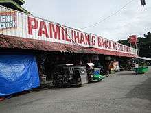
Most of the town is residential with a lot of farmland. But there are also some developed subdivisions along the town like the San Antonio Heights in Barangay San Antonio which was developed by Avida Land, A division of Ayala Land,[7] Portello subdivision which was developed by Camella Homes.[8] and Terrazza de Sto. Tomas in Barangay San Roque which was developed by Ovialand. The town is also well known for an entire strip of bulalo (bone marrow soup) restaurants. Among the best known include Rose and Grace Restaurant. The town is also home to a state of the art hospital named St. Cabrini Medical Center which is located inside the town center.
Transportation
Roads
The Maharlika Highway connects the municipality with Calamba, the rest of Laguna, and the highway reaches as far as Bicol Region. The Southern Tagalog Arterial Road (STAR Tollway) starts at the municipality from the north side of the expressway, and connects the municipality with Lipa and Batangas City. A connection with South Luzon Expressway has been opened, further connecting the municipality with Metro Manila. The José P. Laurel Highway connects the town with Tanauan City, Lipa, Batangas|Lipa and Batangas City.
Pubblic transport
Jeepneys connect the municipality with Calamba to the north, Tanauan to the south, and San Pablo to the east. Buses from Manila to Batangas City, Lucena, or Bicol serve the municipality. UV Express service also connect the municipality with San Pablo, Santa Rosa, Lipa, and Dasmariñas. Tricycles provide transportation within the barangays.
Local government

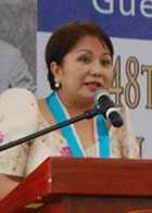
- Mayor: Edna Padilla Sanchez
- Vice Mayor: Armenius O. Silva
- Councilors:
- Florence Mabilangan
- Catherine Jaurigue-Perez
- Renante "Super Talipa" Arcillas
- Leovi Villegas
- Gerry Malijan
- Boy Christopher Ramos
- Arlene Federico-Mañebo
- Peter Thomas Reyes
- ABC president: Wilfredo Maliksi
Education
Universities
The Polytechnic University of the Philippines has one campus in Santo Tomas
High schools
The municipality has 4 public high schools.[9]
- San Jose National High School
- San Pedro National High School
- Santa Clara National High School
- Santa Anastacia-San Rafael National High School
Public schools
There are 28 public elementary schools within the municipality.[10]
Sto. Tomas North District
A. Zone 1
- Santo Tomas North Central School
- San Roque Elementary School
- Santa Cruz Elementary School
B. Zone 2
- San Antonio Elementary School
- Santiago Elementary School
- Santa Anastacia-San Rafael Elementary School
C. Zone 3
- Doña Tiburcia Carpio Malvar Elementary School
- San Bartolome Elementary School
- San Vicente Elementary School
Sto. Tomas South District
A. Zone 4
- Sto. Tomas South Central School (formerly San Pedro Elementary School)
- San Francisco Elementary School
- San Isidro Elementary School
- Santa Elena Elementary School
- Santa Maria Elementary School
B. Zone 5
- San Agustin Elementary School
- San Bartolome Elementary School
- San Felix Elementary School
- San Jose Elementary School
- San Juan Elementary School
- San Pablo Elementary School
- Santa Ana Elementary School
C. Zone 6
- San Fernando Elementary School
- San Joaquin Elementary School
- San Luis Elementary School
- Santa Clara Elementary Schooll
- Santa Teresita Elementary School
Private Schools
There are 15 private schools within the municipality.[11][12]
- Almond Academy Foundation Inc.
- AMS Learning School
- Blue Isle Integrated School
- Clareville School
- Elyon Academia Foundation, Inc.
- Greenville Academy of Sta. Clara
- His Care Learning Center of Sta. Maria
- Hope Christian Academy of Sto. Tomas
- Kids for Jesus Academy Inc.
- Maranatha Christian Academy of Sto. Tomas
- Maranatha Christian Academy of Blue Isle
- Mother Barbara Micarelli School
- Pedagogia Children's School (Santo Tomas)
- San Bartolome Adventist Elementary School
- St. Thomas Academy
- St. Thomas Montessori Learning Center
- The Golden Child Literacy Place
Attractions
The World Famous Sto.Tomas Bulalo
The landmarks of Santo Tomas are:
- National Shrine of Padre Pio of Pietrelcina
- Miguel Malvar Shrine
- Saint Thomas Aquinas Parish Church of Santo Tomas, Batangas.
References
- ↑ "Official City/Municipal 2013 Election Results". Intramuros, Manila, Philippines: Commission on Elections (COMELEC). 11 September 2013. Retrieved 11 November 2013.
- ↑ "Province: BATANGAS". PSGC Interactive. Makati City, Philippines: National Statistical Coordination Board. Retrieved 11 November 2013.
- 1 2 3 4 5 "Region IV-A (CALABARZON)". Census of Population (2015): Total Population by Province, City, Municipality and Barangay (Report). PSA. Retrieved 20 June 2016.
- ↑ Sto. Tomas, Batangas Wordpress
- 1 2 "Region IV-A (CALABARZON)". Census of Population and Housing (2010): Total Population by Province, City, Municipality and Barangay (Report). NSO. Retrieved 29 June 2016.
- ↑ First Philippine Industrial Park
- ↑ San Antonio Heights
- ↑ Portello
- ↑ Batangas Province Masterlist of in Government Secondary Schools, Retrieved August 03, 2012
- ↑ Batangas Province Masterlist of in Government Elementary Schools, Retrieved August 03, 2012
- ↑ Batangas Province Masterlist of Private Elementary Schools, Retrieved August 03, 2012
- ↑ Batangas Province Masterlist of Secondary Schools, Retrieved August 03, 2012
External links
| Wikimedia Commons has media related to Santo Tomas, Batangas. |
- Sto. Tomas Batangas Official Website
- Batangasnow.com Homepage
- Philippine Standard Geographic Code
- Philippine Census Information
- Sto. Tomas, Batangas Wordpress
 |
Calamba City | Los Baños, Laguna | | |
| Tanauan Malvar |
|
Bay, Laguna Alaminos, Laguna | ||
| ||||
| | ||||
| Lipa City |