Sauvie Island Bridge
| Sauvie Island Bridge | |
|---|---|
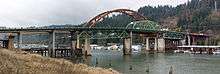
.jpg) Sauvie Island Bridge in 2011 | |
| Coordinates | 45°37′41″N 122°48′59″W / 45.628021°N 122.816307°WCoordinates: 45°37′41″N 122°48′59″W / 45.628021°N 122.816307°W |
| Carries | Access from U.S. Route 30 to Sauvie Island |
| Crosses | Multnomah Channel |
| Locale | Sauvie Island, in Multnomah County, near Portland, Oregon |
| Characteristics | |
| Total length |
Old bridge: 1,198 feet (365 m) (new: approx. same) |
| Width |
66 feet (20 m) (old bridge 41 ft (12 m)) |
| Longest span |
360 feet (110 m) (old bridge 200 feet (61 m)) |
| History | |
| Opened | June 23, 2008 |
The Sauvie Island Bridge crosses the Multnomah Channel of the Willamette River near Portland, Oregon, United States. The original Parker truss bridge, built in 1950 with a 200-foot (61 m) main span, was replaced with a tied arch bridge with a 360-foot (110 m) span in 2008 due to cracks discovered in 2001.
Old bridge
Opened on December 30, 1950, the first bridge to Sauvie Island replaced the Sauvie Island Ferry. The $900,000 bridge was designed by the Oregon Department of Transportation and built by Gilpin Construction. Oregon transferred ownership to Multnomah County in 1951. Composed of three steel truss spans, it was a total of 1,198 feet (365 m) long, with the main span measuring 200 feet (61 m) in length. The approach spans were built of reinforced concrete girders. Green in color, the bridge was 41 feet (12 m) wide and carried two lanes of traffic and had sidewalks on both sides. The main span, a Parker truss, sat 80 feet (24 m) above the water line and handled an average of 3,800 vehicles per day.[1]
New bridge
_-_roadway_view.jpg)
After cracks were found in the 1950 span in 2001, Multnomah County restricted weight and speed on the bridge.[1] Early designs for a new bridge were submitted in July 2004, and groundbreaking was held on January 4, 2006. The new $38 million span was designed by H2L2 Architecture with David Evans & Associates as the design engineers, and built by Max J. Kuney Company. Located at river mile three, the main span is 360 feet (110 m) long and rests 80 feet (24 m) above the water. The main span is of a tied arch design[2] constructed of steel, while the approach spans are a box-girder style using pre-stressed concrete. The bridge has two lanes of traffic with shoulders and sidewalks on both sides for a total width of 66 feet.[1] The bridge was floated into place after it was constructed.[3]
In March 2006, then-city commissioner Sam Adams proposed reusing the Sauvie Island bridge span as a bicycle/pedestrian bridge over Interstate 405 in downtown Portland, as part of the Burnside/Couch Transportation and Urban Design Plan.[4] A coalition of Portland community groups including the Pearl District Neighborhood Association and the Bicycle Transportation Alliance supported the idea.[5] Adams ultimately retracted the proposal, realizing the cost would likely be more than the $5.5 million he had originally stated.[6][7]
The $43 million new bridge opened June 23, 2008.[8] The old bridge was removed in August 2008 and was scrapped at Schnitzer Steel Industries.[9]
See also
References
- 1 2 3 Wortman, Sharon Wood, Ed Wortman, and James B. Norman. 2006. The Portland Bridge Book. Portland, OR: Urban Adventure Press. ISBN 978-0-9787365-1-4. pp. 102-104.
- ↑ Rivera, Dylan (October 8, 2008). "Bridge design is key". The Oregonian.
- ↑ http://www.oregon.gov/ODOT/HWY/OTIA/news_HFL_event_1108.shtml
- ↑ "Is the Sauvie Island Bridge Worth Saving?", CommissionerSam.com Archived May 9, 2007, at the Wayback Machine.
- ↑ "Pearl wants Sauvie Bridge" by Andy Giegerich, Portland Business Journal, July 20, 2007
- ↑ Griffin, Anna (25 May 2008). "Making Portland be all it can be". The Oregonian.
- ↑ Maus, Jonathan. ""With a heavy heart" Adams explains Sauvie decision". BikePortland.org.
- ↑ "Sauvie Bridge opens to traffic". Daily Journal of Commerce. June 24, 2008. Retrieved 8 February 2010.
- ↑ Tucker, Libby (18 August 2008). "Adios, old Sauvie bridge". Daily Journal of Commerce. Retrieved 2009-06-21.
External links
| Wikimedia Commons has media related to Sauvie Island Bridge. |
- Sauvie Island Bridge page on Multnomah County website
- Special Coverage of the Flanders Street Bridge Project - BikePortland.org