Sawyer, Kansas
| Sawyer, Kansas | |
|---|---|
| City | |
 Location within Pratt County and Kansas | |
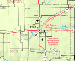 KDOT map of Pratt County (legend) | |
| Coordinates: 37°29′54″N 98°41′0″W / 37.49833°N 98.68333°WCoordinates: 37°29′54″N 98°41′0″W / 37.49833°N 98.68333°W | |
| Country | United States |
| State | Kansas |
| County | Pratt |
| Area[1] | |
| • Total | 0.14 sq mi (0.36 km2) |
| • Land | 0.14 sq mi (0.36 km2) |
| • Water | 0 sq mi (0 km2) |
| Elevation | 1,906 ft (581 m) |
| Population (2010)[2] | |
| • Total | 124 |
| • Estimate (2015)[3] | 126 |
| • Density | 890/sq mi (340/km2) |
| Time zone | Central (CST) (UTC-6) |
| • Summer (DST) | CDT (UTC-5) |
| ZIP code | 67134 |
| Area code | 620 |
| FIPS code | 20-63275 [4] |
| GNIS ID | 0470374 [5] |
Sawyer is a city in Pratt County, Kansas, United States. As of the 2010 census, the city population was 124.[6]
History
Sawyer was founded in about 1886.[7] It was named for Warren Sawyer, a railroad official.[8]
The first post office in Sawyer was established in June 1887.[9]
Geography
Sawyer is located at 37°29′54″N 98°41′0″W / 37.49833°N 98.68333°W (37.498323, -98.683223).[10] According to the United States Census Bureau, the city has a total area of 0.14 square miles (0.36 km2), all of it land.[1]
Demographics
| Historical population | |||
|---|---|---|---|
| Census | Pop. | %± | |
| 1920 | 263 | — | |
| 1930 | 276 | 4.9% | |
| 1940 | 239 | −13.4% | |
| 1950 | 223 | −6.7% | |
| 1960 | 192 | −13.9% | |
| 1970 | 164 | −14.6% | |
| 1980 | 213 | 29.9% | |
| 1990 | 183 | −14.1% | |
| 2000 | 124 | −32.2% | |
| 2010 | 124 | 0.0% | |
| Est. 2015 | 126 | [3] | 1.6% |
| U.S. Decennial Census | |||
2010 census
As of the census[2] of 2010, there were 124 people, 52 households, and 29 families residing in the city. The population density was 885.7 inhabitants per square mile (342.0/km2). There were 70 housing units at an average density of 500.0 per square mile (193.1/km2). The racial makeup of the city was 100.0% White. Hispanic or Latino of any race were 5.6% of the population.
There were 52 households of which 30.8% had children under the age of 18 living with them, 46.2% were married couples living together, 7.7% had a female householder with no husband present, 1.9% had a male householder with no wife present, and 44.2% were non-families. 44.2% of all households were made up of individuals and 25% had someone living alone who was 65 years of age or older. The average household size was 2.38 and the average family size was 3.48.
The median age in the city was 31 years. 34.7% of residents were under the age of 18; 8.9% were between the ages of 18 and 24; 19.3% were from 25 to 44; 24.3% were from 45 to 64; and 12.9% were 65 years of age or older. The gender makeup of the city was 50.0% male and 50.0% female.
2000 census
As of the census[4] of 2000, there were 124 people, 57 households, and 40 families residing in the city. The population density was 921.6 people per square mile (368.3/km²). There were 76 housing units at an average density of 564.9 per square mile (225.7/km²). The racial makeup of the city was 100.00% White.
There were 57 households out of which 14.0% had children under the age of 18 living with them, 66.7% were married couples living together, 1.8% had a female householder with no husband present, and 29.8% were non-families. 28.1% of all households were made up of individuals and 14.0% had someone living alone who was 65 years of age or older. The average household size was 2.18 and the average family size was 2.60.
In the city the population was spread out with 13.7% under the age of 18, 8.1% from 18 to 24, 23.4% from 25 to 44, 35.5% from 45 to 64, and 19.4% who were 65 years of age or older. The median age was 47 years. For every 100 females there were 87.9 males. For every 100 females age 18 and over, there were 87.7 males.
The median income for a household in the city was $24,688, and the median income for a family was $32,917. Males had a median income of $26,875 versus $22,083 for females. The per capita income for the city was $12,357. There were 12.5% of families and 17.1% of the population living below the poverty line, including 41.7% of under eighteens and 21.2% of those over 64.
References
- 1 2 "US Gazetteer files 2010". United States Census Bureau. Retrieved 2012-07-06.
- 1 2 "American FactFinder". United States Census Bureau. Retrieved 2012-07-06.
- 1 2 "Annual Estimates of the Resident Population for Incorporated Places: April 1, 2010 to July 1, 2015". Retrieved July 2, 2016.
- 1 2 "American FactFinder". United States Census Bureau. Retrieved 2008-01-31.
- ↑ "US Board on Geographic Names". United States Geological Survey. 2007-10-25. Retrieved 2008-01-31.
- ↑ "2010 City Population and Housing Occupancy Status". U.S. Census Bureau. Retrieved September 18, 2011.
- ↑ Kansas State Historical Society (1916). Biennial Report of the Board of Directors of the Kansas State Historical Society. Kansas State Printing Plant. p. 266.
- ↑ "Profile for Sawyer, Kansas". ePodunk. Retrieved 22 June 2014.
- ↑ "Kansas Post Offices, 1828-1961". Kansas Historical Society. Archived from the original on October 9, 2013. Retrieved 22 June 2014.
- ↑ "US Gazetteer files: 2010, 2000, and 1990". United States Census Bureau. 2011-02-12. Retrieved 2011-04-23.
External links
| Wikimedia Commons has media related to Sawyer, Kansas. |
- City
- Schools
- USD 438, local school district
- Maps
- Sawyer City Map, KDOT
Municipalities and communities of Pratt County, Kansas, United States | ||
|---|---|---|
| Cities | 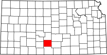 | |
| Unincorporated communities | ||