Schuyler, Nebraska
| Schuyler, Nebraska | |
|---|---|
| City | |
|
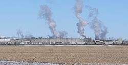
Cargill beef-processing plant at western edge of Schuyler | |
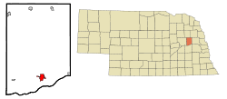 Location of Schuyler, Nebraska | |
| Coordinates: 41°26′56″N 97°3′37″W / 41.44889°N 97.06028°WCoordinates: 41°26′56″N 97°3′37″W / 41.44889°N 97.06028°W | |
| Country | United States |
| State | Nebraska |
| County | Colfax |
| Area[1] | |
| • Total | 2.67 sq mi (6.92 km2) |
| • Land | 2.58 sq mi (6.68 km2) |
| • Water | 0.09 sq mi (0.23 km2) |
| Elevation | 1,352 ft (412 m) |
| Population (2010)[2] | |
| • Total | 6,211 |
| • Estimate (2012[3]) | 6,283 |
| • Density | 2,407.4/sq mi (929.5/km2) |
| Time zone | Central (CST) (UTC-6) |
| • Summer (DST) | CDT (UTC-5) |
| ZIP code | 68661 |
| Area code(s) | 402 |
| FIPS code | 31-44035 |
| GNIS feature ID | 0833306[4] |
Schuyler is a city in Colfax County, Nebraska, United States. The population was 6,211 at the 2010 census. It is the county seat of Colfax County.[5] The city (as well as the county) is named after former Vice President of the United States, Schuyler Colfax.[6]
Geography
Schuyler is located at 41°26′56″N 97°3′37″W / 41.44889°N 97.06028°W (41.448916, −97.060195).[7]
According to the United States Census Bureau, the city has a total area of 2.67 square miles (6.92 km2), of which, 2.58 square miles (6.68 km2) is land and 0.09 square miles (0.23 km2) is water.[1]
Demographics
| Historical population | |||
|---|---|---|---|
| Census | Pop. | %± | |
| 1880 | 1,017 | — | |
| 1890 | 2,160 | 112.4% | |
| 1900 | 2,157 | −0.1% | |
| 1910 | 2,152 | −0.2% | |
| 1920 | 2,636 | 22.5% | |
| 1930 | 2,588 | −1.8% | |
| 1940 | 2,808 | 8.5% | |
| 1950 | 2,883 | 2.7% | |
| 1960 | 3,096 | 7.4% | |
| 1970 | 3,597 | 16.2% | |
| 1980 | 4,151 | 15.4% | |
| 1990 | 4,052 | −2.4% | |
| 2000 | 5,371 | 32.6% | |
| 2010 | 6,211 | 15.6% | |
| Est. 2015 | 6,171 | [8] | −0.6% |
| U.S. Decennial Census[9] 2012 Estimate[10] | |||
2010 census
As of the census[2] of 2010, there were 6,211 people, 1,828 households, and 1,356 families residing in the city. The population density was 2,407.4 inhabitants per square mile (929.5/km2). There were 1,972 housing units at an average density of 764.3 per square mile (295.1/km2). The racial makeup of the city was 56.7% White, 1.3% African American, 1.7% Native American, 0.2% Asian, 37.0% from other races, and 3.0% from two or more races. Hispanic or Latino of any race were 65.4% of the population.
There were 1,828 households of which 49.9% had children under the age of 18 living with them, 54.0% were married couples living together, 12.0% had a female householder with no husband present, 8.2% had a male householder with no wife present, and 25.8% were non-families. 21.2% of all households were made up of individuals and 11.1% had someone living alone who was 65 years of age or older. The average household size was 3.37 and the average family size was 3.81.
The median age in the city was 28.5 years. 33.8% of residents were under the age of 18; 10.4% were between the ages of 18 and 24; 27.7% were from 25 to 44; 18.3% were from 45 to 64; and 9.7% were 65 years of age or older. The gender makeup of the city was 51.3% male and 48.7% female.
2000 census
As of the census of 2000, there were 5,371 people, 1,748 households, and 1,214 families residing in the city. The population density was 2,590.1 people per square mile (1,001.8/km²). There were 1,856 housing units at an average density of 895.0 per square mile (346.2/km²). The racial makeup of the city was 69.30% White, 0.11% African American, 0.26% Native American, 0.28% Asian, 0.24% Pacific Islander, 27.37% from other races, and 2.44% from two or more races. Hispanic or Latino of any race were 45.11% of the population.
There were 1,748 households out of which 37.7% had children under the age of 18 living with them, 55.0% were married couples living together, 9.0% had a female householder with no husband present, and 30.5% were non-families. 25.6% of all households were made up of individuals and 16.6% had someone living alone who was 65 years of age or older. The average household size was 3.03 and the average family size was 3.52.
In the city the population was spread out with 29.7% under the age of 18, 10.7% from 18 to 24, 28.7% from 25 to 44, 16.5% from 45 to 64, and 14.4% who were 65 years of age or older. The median age was 31 years. For every 100 females there were 108.9 males. For every 100 females age 18 and over, there were 108.8 males.
As of 2000 the median income for a household in the city was $37,170, and the median income for a family was $41,747. Males had a median income of $24,955 versus $20,615 for females. The per capita income for the city was $14,376. About 6.3% of families and 11.2% of the population were below the poverty line, including 14.8% of those under age 18 and 4.2% of those age 65 or over.
Economy
Schuyler's single largest employer is the Cargill beef-processing plant, with approximately 2000 employees. Other major employers include Schuyler Community Schools, with 245 employees; Alegent Health Memorial Hospital, with 82 full-time and 31 part-time employees; and QC Supply, a manufacturer and distributor of farm and ranch supplies with 75 full-time employees.[11]
History
In 1866, the Union Pacific Railroad reached present-day Schuyler, at the time known as Shell Creek Station. Three years later, the Nebraska State Legislature divided large Platte County into three smaller counties, including Colfax County. In 1870, Shell Creek Station was renamed Schuyler.[12]
In 1870, the Union Pacific chose the town as the point at which Texas cattle being driven north would be loaded onto trains. With this, Schuyler became Nebraska's first "cow town". However, the resulting boom, which saw a six-fold increase in the town's population (from 100 to 600) and around 50,000 head of cattle pass through, was only temporary: the next year, the terminus of the cattle trail had moved west to Kearney.[13]
The city's early residents were Czech, Irish, and German settlers. Settlement was enabled by Schuyler's geographic position, which caused the community to be associated with a number of historic overland transportation routes, including:
- Oregon Trail (1836–1869)
- Mormon Trail (1840s–1850s)
- Transcontinental Railway (1866–present)
- Coast-to-Coast Lincoln Highway (1913–1925)
With the establishment of Cargill Meat Solutions packaging plant, the demographics of Schuyler have undergone rapid and lasting change. It is at present one of Nebraska's most Latino communities.
Attractions
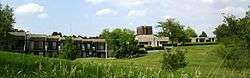
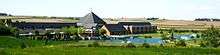
In 1935, monks from the Congregation of Missionary Benedictines of Saint Ottilien established a community in Schuyler as a means of supporting the Congregation's missions in Africa and Asia. At present, Christ the King Priory is home to eleven monks. The monks' apostolate has expanded to providing retreats at the recently constructed Saint Benedict Center, four miles north of Schuyler.[14]
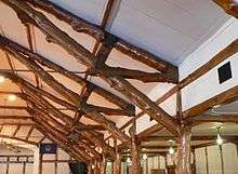
The Oak Ballroom, completed by the Works Progress Administration in 1937 and now listed on the National Register of Historic Places, was built using dozens of native oak trees hauled to the building site from the nearby Platte River using horse and buggies.[15]
Notable people
- Kim Sigler, 40th Governor of Michigan, was born in Schuyler
References
- 1 2 "US Gazetteer files 2010". United States Census Bureau. Retrieved 2012-06-24.
- 1 2 "American FactFinder". United States Census Bureau. Retrieved 2012-06-24.
- ↑ "Population Estimates". United States Census Bureau. Retrieved 2013-05-29.
- ↑ "US Board on Geographic Names". United States Geological Survey. 2007-10-25. Retrieved 2008-01-31.
- ↑ "Find a County". National Association of Counties. Retrieved 2011-06-07.
- ↑ Bain, David Haward (2004). The Old Iron Road: An Epic of Rails, Roads, and the Urge to Go West. New York City, New York: Penguin Books. pp. 65–6. ISBN 0-14-303526-6.
- ↑ "US Gazetteer files: 2010, 2000, and 1990". United States Census Bureau. 2011-02-12. Retrieved 2011-04-23.
- ↑ "Annual Estimates of the Resident Population for Incorporated Places: April 1, 2010 to July 1, 2015". Retrieved July 2, 2016.
- ↑ United States Census Bureau. "Census of Population and Housing". Retrieved October 16, 2013.
- ↑ "Annual Estimates of the Resident Population: April 1, 2010 to July 1, 2012". Retrieved October 16, 2013.
- ↑ "Community Facts: Schuyler, Nebraska". Nebraska Public Power District. October 2009. Retrieved 2010-03-05.
- ↑ "Schuyler, Nebraska". Retrieved 2012-07-09.
- ↑ Olson, James C. (1966). History of Nebraska (Second Edition). Lincoln, Nebraska: University of Nebraska Press. pp. 186–87. ISBN 0-8032-5790-2.
- ↑ The Schuyler Sun, Volume 113 No. 43
- ↑ Nebraska Public Television – Statewide http://net.unl.edu/swi/pers/ballroom.html
Further reading
- James Potter, "A Case Study of the Impact of Population Influx on a Small Community in Nebraska, Great Plains Research, Sept 2004, Vol. 14 Issue 2, pp 219–230
- The Schuyler Sun, A Pictorial History of Schuyler in Observance of the 125th Anniversary, 1995.
External links
Municipalities and communities of Colfax County, Nebraska, United States | ||
|---|---|---|
| Cities | ||
| Villages | ||
| Unincorporated communities | ||