Sematan
| Sematan | |
|---|---|
 Sematan | |
| Coordinates: 1°48′00″N 109°46′00″E / 1.8°N 109.76667°E | |
| Country |
|
| State |
|
| Administrative Division | Lundu |
| Elevation | 1 m (3 ft) |
Sematan (also known as Simatan) is a settlement in the Lundu district of Sarawak, Malaysia.[1][2] It lies approximately 67.5 kilometres (42 mi) west-north-west of the state capital Kuching.
Sematan is a fishing village looking out over the South China Sea. It has reasonably clean beaches, a promenade along the waterfront and a concrete pier into the sea. At the north end there is a park celebrating early Malay fishermen in the Sematan area.[3] Accommodation in Sematan can be had at the Sematan Hotel.[4]
Neighbouring settlements include:
- Kampung Tanah Hitam 0 kilometres (0.0 mi) north
- Kampung Sebat 1.9 kilometres (1.2 mi) west
- Kampung Tembaga 2.6 kilometres (1.6 mi) southwest
- Kampung Perigi 4.1 kilometres (2.5 mi) southeast
- Kampung Seru Laut 5.2 kilometres (3.2 mi) northwest
- Kampung Paon 5.9 kilometres (3.7 mi) south
- Kampung Siru 6.7 kilometres (4.2 mi) northwest
- Kampung Serayan 7.4 kilometres (4.6 mi) south
- Kampung Selarat 7.6 kilometres (4.7 mi) south
- Pelaman Siru 8.3 kilometres (5.2 mi) northwest
Gallery
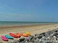 Sematan beach
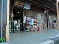 Old shops in Sematan
References
- ↑ M. Mohizah, S. Julia and W. K. Soh (2006). A Sarawak Gazetteer (PDF). Kuala Lumpur: Sarawak Forestry Department Malaysia and Forest Research Institute Malaysia. ISBN 9832181860. OCLC 85818866. Retrieved 2011-01-01.
- ↑ "Sematan, Malaysia". Geonames. 2010-08-09. Retrieved 2010-12-27.
- ↑ Simon Richmond (1 January 2010). Malaysia, Singapore & Brunei. Lonely Planet. pp. 429–. ISBN 978-1-74104-887-2. Retrieved 15 July 2012.
- ↑ Charles De Ledesma; Mark Lewis; Pauline Savage (1 December 2003). Rough Guide to Malaysia, Singapore & Brunei. Rough Guides. pp. 433–. ISBN 978-1-84353-094-7. Retrieved 15 July 2012.
External links
Capital: Kuching | |||||||||||||||||||||||
| Topics |
| ||||||||||||||||||||||
| Society |
| ||||||||||||||||||||||
| Administrative divisions |
| ||||||||||||||||||||||
| |||||||||||||||||||||||
This article is issued from Wikipedia - version of the 10/29/2016. The text is available under the Creative Commons Attribution/Share Alike but additional terms may apply for the media files.