Shade Furnace Archaeological District
|
Shade Furnace Archeological District | |
|
Shade Furnace, 1992 | |
  | |
| Location | North of Rockingham above Dark Shade Creek, Shade Township, Pennsylvania |
|---|---|
| Coordinates | 40°9′11.22″N 78°49′41.88″W / 40.1531167°N 78.8283000°WCoordinates: 40°9′11.22″N 78°49′41.88″W / 40.1531167°N 78.8283000°W |
| Area | 208 acres (84 ha) |
| Architectural style | Other, 19th-century stone blast furnace |
| MPS | Iron and Steel Resources of Pennsylvania MPS |
| NRHP Reference # | 07001380[1] |
| Added to NRHP | January 10, 2008 |
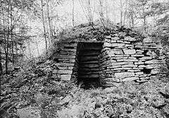
Shade Furnace Archeological District, also known as Old Shade Furnace and Shade Forge, is a national historic district located at Shade Township in Somerset County, Pennsylvania. The district includes four contributing sites and two contributing objects. It encompasses the ruins of a countryside plantation style iron forge operation that operated from 1808 to 1858. It includes a stone blast furnace structure, a forge site, an ore pit site, a farmstead site, and a late 19th-century coal mine complex. The area includes a number of archaeological sites associated with the ruins of abandoned buildings.[2]
It was listed on the National Register of Historic Places in 2008.[1]
References
- 1 2 National Park Service (2010-07-09). "National Register Information System". National Register of Historic Places. National Park Service.
- ↑ "National Historic Landmarks & National Register of Historic Places in Pennsylvania" (Searchable database). CRGIS: Cultural Resources Geographic Information System. Note: This includes Brian L. Fritz (March 2006). "National Register of Historic Places Inventory Nomination Form: Shade Furnace Archeological District" (PDF). Retrieved 2011-12-08.
External links
- Shade Furnace, Our American Heritage website by Richard Parks
- Historic American Engineering Record (HAER) No. PA-374, "Shade Furnace, Reitz, Somerset County, PA", 5 photos, 3 data pages, 1 photo caption page
| Topics |   | |
|---|---|---|
| Lists by county |
| |
| Lists by city | ||
| Other lists | ||
| ||
This article is issued from Wikipedia - version of the 11/28/2016. The text is available under the Creative Commons Attribution/Share Alike but additional terms may apply for the media files.