Shaoshan, Shaoshan
| Shaoshan Township | |
|---|---|
| Township | |
| Chinese transcription(s) | |
| • Simplified | 韶山乡 |
| • Traditional | 韶山鄉 |
| • Pinyin | Sháoshān Xiāng |
 | |
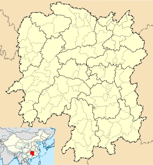 Shaoshan Township Location in Hunan | |
| Coordinates: 27°54′29″N 112°29′12″E / 27.90806°N 112.48667°ECoordinates: 27°54′29″N 112°29′12″E / 27.90806°N 112.48667°E | |
| Country | People's Republic of China |
| Province | Hunan |
| City | Xiangtan |
| County-level city | Shaoshan |
| Area | |
| • Total | 53.24 km2 (20.56 sq mi) |
| Population | 18,626 |
| Time zone | China Standard (UTC+8) |
| Postal code | 411300 |
| Area code(s) | 0732 |
Shaoshan Township (simplified Chinese: 韶山乡; traditional Chinese: 韶山鄉; pinyin: Sháoshān Xiāng) is an rural township in Shaoshan City, Xiangtan City, Hunan Province, China. It is surrounded by Ruyi Town on the northeast, Longdong Township on the south, and Daping Township and Yanglin Township on the west. As of the 2012 census it had a population of 18,626 and an area of 53.24 square kilometres (20.56 sq mi).
Administrative division
The township is divided into ten villages: Shaoshan Village (韶山村), Shaoyuan Village (韶源村), Shaobei Village (韶北村), Tiepi Village (铁皮村), Shaoguang Village (韶光村), Zhuji Village (竹鸡村), Guyang Village (谷阳村), Shitang Village (石塘村), Huaqiao Village (花桥村), Shaoxi Village (韶西村), Shaodong Village (韶东村), Chengqian Village (城前村), and Xinhu Village (新湖村).[1]
Education
There are two junior high schools and three primary schools located with the town.
Attractions

Mao Zedong's Former Residence and Dishui Hole (滴水洞) are famous scenic spots.