Shire of Tambellup
This article is about a local government area. For the town, see Tambellup, Western Australia.
| Shire of Tambellup Western Australia | |||||||||||||
|---|---|---|---|---|---|---|---|---|---|---|---|---|---|
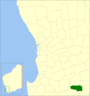 Location in Western Australia | |||||||||||||
| Population | 659 (2006)[1] | ||||||||||||
| • Density | 0.4588/km2 (1.1883/sq mi) | ||||||||||||
| Established | 1905 | ||||||||||||
| Area | 1,436.3 km2 (554.6 sq mi) | ||||||||||||
| Council seat | Tambellup | ||||||||||||
| Region | Great Southern | ||||||||||||
| Website | Shire of Tambellup | ||||||||||||
| |||||||||||||
The Shire of Tambellup was a local government area in the Great Southern region of Western Australia, about 40 kilometres (25 mi) south of Katanning and about 330 kilometres (205 mi) south-southeast of the state capital, Perth. The Shire covered an area of 1,436 square kilometres (554 sq mi), and its seat of government was the town of Tambellup.
The Tambellup Road Board was gazetted in 1905. On 1 July 1961, it became a shire council following changes to the Local Government Act.[2] On 1 July 2008, after 10 months of planning and preparation, it merged with the neighbouring Shire of Broomehill to form the Shire of Broomehill-Tambellup.
Wards
The shire was divided into 3 wards:
- Stirling Ward (3 councillors)
- Toolbrunup Ward (3 councillors)
- Warrenup Ward (3 councillors)
Towns and localities
References
- ↑ Australian Bureau of Statistics (25 October 2007). "Tambellup (S) (Local Government Area)". 2006 Census QuickStats. Retrieved 2 May 2014.
- ↑ WA Electoral Commission, Municipality Boundary Amendments Register (release 2.0), 31 May 2003.
Coordinates: 34°02′28″S 117°38′31″E / 34.041°S 117.642°E
This article is issued from Wikipedia - version of the 4/4/2016. The text is available under the Creative Commons Attribution/Share Alike but additional terms may apply for the media files.