Sims Chapel, Alabama
| Sims Chapel, Alabama | |
|---|---|
| Census-designated place | |
 Sims Chapel, Alabama | |
| Coordinates: 31°13′11″N 88°08′55″W / 31.21972°N 88.14861°WCoordinates: 31°13′11″N 88°08′55″W / 31.21972°N 88.14861°W | |
| Country | United States |
| State | Alabama |
| County | Washington |
| Area[1] | |
| • Total | 5.734 sq mi (14.85 km2) |
| • Land | 5.703 sq mi (14.77 km2) |
| • Water | 0.031 sq mi (0.08 km2) |
| Elevation | 85 ft (26 m) |
| Population (2010)[2] | |
| • Total | 153 |
| • Density | 27/sq mi (10/km2) |
| Time zone | Central (CST) (UTC-6) |
| • Summer (DST) | CDT (UTC-5) |
| Area code(s) | 251 |
| GNIS feature ID | 155628[3] |
Sims Chapel is a census-designated place and unincorporated community in Washington County, Alabama, United States. Its population was 153 as of the 2010 census.[2]
References
- ↑ "US Gazetteer files: 2010, 2000, and 1990". United States Census Bureau. 2011-02-12. Retrieved 2011-04-23.
- 1 2 "American FactFinder". United States Census Bureau. Retrieved 2011-05-14.
- ↑ "Sims Chapel". Geographic Names Information System. United States Geological Survey.
Municipalities and communities of Washington County, Alabama, United States | ||
|---|---|---|
| Towns | 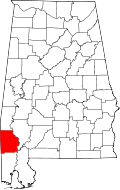 | |
| CDPs | ||
| Unincorporated communities | ||
| Ghost towns | ||
| Footnotes | ‡This populated place also has portions in an adjacent county or counties | |
This article is issued from Wikipedia - version of the 7/31/2014. The text is available under the Creative Commons Attribution/Share Alike but additional terms may apply for the media files.