Sokołów Małopolski
| Sokołów Małopolski | ||
|---|---|---|
|
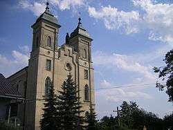
Church in Sokołów Małopolski | ||
| ||
 Sokołów Małopolski | ||
| Coordinates: 50°13′57″N 22°7′15″E / 50.23250°N 22.12083°E | ||
| Country |
| |
| Voivodeship |
| |
| County | Rzeszów | |
| Gmina | Sokołów Małopolski | |
| Government | ||
| • Mayor | Andrzej Mariusz Ożóg | |
| Area | ||
| • Total | 15.55 km2 (6.00 sq mi) | |
| Population (2005) | ||
| • Total | 4,046 | |
| • Density | 260/km2 (670/sq mi) | |
| Time zone | CET (UTC+1) | |
| • Summer (DST) | CEST (UTC+2) | |
| Postal code | 36-050 | |
| Website | http://www.sokolow-mlp.pl | |
Sokołów Małopolski [sɔˈkɔwuf mawɔˈpɔlskʲi] is a town in Rzeszów County, Subcarpathian Voivodeship, Poland, with a population of 3,962 (02.06.2009).[1]
Sokolow Malopolski lies in Sandomierz Basin, 24 kilometers north of Rzeszow, and 11 kilometers from Rzeszów–Jasionka Airport. The history of a forest settlement, located in once mighty Sandomierz Wilderness, dates back to the 14th century. In 1569, Sokolow received town charter, with a Renaissance street plane, and a market square in the centre. In 1608, the town was looted by Stanislaw Stadnicki, a well-known troublemaker and the so-called “Devil of Łańcut”, but after this incident, Sokolow continued to prosper. In 1657, during the Swedish invasion of Poland, Sokolow was destroyed by Transilvanian army of George II Rakoczi.
Following the first partition of Poland, Sokolow was in 1772 annexed by the Habsburg Empire, and remained in Austrian Galicia until late 1918. The town burned in fires in 1863 and 1904, and did not prosper. In the Second Polish Republic, Sokolow belonged to Lwow Voivodeship, and even though it was located in the Central Industrial Region, no plant was opened here, and the promised rail line was not built.
Sokolow has a Renaissance street plane, with a large market square, but due to numerous wars and fires, there are only buildings from the 19th and 20th centuries. In the 17th century, the town was protected by fortifications with five gates and moat. Sokolow has a 17th-century Jewish cemetery, and a parish church (1908–1916).
References
- Notes
- ↑ "Population. Size and structure by territorial division" (PDF). © 1995-2009 Central Statistical Office 00-925 Warsaw, Al. Niepodległości 208. 2009-06-02. Retrieved 2009-06-22. External link in
|publisher=(help)
External links
- Official town webpage
- Old Sokolow Malopolski photographs; taken about 24 years ago.
| Wikimedia Commons has media related to Sokołów Małopolski. |
Coordinates: 50°13′57″N 22°07′15″E / 50.23250°N 22.12083°E
| Town and seat |  | |
|---|---|---|
| Villages | ||