Spivey, Kansas
| Spivey, Kansas | |
|---|---|
| City | |
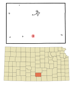 Location within Kingman County and Kansas | |
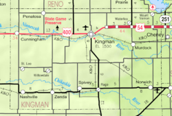 KDOT map of Kingman County (legend) | |
| Coordinates: 37°26′50″N 98°9′50″W / 37.44722°N 98.16389°WCoordinates: 37°26′50″N 98°9′50″W / 37.44722°N 98.16389°W | |
| Country | United States |
| State | Kansas |
| County | Kingman |
| Area[1] | |
| • Total | 0.52 sq mi (1.35 km2) |
| • Land | 0.52 sq mi (1.35 km2) |
| • Water | 0 sq mi (0 km2) |
| Elevation | 1,509 ft (460 m) |
| Population (2010)[2] | |
| • Total | 78 |
| • Estimate (2015)[3] | 76 |
| • Density | 150/sq mi (58/km2) |
| Time zone | Central (CST) (UTC-6) |
| • Summer (DST) | CDT (UTC-5) |
| ZIP code | 67142 |
| Area code | 620 |
| FIPS code | 20-67250 [4] |
| GNIS feature ID | 0470401 [5] |
Spivey is a city in Kingman County, Kansas, United States. As of the 2010 census, the city population was 78.[6]
History
Spivey is the name of Col. E. M. Spivey, member of the town company.[7]
Spivey has had a post office since 1886.[8]
Geography
Spivey is located at 37°26′50″N 98°9′50″W / 37.44722°N 98.16389°W (37.447216, -98.164002).[9] According to the United States Census Bureau, the city has a total area of 0.52 square miles (1.35 km2), all of it land.[1]
Demographics
| Historical population | |||
|---|---|---|---|
| Census | Pop. | %± | |
| 1890 | 205 | — | |
| 1900 | 134 | −34.6% | |
| 1910 | 252 | 88.1% | |
| 1920 | 226 | −10.3% | |
| 1930 | 219 | −3.1% | |
| 1940 | 181 | −17.4% | |
| 1950 | 109 | −39.8% | |
| 1960 | 98 | −10.1% | |
| 1970 | 78 | −20.4% | |
| 1980 | 83 | 6.4% | |
| 1990 | 88 | 6.0% | |
| 2000 | 80 | −9.1% | |
| 2010 | 78 | −2.5% | |
| Est. 2015 | 76 | [3] | −2.6% |
| U.S. Decennial Census | |||
2010 census
As of the census[2] of 2010, there were 78 people, 37 households, and 25 families residing in the city. The population density was 150.0 inhabitants per square mile (57.9/km2). There were 48 housing units at an average density of 92.3 per square mile (35.6/km2). The racial makeup of the city was 96.2% White and 3.8% Native American. Hispanic or Latino of any race were 12.8% of the population.
There were 37 households of which 18.9% had children under the age of 18 living with them, 40.5% were married couples living together, 18.9% had a female householder with no husband present, 8.1% had a male householder with no wife present, and 32.4% were non-families. 32.4% of all households were made up of individuals and 21.6% had someone living alone who was 65 years of age or older. The average household size was 2.11 and the average family size was 2.56.
The median age in the city was 51.5 years. 17.9% of residents were under the age of 18; 1.3% were between the ages of 18 and 24; 21.7% were from 25 to 44; 30.8% were from 45 to 64; and 28.2% were 65 years of age or older. The gender makeup of the city was 50.0% male and 50.0% female.
2000 census
As of the census[4] of 2000, there were 80 people, 37 households, and 25 families residing in the city. The population density was 153.8 people per square mile (59.4/km²). There were 49 housing units at an average density of 94.2 per square mile (36.4/km²). The racial makeup of the city was 100.00% White. Hispanic or Latino of any race were 5.00% of the population.
There were 37 households out of which 27.0% had children under the age of 18 living with them, 56.8% were married couples living together, 5.4% had a female householder with no husband present, and 32.4% were non-families. 32.4% of all households were made up of individuals and 5.4% had someone living alone who was 65 years of age or older. The average household size was 2.16 and the average family size was 2.72.
In the city the population was spread out with 25.0% under the age of 18, 5.0% from 18 to 24, 31.3% from 25 to 44, 23.8% from 45 to 64, and 15.0% who were 65 years of age or older. The median age was 40 years. For every 100 females there were 128.6 males. For every 100 females age 18 and over, there were 122.2 males.
The median income for a household in the city was $37,250, and the median income for a family was $38,125. Males had a median income of $40,625 versus $6,250 for females. The per capita income for the city was $23,849. There were 4.8% of families and 6.6% of the population living below the poverty line, including no under eighteens and 15.0% of those over 64.
References
- 1 2 "US Gazetteer files 2010". United States Census Bureau. Retrieved 2012-07-06.
- 1 2 "American FactFinder". United States Census Bureau. Retrieved 2012-07-06.
- 1 2 "Annual Estimates of the Resident Population for Incorporated Places: April 1, 2010 to July 1, 2015". Retrieved July 2, 2016.
- 1 2 "American FactFinder". United States Census Bureau. Retrieved 2008-01-31.
- ↑ "US Board on Geographic Names". United States Geological Survey. 2007-10-25. Retrieved 2008-01-31.
- ↑ "2010 City Population and Housing Occupancy Status". U.S. Census Bureau. Retrieved March 6, 2011.
- ↑ "Profile for Spivey, Kansas". ePodunk. Retrieved 12 June 2014.
- ↑ "Kansas Post Offices, 1828-1961, page 2 (archived)". Kansas Historical Society. Archived from the original on October 9, 2013. Retrieved 12 June 2014.
- ↑ "US Gazetteer files: 2010, 2000, and 1990". United States Census Bureau. 2011-02-12. Retrieved 2011-04-23.
External links
| Wikimedia Commons has media related to Spivey, Kansas. |
- City
- Schools
- USD 331, local school district
- Maps
- Spivey City Map, KDOT
Municipalities and communities of Kingman County, Kansas, United States | ||
|---|---|---|
| Cities | 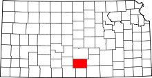 | |
| Unincorporated communities |
| |
| Townships | ||