Sree Kanteerava Stadium
 | |
| Location | Bengaluru, India |
|---|---|
| Coordinates | 12°58′10.40″N 77°35′36.49″E / 12.9695556°N 77.5934694°E |
| Owner | Department of Youth Services & Sports, Karnataka |
| Capacity | 24,000[1] |
| Construction | |
| Built | 1997 |
| General contractor | SVEC Constructions Ltd, Hyderabad |
| Tenants | |
|
India national football team Bengaluru FC (2014–present) | |
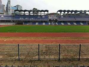
Sree Kanteerava Stadium, also spelled Sri Kanteerava Stadium, is a multi-purpose stadium in Bengaluru, India. It is used mostly for football matches. The stadium holds 24,000 people. It also includes two outdoor rock climbing walls, a running track, a football field and a volleyball court. It is Bengaluru's main sports stadium and several national level teams hold their training sessions here. Years ago, Sree Kanteerava Stadium was a lake. The Sree Kanteerva athletic track was developed into a pro synthetic track for 1997 national games; it was a cinder track before. The athletic track will soon be undergoing renovation. This stadium was constructed through SVEC Constructions Ltd, Hyderabad costing Rs.22 Crores and completed by 31 May 1997.The football field the home ground for Bengaluru Football Club . History was made here when Bengaluru FC defeated JDT to reach the AFC Cup final to be the first Indian football club to do that. Matches of the U17 FIFA World Cup 2017 will be played here!
Central arena
The central arena of the stadium consists of an 8-lane 400m synthetic athletic track, along with synthetic surfaced areas for field events like long jump, high jump, triple jump and pole vault. In-side the athletic tracks lies a Football field 100m x 68m in size.
Entrances
The stadium contains four large arched entrances leading on to the inner field and lower spectator stands. Eight ramps have been provided in the stadium, taking spectators to the upper stands. Thus in total, 12 gates for spectators serve the stadium.
See also
References
External links
| Wikimedia Commons has media related to Sree Kanteerava Stadium. |
Coordinates: 12°58′11″N 77°35′37″E / 12.969671°N 77.593474°E