St. Helens, Oregon
| St. Helens, Oregon | ||
|---|---|---|
| City | ||
|
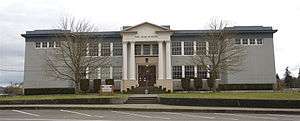
Olde School in St. Helens | ||
| ||
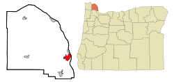 Location in Oregon | ||
| Coordinates: 45°51′34″N 122°49′1″W / 45.85944°N 122.81694°WCoordinates: 45°51′34″N 122°49′1″W / 45.85944°N 122.81694°W | ||
| Country | United States | |
| State | Oregon | |
| County | Columbia | |
| Incorporated | 1889 | |
| Government | ||
| • Mayor | Randy Peterson (D)[1] | |
| Area[2] | ||
| • Total | 5.51 sq mi (14.27 km2) | |
| • Land | 4.53 sq mi (11.73 km2) | |
| • Water | 0.98 sq mi (2.54 km2) | |
| Elevation | 39 ft (11.9 m) | |
| Population (2010)[3] | ||
| • Total | 12,883 | |
| • Estimate (2012[4]) | 12,910 | |
| • Density | 2,843.9/sq mi (1,098.0/km2) | |
| Time zone | Pacific (UTC-8) | |
| • Summer (DST) | Pacific (UTC-7) | |
| FIPS code | 41-64600[5] | |
| GNIS feature ID | 1126468[6] | |
| Website | www.ci.st-helens.or.us | |

St. Helens is the county seat of Columbia County, Oregon. It was founded by Captain H. M. Knighton, a native of New England, in 1845 as "Plymouth". The name was changed to St. Helens in the latter part of 1850 for its view of Mount St. Helens some 39 miles (63 km) away in Washington. The population was 12,883 at the 2010 census.[7]
History
St. Helens was established as a river port on the Columbia River in the 1840s. In 1853, the Pacific Mail Steamship Company tried to make the city their only stop on the Columbia River.[8] Portland's merchants boycotted this effort, and the San Francisco steamship Peytona helped break the impasse.[8]
St. Helens was incorporated as a city in 1889.[9]
The Lewis and Clark Expedition passed through and camped in the area that is now St. Helens on the night of November 5, 1805 while on their way to the Pacific Ocean. While here the party encountered Native Americans and Clark observed "low rockey clifts".[10]
Geography
U.S. Route 30 passes through the city.[11]
According to the United States Census Bureau, the city has a total area of 5.51 square miles (14.27 km2), of which, 4.53 square miles (11.73 km2) is land and 0.98 square miles (2.54 km2) is water.[2]
Climate
According to the Köppen climate classification system, St. Helens has a warm-summer Mediterranean climate (Csb).
| Climate data for St. Helens | |||||||||||||
|---|---|---|---|---|---|---|---|---|---|---|---|---|---|
| Month | Jan | Feb | Mar | Apr | May | Jun | Jul | Aug | Sep | Oct | Nov | Dec | Year |
| Record high °F (°C) | 63 (17) |
71 (22) |
82 (28) |
90 (32) |
102 (39) |
104 (40) |
106 (41) |
107 (42) |
106 (41) |
94 (34) |
72 (22) |
62 (17) |
107 (42) |
| Average high °F (°C) | 46.4 (8) |
51.2 (10.7) |
57.2 (14) |
63.1 (17.3) |
69.4 (20.8) |
75.3 (24.1) |
81.5 (27.5) |
82.4 (28) |
76.6 (24.8) |
65.1 (18.4) |
52.2 (11.2) |
45.7 (7.6) |
63.8 (17.7) |
| Average low °F (°C) | 33.1 (0.6) |
34.4 (1.3) |
38.1 (3.4) |
40.7 (4.8) |
45.7 (7.6) |
51 (11) |
55.1 (12.8) |
55.4 (13) |
51.5 (10.8) |
44.4 (6.9) |
38.2 (3.4) |
33.9 (1.1) |
43.5 (6.4) |
| Record low °F (°C) | 9 (−13) |
4 (−16) |
18 (−8) |
20 (−7) |
21 (−6) |
34 (1) |
38 (3) |
30 (−1) |
34 (1) |
20 (−7) |
10 (−12) |
1 (−17) |
1 (−17) |
| Average precipitation inches (mm) | 6.27 (159.3) |
4.82 (122.4) |
4.71 (119.6) |
3.4 (86) |
2.82 (71.6) |
1.94 (49.3) |
0.72 (18.3) |
1.11 (28.2) |
1.7 (43) |
3.15 (80) |
6.42 (163.1) |
6.75 (171.5) |
43.79 (1,112.3) |
| Average snowfall inches (cm) | 1.3 (3.3) |
0.4 (1) |
0 (0) |
0 (0) |
0 (0) |
0 (0) |
0 (0) |
0 (0) |
0 (0) |
0 (0) |
0.4 (1) |
0.8 (2) |
3 (8) |
| Average precipitation days | 18 | 15 | 17 | 15 | 12 | 9 | 4 | 5 | 7 | 12 | 18 | 18 | 150 |
| Source: [12] | |||||||||||||
Neighborhoods
Columbia Heights is a formerly separate populated place that is within the city limits of St. Helens.[13][14]
Demographics
| Historical population | |||
|---|---|---|---|
| Census | Pop. | %± | |
| 1880 | 209 | — | |
| 1890 | 220 | 5.3% | |
| 1900 | 258 | 17.3% | |
| 1910 | 743 | 188.0% | |
| 1920 | 2,220 | 198.8% | |
| 1930 | 3,994 | 79.9% | |
| 1940 | 4,304 | 7.8% | |
| 1950 | 4,711 | 9.5% | |
| 1960 | 5,022 | 6.6% | |
| 1970 | 6,212 | 23.7% | |
| 1980 | 7,064 | 13.7% | |
| 1990 | 7,535 | 6.7% | |
| 2000 | 10,019 | 33.0% | |
| 2010 | 12,883 | 28.6% | |
| Est. 2015 | 13,158 | [15] | 2.1% |
| Sources:[5][16][17][18][19][20] | |||
2010 census
As of the census[3] of 2010, there were 12,883 people, 4,847 households, and 3,243 families residing in the city. The population density was 2,843.9 inhabitants per square mile (1,098.0/km2). There were 5,154 housing units at an average density of 1,137.7 per square mile (439.3/km2). The racial makeup of the city was 90.3% White, 0.6% African American, 1.6% Native American, 1.3% Asian, 0.3% Pacific Islander, 1.3% from other races, and 4.5% from two or more races. Hispanic or Latino of any race were 6.1% of the population.
There were 4,847 households of which 38.6% had children under the age of 18 living with them, 46.5% were married couples living together, 14.3% had a female householder with no husband present, 6.1% had a male householder with no wife present, and 33.1% were non-families. 26.1% of all households were made up of individuals and 9.9% had someone living alone who was 65 years of age or older. The average household size was 2.59 and the average family size was 3.11.
The median age in the city was 34 years. 27.6% of residents were under the age of 18; 9% were between the ages of 18 and 24; 29.9% were from 25 to 44; 23.3% were from 45 to 64; and 10.2% were 65 years of age or older. The gender makeup of the city was 49.8% male and 50.2% female.
2000 census
As of the census[5] of 2000, there were 10,019 people, 3,722 households, and 2,579 families residing in the city. The population density was 2,305.6 people per square mile (889.3/km²). There were 4,032 housing units at an average density of 927.8 per square mile (357.9/km²). The racial makeup of the city was 92.74% White, 0.34% African American, 1.68% Native American, 0.63% Asian, 0.15% Pacific Islander, 1.35% from other races, and 3.11% from two or more races. Hispanic or Latino of any race were 4.05% of the population. 21.5% were of German, 10.9% English, 9.5% Irish and 9.3% American ancestry according to Census 2000.
There were 3,722 households out of which 39.3% had children under the age of 18 living with them, 51.5% were married couples living together, 12.6% had a female householder with no husband present, and 30.7% were non-families. 24.2% of all households were made up of individuals and 7.9% had someone living alone who was 65 years of age or older. The average household size was 2.65 and the average family size was 3.12.
In the city the population was spread out with 30.2% under the age of 18, 9.0% from 18 to 24, 31.7% from 25 to 44, 19.6% from 45 to 64, and 9.6% who were 65 years of age or older. The median age was 32 years. For every 100 females there were 98.9 males. For every 100 females age 18 and over, there were 96.2 males.
The median income for a household in the city was $40,648, and the median income for a family was $45,548. Males had a median income of $39,375 versus $26,725 for females. The per capita income for the city was $17,237. About 8.7% of families and 11.9% of the population were below the poverty line, including 16.5% of those under age 18 and 4.6% of those age 65 or over.
Tourism
The town is home to sets of many films, including the Disney Channel television film Halloweentown, and the film adaptation of Stephanie Meyer's novel Twilight.[21]
Education
Public schools in St. Helens are served by the St. Helens School District.
Media
The Chronicle is St. Helens' weekly newspaper, published since 1881.[10]
KOHI (AM) is St. Helens' local AM radio station.[22]
Notable people
- Robert Cornthwaite, actor
- Holly Madison, playboy model, reality TV personality on The Girls Next Door and Holly's World
- Rob Mallicoat, baseball player
- Frank A. Moore, Chief Justice of the Oregon Supreme Court
- Katee Sackhoff, actress
- Chris Wakeland,[23] baseball player
Sister city
St. Helens has one sister city:
See also
References
- ↑ "Randy Peterson". Democratic Party of Oregon. Retrieved 2 October 2015.
- 1 2 "US Gazetteer files 2010". United States Census Bureau. Retrieved 21 December 2012.
- 1 2 "American FactFinder". United States Census Bureau. Retrieved 21 December 2012.
- ↑ "Population Estimates". United States Census Bureau. Retrieved 2 June 2013.
- 1 2 3 "American FactFinder". United States Census Bureau. Retrieved 2008-01-31.
- ↑ "US Board on Geographic Names". United States Geological Survey. 2007-10-25. Retrieved 2008-01-31.
- ↑ "State & County QuickFacts: St. Helens (city), Oregon". United States Census Bureau. Retrieved 11 September 2012.
- 1 2 MacColl, E. Kimbark (1979). The Growth of a City: Power and Politics in Portland, Oregon 1915-1950. Portland, Oregon: The Georgian Press. ISBN 0-9603408-1-5.
- ↑ "Incorporated Cities: St. Helens". Oregon Blue Book. Oregon State Archives. Retrieved 19 April 2013.
- 1 2 "Journals of Lewis & Clark". University of Nebraska-Lincoln. Retrieved 6 October 2014.
- ↑ "U.S. 30". Google Maps. Retrieved 19 April 2013.
- ↑ "ST HELENS RFD, OREGON (357466)". Western Regional Climate Center. Retrieved November 18, 2015.
- ↑ "Columbia Heights". Geographic Names Information System. United States Geological Survey. 1994-05-01. Retrieved 2013-04-19.
- ↑ "Columbia Heights". Google Maps. Retrieved 2013-04-19.
- ↑ "Annual Estimates of the Resident Population for Incorporated Places: April 1, 2010 to July 1, 2015". Retrieved July 2, 2016.
- ↑ "Population-Oregon" (PDF). U.S. Census 1910. U.S. Census Bureau. Retrieved 22 November 2013.
- ↑ "Population-Oregon" (PDF). 15th Census of the United States. U.S. Census Bureau. Retrieved 27 November 2013.
- ↑ "Number of Inhabitants: Oregon" (PDF). 18th Census of the United States. U.S. Census Bureau. Retrieved 22 November 2013.
- ↑ "Pennsylvania: Population and Housing Unit Counts" (PDF). U.S. Census Bureau. Retrieved 22 November 2013.
- ↑ "Incorporated Places and Minor Civil Divisions Datasets: Subcounty Population Estimates: April 1, 2010 to July 1, 2012". U.S. Census Bureau. Retrieved 25 November 2013.
- ↑ "'Twilight' descends on St. Helens". South County Spotlight. Pamplin Media Group. 30 October 2009. Retrieved 1 February 2011.
- ↑ "KOHI 1600 AM". KOHI 1600 AM. Retrieved 6 October 2014.
- ↑ Wakeland and Rios IL All-Stars
- ↑ http://www.econ.state.or.us/oregontrade/sistercities.htm
External links
| Wikimedia Commons has media related to St. Helens, Oregon. |
| Wikivoyage has a travel guide for St. Helens (Oregon). |
- City of St. Helens (official website)
- Entry for St. Helens in the Oregon Blue Book
Municipalities and communities of Columbia County, Oregon, United States | ||
|---|---|---|
| Cities | 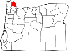 | |
| CDPs | ||
| Other unincorporated communities | ||