Staranzano
| Staranzano | |
|---|---|
| Comune | |
| Comune di Staranzano | |
 Staranzano Location of Staranzano in Italy | |
| Coordinates: 45°48′N 13°30′E / 45.800°N 13.500°ECoordinates: 45°48′N 13°30′E / 45.800°N 13.500°E | |
| Country | Italy |
| Region | Friuli-Venezia Giulia |
| Province / Metropolitan city | Province of Gorizia (GO) |
| Frazioni | Alberoni, Bistrigna, Dobbia, Lido di Staranzano, Quarantia, Villaraspa, Le Coloschie, Bosco Grande, Bonifica del Brancolo, Punta Sdobba |
| Government | |
| • Mayor | Riccardo Marchesan |
| Area | |
| • Total | 18.7 km2 (7.2 sq mi) |
| Elevation | 7 m (23 ft) |
| Population (Dec. 2004) | |
| • Total | 6,812 |
| • Density | 360/km2 (940/sq mi) |
| Demonym(s) | Staranzanesi |
| Time zone | CET (UTC+1) |
| • Summer (DST) | CEST (UTC+2) |
| Postal code | 34079 |
| Dialing code | 0481 |
| Website | Official website |
Staranzano is a comune (municipality) in the Province of Gorizia in the Italian region Friuli-Venezia Giulia, located about 30 kilometres (19 mi) northwest of Trieste and about 15 kilometres (9 mi) southwest of Gorizia. As of 31 December 2004, it had a population of 6,812 and an area of 18.7 square kilometres (7.2 sq mi).[1]
The municipality of Staranzano contains the frazioni (subdivisions, mainly villages and hamlets) Alberoni, Bistrigna, Dobbia, Lido di Staranzano, Quarantia, Villaraspa, Le Coloschie, Bosco Grande, Bonifica del Broncolo and Punta Sdobba.
Staranzano borders the following municipalities: Grado, Monfalcone, Ronchi dei Legionari, San Canzian d'Isonzo.
According to the Italian census of 1971, 3% of the population was of Slovene ethnicity.[2]
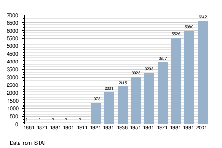
Demographic evolution
References
- ↑ All demographics and other statistics: Italian statistical institute Istat.
- ↑ https://digital.lib.washington.edu/ojs/index.php/ssj/article/viewFile/3423/2836