Stratford, New York
| Stratford, New York | |
|---|---|
| Town | |
|
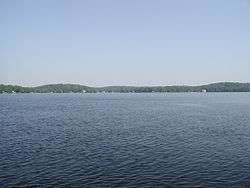
Pleasant Lake, Stratford, NY | |
 Stratford  Stratford | |
| Coordinates: 43°10′45″N 74°39′7″W / 43.17917°N 74.65194°W | |
| Country | United States |
| State | New York |
| County | Fulton |
| Government | |
| • Type | Town Council |
| • Town Supervisor | Robert E. Johnson, Jr. (R) |
| • Town Council |
Members' List
|
| Area | |
| • Total | 76.7 sq mi (198.6 km2) |
| • Land | 74.9 sq mi (193.9 km2) |
| • Water | 1.8 sq mi (4.6 km2) |
| Elevation | 1,506 ft (459 m) |
| Population (2010) | |
| • Total | 610 |
| • Density | 8/sq mi (3.1/km2) |
| Time zone | Eastern (EST) (UTC-5) |
| • Summer (DST) | EDT (UTC-4) |
| ZIP code | 13470 |
| Area code(s) | 315 |
| FIPS code | 36-71784 |
| GNIS feature ID | 0979533 |
| Website |
stratfordny |
Stratford is a town in Fulton County, New York, United States. The population was 610 at the 2010 census.[1] The town is in the northwest corner of the county, northeast of the village of Dolgeville. It was named after Stratford, Connecticut.
History
The town comprises patents of various pre-Revolutionary grants, including part of the extensive land grants of Sir William Johnson. Settlement began around 1800 by settlers from Connecticut. The town was formed in 1805 from the town of Palatine while still part of Montgomery County. Part of the town was removed in 1842 to form part of the town of Caroga.
The population of Stratford was 353 in 1810.
Geography
According to the United States Census Bureau, the town has a total area of 76.7 square miles (198.6 km2), of which 74.9 square miles (193.9 km2) is land and 1.8 square miles (4.6 km2), or 2.34%, is water.[1]
The north town line is the border of Hamilton County, and the west town line is the border of Herkimer County, partially delineated by East Canada Creek. The town is in the Adirondack Park.
New York State Route 29A is an east-west highway in Stratford.
Demographics
| Historical population | |||
|---|---|---|---|
| Census | Pop. | %± | |
| 1820 | 407 | — | |
| 1830 | 552 | 35.6% | |
| 1840 | 500 | −9.4% | |
| 1850 | 801 | 60.2% | |
| 1860 | 1,172 | 46.3% | |
| 1870 | 1,163 | −0.8% | |
| 1880 | 1,066 | −8.3% | |
| 1890 | 997 | −6.5% | |
| 1900 | 830 | −16.8% | |
| 1910 | 607 | −26.9% | |
| 1920 | 453 | −25.4% | |
| 1930 | 384 | −15.2% | |
| 1940 | 401 | 4.4% | |
| 1950 | 464 | 15.7% | |
| 1960 | 421 | −9.3% | |
| 1970 | 495 | 17.6% | |
| 1980 | 625 | 26.3% | |
| 1990 | 586 | −6.2% | |
| 2000 | 640 | 9.2% | |
| 2010 | 610 | −4.7% | |
| Est. 2014 | 593 | [2] | −2.8% |
As of the census[4] of 2000, there were 640 people, 237 households, and 167 families residing in the town. The population density was 8.5 people per square mile (3.3/km²). There were 525 housing units at an average density of 7.0 per square mile (2.7/km²). The racial makeup of the town was 97.19% White, 1.09% African American, 0.47% Native American, 0.31% from other races, and 0.94% from two or more races. Hispanic or Latino of any race were 1.56% of the population.
There were 237 households out of which 31.6% had children under the age of 18 living with them, 54.4% were married couples living together, 8.4% had a female householder with no husband present, and 29.5% were non-families. 23.6% of all households were made up of individuals and 11.0% had someone living alone who was 65 years of age or older. The average household size was 2.64 and the average family size was 3.08.
In the town the population was spread out with 24.2% under the age of 18, 6.4% from 18 to 24, 29.4% from 25 to 44, 26.4% from 45 to 64, and 13.6% who were 65 years of age or older. The median age was 41 years. For every 100 females there were 114.0 males. For every 100 females age 18 and over, there were 115.6 males.
The median income for a household in the town was $27,813, and the median income for a family was $33,125. Males had a median income of $26,103 versus $20,526 for females. The per capita income for the town was $13,120. About 20.1% of families and 24.4% of the population were below the poverty line, including 34.8% of those under age 18 and 6.4% of those age 65 or over.
Communities and locations in Stratford
- Ayers Creek – A stream flowing into the East Canada Creek at Stratford village.
- Ayers Lake – A lake north of Pleasant Lake.
- Bliss Corner – A hamlet southeast of Stratford village. It is named after one of the first settlers.
- Emmonsburg – A hamlet on the west town line by the East Canada Creek, located at the junction of County Roads 104 and 119. The community was formerly known as "Hart's Bridge" and "Whitesburg."
- Knappville – A hamlet north of Stratford village.
- Middle Sprite – A hamlet on the south town line, taking its name from Middle Sprite Creek.
- Oregon – A hamlet in the northwest part of the town, north of Knappville.
- Pleasant Lake – A lake in the eastern part of the town, north of NY-29A.
- Spectacle Lake – An irregularly shaped lake by the north town line.
- Stewart Landing – A hamlet in the southeastern part of the town.
- Stratford – The hamlet of Stratford is located at the west town line on NY-29A. Part of the community is in the town of Salisbury in Herkimer County. It was once called "Deveraux" and "Nicholsville."
References
- 1 2 "Geographic Identifiers: 2010 Census Summary File 1 (G001), Stratford town, Fulton County, New York". American FactFinder. U.S. Census Bureau. Retrieved June 23, 2016.
- ↑ "Annual Estimates of the Resident Population for Incorporated Places: April 1, 2010 to July 1, 2014". Retrieved June 4, 2015.
- ↑ "Census of Population and Housing". Census.gov. Retrieved June 4, 2015.
- ↑ "American FactFinder". United States Census Bureau. Retrieved 2008-01-31.
External links
Coordinates: 43°10′47″N 74°41′49″W / 43.17972°N 74.69694°W
Municipalities and communities of Fulton County, New York, United States | ||
|---|---|---|
| Cities | 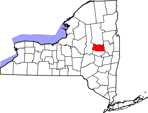 | |
| Towns | ||
| Villages | ||
| CDP | ||
| Other Hamlets | ||
| Footnotes | ‡This populated place also has portions in an adjacent county or counties | |