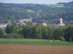
Strmilov
| Strmilov | |||
| Town | |||
 Strmilov | |||
|
|||
| Country | Czech Republic | ||
|---|---|---|---|
| Region | South Bohemian | ||
| District | Jindřichův Hradec | ||
| Commune | Jindřichův Hradec | ||
| Elevation | 545 m (1,788 ft) | ||
| Coordinates | CZ 49°9′52″N 15°12′11″E / 49.16444°N 15.20306°ECoordinates: CZ 49°9′52″N 15°12′11″E / 49.16444°N 15.20306°E | ||
| Area | 30.58 km2 (11.81 sq mi) | ||
| Population | 1,456 (2011-01-01) | ||
| Density | 48/km2 (124/sq mi) | ||
| First mentioned | 1255 | ||
| Mayor | Jaromír Krátký | ||
| Timezone | CET (UTC+1) | ||
| - summer (DST) | CEST (UTC+2) | ||
| Postal code | 378 53 - 378 59 | ||
  Location in the Czech Republic | |||
| Wikimedia Commons: Strmilov | |||
| Statistics: statnisprava.cz | |||
| Website: www.strmilovsko.cz | |||
Strmilov (German: Tremles) is a town in the Czech Republic on the borders of historical border between Moravia and Bohemia.
History
The original settlement was probably established at the beginning of 13th century. The first written information about the town dates back to 1255. In 1945, the German population was expelled according to the Beneš decrees.
Geography
Strmilov is situated along the stream Hamerský potok and uphill on two hills. It is surrounded by fields and forests with several fishponds. In addition to fishing, mushroom picking in the forests is also popular with locals as well as tourists. The Komorník lake between Strmilov and its neighbouring town Kunžak is a summer holiday camping ground.
External links
- Official website (Czech)
| Wikimedia Commons has media related to Strmilov. |
This article is issued from Wikipedia - version of the 4/4/2016. The text is available under the Creative Commons Attribution/Share Alike but additional terms may apply for the media files.