Sturt National Park
| Sturt National Park New South Wales | |
|---|---|
|
IUCN category II (national park) | |
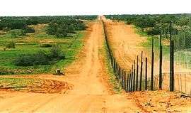 The Dingo Fence in Cameron Corner, located on the northern boundary of the national park | |
 Sturt National Park | |
| Nearest town or city | Tibooburra |
| Coordinates | 29°05′37″S 141°30′31″E / 29.09361°S 141.50861°ECoordinates: 29°05′37″S 141°30′31″E / 29.09361°S 141.50861°E |
| Established | 25 February 1972[1] |
| Area | 3,253.29 km2 (1,256.1 sq mi)[1] |
| Managing authorities | NSW National Parks & Wildlife Service |
| Website | Sturt National Park |
| See also |
Protected areas of New South Wales |
The Sturt National Park is a protected national park that is located in the arid far north-western corner of New South Wales, in eastern Australia. The 325,329-hectare (803,910-acre) national park is situated approximately 1,060 kilometres (660 mi) northwest of Sydney and the nearest town is Tibooburra, 6 kilometres (3.7 mi) away.
Established in 1972, the park is named in honour of Charles Sturt, a colonial explorer. The park features typical outback scenery of flat, reddish-brown landscapes.[2] It was resumed from five pastoral properties.[3] The Sturt National Park was featured in British documentary called Planet Earth. The Dingo Fence was built along the national park's northern boundary.
Flora and fauna
The park contains large populations of both red and western grey kangaroos.[4] Plants consist mostly of mulga bushland and arid shrubland.[3] After good rain the harsh landscape is transformed by the growth of wildflowers including Sturt's desert pea.[5]
Attractions
The park contains aboriginal middens and stone relics.[5] There are many walking trails and an extensive network of roads. Most roads in the park are gravel with some sandy stretches and can be driven on with a conventional vehicle.[5] A 4WD vehicle is needed after heavy rains.
In the east of the park are flood plains, dotted with occasional trees which then give way to small rocky gorges and creek beds. Located here is Mount Wood, Gorge Lookout and the Mount Wood camping ground.[5]
Towards the middle of the park, The Olive Downs, or "Jump Up" country has flat topped mesas rising up to 150 metres (490 ft) above the surrounding plains, granite outcrops and flat valleys.[2] The Jump Ups are the remains of an ancient mountain range.[2] The park's second camping site called Dead Horse Gully camping ground is located here.[5] Amongst the boulders north of Tibooburra is another camping ground. All camp grounds have toilets, gas barbecues and water provided.[3]
In the far west of the national park, the gibber plains are replaced by sandhills of the Strzelecki Desert. Cameron Corner is a remote but popular tourist destination where the states of New South Wales, South Australia and Queensland meet. Also in this part of the park is Fort Grey—the fourth camp ground and a heritage site. The holding yards visible here and a remnant from the explorer Charles Sturt.[5] The fort is a stockade that was built to protect Sturt's supplies and prevent the exploration party's sheep from wandering away.[3] While searching for a fabled inland sea, Captain Charles Sturt, after whom the park is named, spent a year in the area.[5] Fort Grey is sited on the edge of the ephemeral, and Ramsar-listed, Lake Pinaroo - an important breeding and drought refuge for waterbirds when it contains water.[6]
See also
References
- 1 2 "Sturt National Park: Park management". Office of Environment & Heritage. Government of New South Wales. Retrieved 13 October 2014.
- 1 2 3 Pritchard, Chris (7 December 2008). "Corner Country's where three states meet and tourists roam". Courier Mail. Retrieved 5 July 2009.
- 1 2 3 4 "Tibooburra". The Sydney Morning Herald. 1 January 2009. Retrieved 5 July 2009.
- ↑ "Sturt National Park Travel Information and Travel Guide". Lonely Planet Publications. 17 February 2009. Retrieved 5 July 2009.
- 1 2 3 4 5 6 7 Discover Australia's National Parks. Hema Maps. Milsons Point, New South Wales: Random House Australia. 1997. pp. 128–9. ISBN 1-875992-47-2.
- ↑ "Lake Pinaroo (Fort Grey Basin) Ramsar site". Office of Environment & Heritage. Government of New South Wales. 26 October 2012. Retrieved 22 July 2013.
External links
| Wikimedia Commons has media related to Sturt National Park. |
- "Sturt National Park: Plan of management" (PDF). NSW National Parks & Wildlife Service (PDF). Government of New South Wales. February 1996. ISBN 0-7310-0828-6.