Sudbury, Vermont
| Sudbury, Vermont | |
|---|---|
| Town | |
|
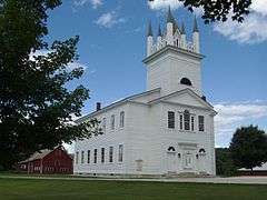
The Sudbury Congregational Church in Sudbury village | |
 Sudbury, Vermont | |
| Coordinates: 43°46′53″N 73°11′16″W / 43.78139°N 73.18778°WCoordinates: 43°46′53″N 73°11′16″W / 43.78139°N 73.18778°W | |
| Country | United States |
| State | Vermont |
| County | Rutland |
| Area | |
| • Total | 22.2 sq mi (57.5 km2) |
| • Land | 21.5 sq mi (55.7 km2) |
| • Water | 0.7 sq mi (1.8 km2) |
| Elevation | 778[1] ft (237 m) |
| Population (2010) | |
| • Total | 560 |
| • Density | 25/sq mi (9.7/km2) |
| Time zone | Eastern (EST) (UTC-5) |
| • Summer (DST) | EDT (UTC-4) |
| ZIP code | 05733 |
| Area code(s) | 802 |
| FIPS code | 50-71050[2] |
| GNIS feature ID | 1462222[3] |
Sudbury is a town in Rutland County, Vermont, United States. The population was 560 at the 2010 census.[4]
Geography
According to the United States Census Bureau, the town has a total area of 22.2 square miles (57 km2), of which 21.5 square miles (56 km2) is land and 0.7 square miles (1.8 km2), or 3.15%, is water.
Demographics
| Historical population | |||
|---|---|---|---|
| Census | Pop. | %± | |
| 1790 | 258 | — | |
| 1800 | 521 | 101.9% | |
| 1810 | 754 | 44.7% | |
| 1820 | 809 | 7.3% | |
| 1830 | 812 | 0.4% | |
| 1840 | 796 | −2.0% | |
| 1850 | 794 | −0.3% | |
| 1860 | 696 | −12.3% | |
| 1870 | 601 | −13.6% | |
| 1880 | 562 | −6.5% | |
| 1890 | 502 | −10.7% | |
| 1900 | 474 | −5.6% | |
| 1910 | 415 | −12.4% | |
| 1920 | 417 | 0.5% | |
| 1930 | 361 | −13.4% | |
| 1940 | 321 | −11.1% | |
| 1950 | 263 | −18.1% | |
| 1960 | 249 | −5.3% | |
| 1970 | 253 | 1.6% | |
| 1980 | 380 | 50.2% | |
| 1990 | 516 | 35.8% | |
| 2000 | 583 | 13.0% | |
| 2010 | 560 | −3.9% | |
| Est. 2014 | 548 | [5] | −2.1% |
| U.S. Decennial Census[6] | |||
As of the census[2] of 2000, there were 583 people, 237 households, and 159 families residing in the town. The population density was 27.1 people per square mile (10.5/km2). There were 373 housing units at an average density of 17.4 per square mile (6.7/km2). The racial makeup of the town was 99.14% White, 0.34% African American, 0.17% Native American, 0.17% Pacific Islander, and 0.17% from two or more races. Hispanic or Latino of any race were 0.69% of the population.
There were 237 households out of which 26.2% had children under the age of 18 living with them, 57.4% were married couples living together, 8.0% had a female householder with no husband present, and 32.9% were non-families. 24.9% of all households were made up of individuals and 5.1% had someone living alone who was 65 years of age or older. The average household size was 2.46 and the average family size was 2.96.
In the town the population was spread out with 22.8% under the age of 18, 5.8% from 18 to 24, 27.8% from 25 to 44, 31.0% from 45 to 64, and 12.5% who were 65 years of age or older. The median age was 42 years. For every 100 females there were 96.3 males. For every 100 females age 18 and over, there were 94.0 males.
The median income for a household in the town was $38,958, and the median income for a family was $47,083. Males had a median income of $33,333 versus $28,558 for females. The per capita income for the town was $18,994. About 3.2% of families and 7.7% of the population were below the poverty line, including 3.0% of those under age 18 and 12.1% of those age 65 or over.
Notable people
- Edwin Atkins Merritt, former New York State Assemblyman and Collector of the Port of New York
References
- ↑ http://vermont.gov/portal/government/towns.php?town=202 Vermont Government Portal indicates only 572 above sea level. Retrieved 24 Sep 2014.
- 1 2 "American FactFinder". United States Census Bureau. Retrieved 2008-01-31.
- ↑ "US Board on Geographic Names". United States Geological Survey. 2007-10-25. Retrieved 2008-01-31.
- ↑ "Profile of General Population and Housing Characteristics: 2010 Demographic Profile Data (DP-1): Sudbury town, Vermont". U.S. Census Bureau, American Factfinder. Retrieved November 4, 2011.
- ↑ "Annual Estimates of the Resident Population for Incorporated Places: April 1, 2010 to July 1, 2014". Retrieved June 4, 2015.
- ↑ "U.S. Decennial Census". United States Census Bureau. Retrieved May 16, 2015.
Municipalities and communities of Rutland County, Vermont, United States | ||
|---|---|---|
| City |  | |
| Towns | ||
| Village | ||
| CDPs | ||
| Other communities | ||