Taghkanic, New York
| Taghkanic, New York | |
|---|---|
| Town | |
|
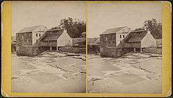
The Old Armory in Taghkanic | |
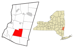 Location of Taghkanic, New York | |
| Coordinates: 42°8′N 73°40′W / 42.133°N 73.667°W | |
| Country | United States |
| State | New York |
| County | Columbia |
| Government | |
| • Type | Town Council |
| • Town Supervisor | Erik Tyree (Independence Party) |
| • Town Council |
Members' List
|
| Area | |
| • Total | 40.2 sq mi (104.0 km2) |
| • Land | 40.0 sq mi (103.5 km2) |
| • Water | 0.2 sq mi (0.4 km2) |
| Elevation | 564 ft (172 m) |
| Population (2010) | |
| • Total | 1,310 |
| • Density | 33/sq mi (12.7/km2) |
| Time zone | Eastern (EST) (UTC-5) |
| • Summer (DST) | EDT (UTC-4) |
| FIPS code | 36-73077 |
| GNIS feature ID | 0979540 |
| Website |
taghkanic |
Taghkanic (/təˈkɑːnᵻk/) is a town in Columbia County, New York, United States. The town is in the south-central part of the county. The population was 1,310 at the 2010 census.[1] "Taghkanic" is an older spelling of "Taconic".
History
Settlement began before 1700 while the region was part of Livingston Manor. The town was formed from the town of Livingston in 1803 as the town of Granger.
Geography
According to the United States Census Bureau, the town has a total area of 40.2 square miles (104.0 km2), of which 40.0 square miles (103.5 km2) is land and 0.15 square miles (0.4 km2), or 0.41%, is water.[1] The town shares its name with Taghkanic Creek, a tributary to Claverack Creek, which runs through the town in a U shape from the northeast corner to the northwest corner. The town also shares its name with the Taghkanic or Taconic Mountains on the eastern part of the township.
The Taconic State Parkway passes through the town.
Demographics
| Historical population | |||
|---|---|---|---|
| Census | Pop. | %± | |
| 1820 | 3,600 | — | |
| 1830 | 1,654 | −54.1% | |
| 1840 | 1,674 | 1.2% | |
| 1850 | 1,539 | −8.1% | |
| 1860 | 1,717 | 11.6% | |
| 1870 | 1,485 | −13.5% | |
| 1880 | 1,308 | −11.9% | |
| 1890 | 1,062 | −18.8% | |
| 1900 | 894 | −15.8% | |
| 1910 | 771 | −13.8% | |
| 1920 | 666 | −13.6% | |
| 1930 | 683 | 2.6% | |
| 1940 | 604 | −11.6% | |
| 1950 | 575 | −4.8% | |
| 1960 | 727 | 26.4% | |
| 1970 | 804 | 10.6% | |
| 1980 | 1,101 | 36.9% | |
| 1990 | 1,111 | 0.9% | |
| 2000 | 1,118 | 0.6% | |
| 2010 | 1,310 | 17.2% | |
| Est. 2014 | 1,303 | [2] | −0.5% |
As of the census[4] of 2000, there were 1,118 people, 461 households, and 325 families residing in the town. The population density was 27.9 people per square mile (10.8/km²). There were 713 housing units at an average density of 17.8 per square mile (6.9/km²). The racial makeup of the town was 98.48% White, 0.63% African American, 0.18% Native American, 0.09% Asian, 0.09% from other races, and 0.54% from two or more races. Hispanic or Latino of any race were 1.07% of the population.
There were 461 households out of which 24.1% had children under the age of 18 living with them, 60.7% were married couples living together, 6.9% had a female householder with no husband present, and 29.5% were non-families. 23.6% of all households were made up of individuals and 9.1% had someone living alone who was 65 years of age or older. The average household size was 2.39 and the average family size was 2.82.
In the town the population was spread out with 20.8% under the age of 18, 3.8% from 18 to 24, 25.8% from 25 to 44, 30.8% from 45 to 64, and 19.0% who were 65 years of age or older. The median age was 45 years. For every 100 females there were 103.6 males. For every 100 females age 18 and over, there were 103.7 males.
The median income for a household in the town was $45,804, and the median income for a family was $51,908. Males had a median income of $31,875 versus $27,375 for females. The per capita income for the town was $29,850. About 6.9% of families and 9.1% of the population were below the poverty line, including 13.0% of those under age 18 and 2.8% of those age 65 or over.
Communities and locations in Taghkanic
- Churchtown – A hamlet at the town line in the northeast part of the town.
- East Taghkanic – A hamlet in the east part of the town, southeast of Taghkanic hamlet.
- Lake Taghkanic State Park – The north part of the state park is at the south town line.
- New Forge – A hamlet in the south part of the town. The House at New Forge was added to the National Register of Historic Places in 1987.[5]
- Taghkanic – The hamlet of Taghkanic is near the center of the town.
- West Taghkanic – A hamlet southwest of Taghkanic hamlet. It was formerly called "Millers Corners" and "Laphams".
References
- 1 2 "Geographic Identifiers: 2010 Demographic Profile Data (G001): Taghkanic town, Columbia County, New York". U.S. Census Bureau, American Factfinder. Retrieved December 11, 2014.
- ↑ "Annual Estimates of the Resident Population for Incorporated Places: April 1, 2010 to July 1, 2014". Retrieved June 4, 2015.
- ↑ "Census of Population and Housing". Census.gov. Retrieved June 4, 2015.
- ↑ "American FactFinder". United States Census Bureau. Retrieved 2008-01-31.
- ↑ National Park Service (2009-03-13). "National Register Information System". National Register of Historic Places. National Park Service.
External links
Coordinates: 42°8′N 73°40′W / 42.133°N 73.667°W
Municipalities and communities of Columbia County, New York, United States | ||
|---|---|---|
| City | 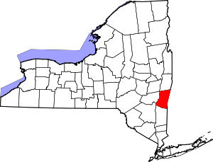 | |
| Towns | ||
| Villages | ||
| CDPs | ||
| Other hamlets | ||
| Footnotes | ‡This populated place also has portions in an adjacent county or counties | |