Tecumseh, Missouri
| Tecumseh, Missouri | |
|---|---|
| Community | |
 Tecumseh, Missouri Location of Tecumseh, Missouri | |
| Coordinates: 36°35′12″N 92°17′12″W / 36.58667°N 92.28667°WCoordinates: 36°35′12″N 92°17′12″W / 36.58667°N 92.28667°W[1] | |
| Country | U. S. A. |
| State | Missouri |
| County | Ozark County |
| Elevation[1] | 180 m (590 ft) |
| Time zone | CST (UTC-6) |
| • Summer (DST) | CDT (UTC-5) |
| Zip Code | 65760 |
Tecumseh is an unincorporated community in eastern Ozark County in southern Missouri.[2] It is located on the North Fork River at the north end of Norfork Lake about ten miles east of Gainesville and 32 miles west of West Plains on U.S. Highway 160.[1] Although it is unincorporated, Tecumseh has a post office with ZIP code 65760.[3]
A post office called Tecumseh has been in operation since 1898.[4] The community was named after Tecumseh, a Shawnee Indian chief.[5][6]
References
- 1 2 3 Udall Quadrangle, Missouri–Ozark County, 7.5 Minute Series, USGS, 1968
- ↑ U.S. Geological Survey Geographic Names Information System: Tecumseh
- ↑ Post Offices in Ozark County, MO
- ↑ "Post Offices". Jim Forte Postal History. Retrieved 27 November 2016.
- ↑ Earngey, Bill (1995). Missouri Roadsides: The Traveler's Companion. University of Missouri Press. p. 97.
- ↑ "Ozark County Place Names, 1928–1945". The State Historical Society of Missouri. Archived from the original on June 24, 2016. Retrieved November 27, 2016.
External links
Municipalities and communities of Ozark County, Missouri, United States | ||
|---|---|---|
| Cities | 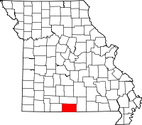 | |
| Villages | ||
| Townships |
| |
| CDPs | ||
| Other unincorporated communities | ||
| Ghost towns | ||
This article is issued from Wikipedia - version of the 11/28/2016. The text is available under the Creative Commons Attribution/Share Alike but additional terms may apply for the media files.