Tecumseh, Nebraska
| Tecumseh, Nebraska | |
|---|---|
| City | |
|
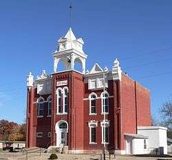
Tecumseh City Hall | |
 Location within Johnson County (left) and Nebraska (right) | |
| Coordinates: 40°22′12″N 96°11′30″W / 40.37000°N 96.19167°WCoordinates: 40°22′12″N 96°11′30″W / 40.37000°N 96.19167°W | |
| Country | United States |
| State | Nebraska |
| County | Johnson |
| Area[1] | |
| • Total | 1.50 sq mi (3.88 km2) |
| • Land | 1.50 sq mi (3.88 km2) |
| • Water | 0 sq mi (0 km2) |
| Elevation | 1,135 ft (346 m) |
| Population (2010)[2] | |
| • Total | 1,677 |
| • Estimate (2012[3]) | 1,661 |
| • Density | 1,118.0/sq mi (431.7/km2) |
| Time zone | Central (CST) (UTC-6) |
| • Summer (DST) | CDT (UTC-5) |
| ZIP code | 68450 |
| Area code(s) | 402 |
| FIPS code | 31-48480[4] |
| GNIS feature ID | 0834057[5] |
| Website | tecumsehne.com |
Tecumseh is a city in and the county seat of Johnson County, Nebraska, United States.[6] The population was 1,677 at the 2010 census.
History
Tecumseh was originally called Frances, and under the latter name was established in 1856.[7] Frances was the name of the wife of Col. Richard M Johnson, the namesake of Johnson County.[8] Shortly after being founded, the name was changed to Tecumseh after the Native American chief said to have been killed by Johnson during the Battle of the Thames. The Nebraska Territorial Legislature established Tecumseh as the county seat in February 1857.[9]
Geography
Tecumseh is located at 40°22′12″N 96°11′30″W / 40.37000°N 96.19167°W (40.370061, -96.191639).[10] According to the United States Census Bureau, the city has a total area of 1.50 square miles (3.88 km2), all of it land.[1]
Demographics
| Historical population | |||
|---|---|---|---|
| Census | Pop. | %± | |
| 1880 | 1,268 | — | |
| 1890 | 1,654 | 30.4% | |
| 1900 | 2,005 | 21.2% | |
| 1910 | 1,748 | −12.8% | |
| 1920 | 1,688 | −3.4% | |
| 1930 | 1,829 | 8.4% | |
| 1940 | 2,104 | 15.0% | |
| 1950 | 1,930 | −8.3% | |
| 1960 | 1,887 | −2.2% | |
| 1970 | 2,058 | 9.1% | |
| 1980 | 1,926 | −6.4% | |
| 1990 | 1,702 | −11.6% | |
| 2000 | 1,716 | 0.8% | |
| 2010 | 1,677 | −2.3% | |
| Est. 2015 | 1,626 | [11] | −3.0% |
2010 census
As of the census[2] of 2010, 1,677 people, 722 households, and 447 families resided in the city. The population density was 1,118.0 inhabitants per square mile (431.7/km2). The 887 housing units averaged 591.3 per square mile (228.3/km2). The racial makeup of the city was 82.5% White, 0.4% African American, 0.1% Native American, 3.2% Asian, 12.9% from other races, and 0.8% from two or more races. Hispanics or Latinos of any race were 16.2% of the population.
Of the 722 households, 27.4% had children under the age of 18 living with them, 48.9% were married couples living together, 9.1% had a female householder with no husband present, 3.9% had a male householder with no wife present, and 38.1% were not families; 33.2% of all households were made up of individuals and 17.6% had someone living alone who was 65 years of age or older. The average household size was 2.25 and the average family size was 2.86.
The median age in the city was 44.8 years; 22.1% of residents were under the age of 18; 6.5% were between the ages of 18 and 24; 21.5% were from 25 to 44; 26.5% were from 45 to 64; and 23.3% were 65 years of age or older. The gender makeup of the city was 47.9% male and 52.1% female.
2000 census
As of the census[4] of 2000, 1,716 people, 729 households, and 446 families resided in the city. The population density was 1,159.5 people per square mile (447.7/km²). The 854 housing units averaged 577.0 per square mile (222.8/km²). The racial makeup of the city was 86.36% White, 0.06% African American, 0.58% Native American, 5.59% Asian, 5.07% from other races, and 2.33% from two or more races. Hispanics or Latinos of any race were 6.53% of the population.
Of the 729 households, 28.8% had children under the age of 18 living with them, 50.9% were married couples living together, 7.0% had a female householder with no husband present, and 38.7% were not families. About 34.6% of all households were made up of individuals, and 21.1% had someone living alone who was 65 years of age or older. The average household size was 2.27 and the average family size was 2.93.
In the city, the population was distributed as 24.0% under the age of 18, 6.1% from 18 to 24, 24.4% from 25 to 44, 20.6% from 45 to 64, and 25.0% who were 65 years of age or older. The median age was 42 years. For every 100 females, there were 82.6 males. For every 100 females age 18 and over, there were 79.9 males.
As of 2000, the median income for a household in the city was $31,844, and for a family was $42,337. Males had a median income of $27,228 versus $19,896 for females. The per capita income for the city was $16,194. About 8.4% of families and 11.9% of the population were below the poverty line, including 17.0% of those under age 18 and 10.1% of those age 65 or over.
In the media
The town was used largely for the setting of the miniseries Amerika, which depicted life in a small American town after a successful takeover by the Soviet Union.
Notable people
- Dennis Aust, baseball player
- Betsy Baker, oldest ever verified person in the world at the time of her death in 1955 at the age of 113
- Tony Davis, professional football player
- Peirson M. Hall, a federal judge who lived in a Tecumseh orphanage
- Walter Kiechel III, managing editor of Fortune magazine, author of The Lords of Strategy, born in Tecumseh
- Virgil A. Martin, Los Angeles, California, City Council member (1927–31), born in Tecumseh
- Ronald Schafer, electrical engineer and author of many textbooks on digital signal processing and audio analysis
- Bob Stitt, head football coach at the University of Montana
See also
References
- 1 2 "US Gazetteer files 2010". United States Census Bureau. Retrieved 2012-06-24.
- 1 2 "American FactFinder". United States Census Bureau. Retrieved 2012-06-24.
- ↑ "Population Estimates". United States Census Bureau. Retrieved 2013-05-29.
- 1 2 "American FactFinder". United States Census Bureau. Retrieved 2008-01-31.
- ↑ "US Board on Geographic Names". United States Geological Survey. 2007-10-25. Retrieved 2008-01-31.
- ↑ "Find a County". National Association of Counties. Retrieved 2011-06-07.
- ↑ Burr, George L.; Buck, O.O. (1921). History of Hamilton and Clay Counties, Nebraska, Volume 1. S.J. Clarke Publishing Company. p. 121.
- ↑ "Tecumseh". Nebraska State Historical Society. Retrieved 14 August 2014.
- ↑ "Tecumseh, Hall County". Center for Advanced Land Management Information Technologies. University of Nebraska. Retrieved 14 August 2014.
- ↑ "US Gazetteer files: 2010, 2000, and 1990". United States Census Bureau. 2011-02-12. Retrieved 2011-04-23.
- ↑ "Annual Estimates of the Resident Population for Incorporated Places: April 1, 2010 to July 1, 2015". Retrieved July 2, 2016.
- ↑ "Census of Population and Housing". Census.gov. Retrieved June 4, 2015.
External links
Municipalities and communities of Johnson County, Nebraska, United States | ||
|---|---|---|
| City | ||
| Villages | ||
| Unincorporated communities | ||