Thanchi Upazila
| Thanchi থানচি | |
|---|---|
| Upazila | |
 Thanchi Location in Bangladesh | |
| Coordinates: 21°47.2′N 92°25.7′E / 21.7867°N 92.4283°ECoordinates: 21°47.2′N 92°25.7′E / 21.7867°N 92.4283°E | |
| Country |
|
| Division | Chittagong Division |
| District | Bandarban District |
| Area | |
| • Total | 1,020.82 km2 (394.14 sq mi) |
| Population (1991) | |
| • Total | 16,104 |
| • Density | 16/km2 (41/sq mi) |
| Time zone | BST (UTC+6) |
| Website | Official Map of Thanchi |
Thanchi (Bengali: থানচি) is an Upazila of Bandarban District in the Division of Chittagong, Bangladesh.[1]
Geography
Thanchi is located at 21°47′10″N 92°25′40″E / 21.7861°N 92.4278°E. It has 2,885 households and a total area of 1020.82 km².
Demographics
According to the 1991 Bangladesh census, Thanchi has a population of 16104. Males constituted 55.61% of the population, and females 44.39%. The population aged 18 or over was 8,639. Thanchi had an average literacy rate of 17.4% (7+ years), against the national average of 32.4%.[2]
Administration
Thanchi has 4 Unions/Wards, 12 Mauzas/Mahallas, and 82 villages.
Gallery
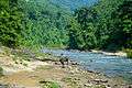 Remakri lake
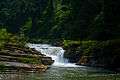 Amiakhum waterfall
 Nafakhum waterfall
See also
References
- ↑ Atikur Rahman (2012). "Thanchi Upazila". In Sirajul Islam and Ahmed A. Jamal. Banglapedia: National Encyclopedia of Bangladesh (Second ed.). Asiatic Society of Bangladesh.
- ↑ "Population Census Wing, BBS.". Archived from the original on 2005-03-27. Retrieved November 10, 2006.
| Upazila/Thana: | ||
|---|---|---|

This article is issued from Wikipedia - version of the 9/29/2016. The text is available under the Creative Commons Attribution/Share Alike but additional terms may apply for the media files.