Thousand Islands


The Thousand Islands constitute an archipelago of 1,864 islands that straddles the Canada–US border in the Saint Lawrence River as it emerges from the northeast corner of Lake Ontario. They stretch for about 50 miles (80 km) downstream from Kingston, Ontario. The Canadian islands are in the province of Ontario and the U.S. islands in the state of New York.
The islands range in size from over 40 square miles (100 km2) to smaller islands occupied by a single residence, or uninhabited outcroppings of rocks. To count as one of the Thousand Islands, emergent land within the river channel must have at least one square foot (0.093 m2) of land above water level year-round, and support at least two living trees.[1][2]
Geography

The Thousand Islands archipelago is located at the outlet of Lake Ontario at the head of the Saint Lawrence River. The region is bisected by the Canada-United States border and covers portions of Jefferson and St. Lawrence counties in the U.S. state of New York, in addition to parts of the United Counties of Leeds and Grenville and Frontenac County in the Canadian province of Ontario.
To be counted an "island" within the Thousand Islands, at least one square foot (0.093 m2) of land must emerge above the river's water level year-round, and the emergent land must support a minimum of two living trees.[1][2] By this definition, the Thousand Islands contains 1,864 islands.
Geologically, the islands are located where a branch of the Canadian Shield runs south across the river to join with the Adirondacks. The Thousand Islands-Frontenac Arch region was designated a World Biosphere Reserve by UNESCO in 2002.[3]
Transportation
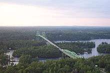
The Thousand Islands Bridge connects New York State and Ontario by traversing Wellesley Island at the northernmost point of Interstate 81 in Jefferson County and meets Highway 137, which leads to Highway 401. The waterfront is served by New York State Routes 12 and 37 and by the Thousand Islands Parkway in Ontario. Ontario also has the Waterfront Trail alongside the Parkway for cyclists who wish to see the area in an alternative way.
Large freighters frequently ply the Saint Lawrence Seaway, but the area has so many shoals and rocks that foreign vessels must use maritime pilots to help them travel through the hazardous waterway.[4] In places, a vessel less than 25 feet (7.6 m) offshore can find itself in over 200 feet (61 m) of water. Conversely, rocks and shoals less than two feet (61 cm) underwater can be found in the center of channels 90 feet (27 m) deep. Due to the great number of rocks and shoals just above or below the water's surface, navigation at night can be dangerous, especially outside of the main channels.
Before the advent of the zebra mussel, visibility of only 10 to 15 feet (3.0 to 4.6 m) was usual, slightly decreasing as the years passed. Water clarity improved markedly in the mid-1990s with the arrival of zebra mussels, which feed on algae. The water is so clear in some areas that a rocky bottom can be observed in 80 feet (24 m) of water. The area has several shipwrecks, and although most of them are over 100 feet (30 m) underwater, some are a mere 15 feet (4.6 m) down and can be seen from the surface.
Notable islands

- The largest island in the group, Wolfe Island, is located entirely in Ontario. Other large islands in the archipelago include New York's Grindstone Island and Wellesley Island, and Ontario's Howe Island.
- Adjacent to Wolfe Island but part of New York is Carleton Island, the site of a ruined fort, Fort Haldimand, built in 1779 by the British during the American Revolutionary War. The island was captured by three American soldiers during the War of 1812 and remains part of the United States today.
- Deer Island, about two miles (3.2 km) north of Alexandria Bay, is owned by the secret society of Skull and Bones.
- A pair of islands southwest of Grenadier Island are collectively called Zavikon Island. A popular but incorrect[5][6] tale is that the larger island is in Canada, while the smaller one is in the United States, and the foot bridge between them is the shortest international bridge in the world.[7][8] Zavikon Island is entirely located in the Canadian territory and belongs to the Leeds and Grenville municipal unit.[9][10]
- Longue Vue Island is the only artificial island in the region.
- Ironsides Island is home to one of the largest Great blue heron rookeries in northern New York State, where over one thousand herons return to breed each April.[11] The uninhabited rocky island near Alexandria Bay, New York is owned by The Nature Conservancy and was listed as a National Natural Landmark in 1967.[12]
- Calumet Island is located near Clayton, New York. The privately owned island formerly featured a "castle" mansion belonging to New York tobacco tycoon Charles G. Emery, and later hosted a marina in the 1960s.[13][14]
History
O boating on the rivers,
The voyage down the St. Lawrence, the superb scenery, the steamers,
The ships sailing, the Thousand Islands, the occasional timber-raft
and the raftsmen with long-reaching sweep-oars,
The little huts on the rafts, and the stream of smoke when they cook
supper at evening.
Walt Whitman, "A Song of Joys", from Leaves of Grass (1855)
Prior to European colonization, the Thousand Islands region was home to, or visited by, members of the Iroquois Confederacy and Ojibwa people. Their name for the islands was Manitouana or the "Garden of the Great Spirit".[15]
The region was a part of the War of 1812 between the British Empire and the United States. Many sites from the war can be found, such as Fort Wellington in Prescott, Ontario and the garrison on Chimney Island, Mallorytown, Ontario. Museums about the war can be found on both the Canadian and American side of the river.
.jpg)
.jpg)
In the late 19th and early 20th centuries, many distinguished visitors made the region widely known as a summer resort. During the half century (1874–1912) of the resort's greatest prominence, most wealthy vacationers came from New York City, joined by prominent families from Chicago, Cleveland, Pittsburgh and other cities of the United States and Canada. Several grand hotels provided luxurious accommodations while steamboats offered extensive tours among the islands. Wealthy and middle-class summer residents built summer homes, and the region retains a historically important collection of vacation homes from this time.
Among the lavish homes built during this time were several masonry "castles", some of which remain as international landmarks. The region's first castle, Castle Rest, was built in 1888; it was destroyed in the mid-20th century.[16] The most famous extant examples are "The Towers" on Dark Island, now called Singer Castle, and the previously long-neglected Boldt Castle on Heart Island, which had been left unfinished for over 75 years upon the untimely death of George Boldt's wife. It has since been completed over the recent decades in accord with Boldt's original plans.
The Thousand Islands have long been a center for recreational boating. Large steam yachts, many designed by Nathanael Herreshoff, required distinctive yacht houses. The region was known also for innovative power boating during this period. Three local yacht clubs hosted the Gold Cup Races of the American Power Boat Association for nine consecutive years.
Recreation
Public parks

Around twenty islands form the Thousand Islands National Park, the oldest of Canada's national parks east of the Rocky Mountains. The park hosts campgrounds, inland walking trails, annual family events, as well as a national heritage building.[17]
Thirty New York state parks are managed as part of the New York State Office of Parks, Recreation and Historic Preservation's Thousand Islands Region,[18] including many that are located on river islands or along the New York shore. Many of these river parks were established in the late 19th and early 20th century as part of the St. Lawrence Reservation,[19] and were among New York's earliest land acquisitions for the purpose of preservation and recreational development.[20] Among the larger parks are Wellesley Island State Park, which includes the largest camping complex in the region,[21] and Robert Moses State Park.
Other boating, fishing and vacationing locations
- One of the few beaches in the Thousand Islands, Potter's Beach (conserved by the Thousand Islands Land Trust) on the American Grindstone Island has a fine, shallow sandy bottom with a very gradual slope, and serves as a location for boats to set anchor and spend a day at the beach or hiking on the trails that extend around Grindstone Island.
- A popular location for swimming or anchoring out of the wind, the Lake of the Isles is a secluded area cut off from the rest of the St. Lawrence River by Wellesley Island and neighboring Canadian Hill Island. Access is limited through two narrow passages, one around the northeastern end of the island, and the other being the International Rift, which is a small, shallow, winding canal that leads you through to the north side of the island passing right underneath the customs bridge.
- Known for its fishing, especially pike, Eel Bay is a shallow bay just southwest of Wellesley Island.
- The Thousand Islands Land Trust (TILT) conserves over 8,500 acres (34 km2) of land in the Thousand Islands region.[22] This land includes many creeks, nature preserves and over 30 miles (48 km) of trails that are open to the public, year-round, free of charge. TILT hosts an annual series of programs – TILTreks, TeenTreks, KidsTreks and TILTKids Camp – that give individuals and families the opportunity to participate in regional field trips, a variety of recreational activities, and attend presentations on wildlife or habitat preservation. TILT's community events help further their conservation efforts in the Thousand Islands region.
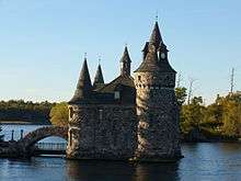
- Boldt Castle, a testament of one man's love of his wife, has been under renovation by its owner, the Thousand Islands Bridge Authority since 1977, and can be visited by boat or tour cruise. This 120-room mansion is located on Heart Island just across the shipping channel from Alexandria Bay. The grounds consist of the main castle, the power house, the play house, and a boat house tucked in across the bay on the inside of the island.

- Though not as famous as George Boldt's Castle, Singer Castle on Dark Island is privately renovated and is open to tourists. Frederick Bourne had his castle constructed with secret passageways and hidden wine cellars so that he could spy on his guests while keeping his liquor out of sight during the prohibition era.
- The Antique Boat Museum in Clayton, New York houses antique wooden boats used or built in the region.[23] The museum also features exhibits on the region's maritime culture and is home to La Duchesse, George Boldt's luxury houseboat.
- The Thousand Islands also facilitates freshwater shipwreck diving. Numerous wrecks lay at the bottom of the seaway including America, Islander, and Keystorm. There are wrecks that are appropriate for all diving skill levels.
Aviation and airports
Passenger air service to the Thousand Islands region is available in both Ontario and New York. Watertown International Airport (ART) in Watertown, New York has daily service on American Airlines connecting through Philadelphia (PHL). Norman Rogers Airport (YGK) in Kingston, Ontario offers daily service on Air Canada connecting through Toronto Pearson. Both airports also offer private aviation services.
Maxson Airfield (FAA LID: 89NY) is a privately owned, private-use general aviation airport located two nautical miles (3.7 km; 2.3 mi) south of the central business district of Alexandria Bay, a village in Jefferson County, New York. It once had commercial service provided by Mohawk Airlines. At that time, the airport bore the IATA airport code AXB. Maxson is available to the public by Maxson Airfield, LLC.
Brockville-Thousand Islands Regional Tackaberry Airport (IATA: XBR, TC LID: CNL3), also known as Brockville Municipal Airport, is a registered aerodrome located in Elizabethtown-Kitley Township, 4.8 nautical miles (8.9 km; 5.5 mi) northwest of the city of Brockville, Ontario, Canada.
Thousand Island dressing
According to The Oxford Companion of Food and Drink, the name for Thousand Island dressing "presumably comes from the Thousand Islands between the United States and Canada in the St. Lawrence River."[24] However, several different versions of the dressing's origin exist.[25] One common story describes how a fishing guide's wife, Sophia LaLonde, made the condiment as part of her husband George's shore dinner.[25] Often in this version, actress May Irwin requested the recipe after enjoying it.[26] Irwin in turn gave it to another Thousand Islands summer resident, George Boldt, who built Boldt Castle between 1900 and 1904. Boldt, as proprietor of the Waldorf-Astoria Hotel, instructed the hotel's maître d'hôtel, Oscar Tschirky, to put the dressing on the menu in 1894.[27][25]
Sociologists attempting to determine the true origin of Thousand Island dressing found that several conflicting origin stories exist, and that they vary between the various islands and villages of the Thousand Islands region. None appear to have any strong written evidence to support their specific claims.[25]
Gallery

 Thousand Islands near Ivy Lea, Ontario
 A house on one of the islands in the region
 Just Room Enough Island
See also
- Amherst Island
- Grenadier Island, New York
- Hochelaga Archipelago
- Murray Isle
- Sugar Island
- Southern Ontario
- Upstate New York
References
- 1 2 Andrea Sachs (September 3, 2010). "Tales of a Thousand Islands". The Washington Post. Retrieved January 30, 2015.
- 1 2 Bartelma, Katy (2005). Let's Go 2005 USA: With Coverage of Canada. New York: St. Martin's Press. p. 270. ISBN 0312335571. Retrieved January 30, 2015.
- ↑ "Frontenac Arch Biosphere". Frontenac Arch Biosphere Network. Retrieved November 26, 2016.
- ↑ "Business And Industry - Pilotage Authorities". Great Lakes St. Lawrence Seaway System. Retrieved May 18, 2015.
- ↑ Clarke, Jay (July 17, 1983). "Retreat to the river on the St. Lawrence islands". The Philadelphia Inquirer. p. I09. Retrieved October 3, 2007.
- ↑ "Shortest International Bridge". Twelve Mile Circle. Retrieved October 15, 2011.
- ↑ Chan, Elise D. (2007). Jefferson County. Arcadia Publishing. p. 58. ISBN 978-0-7385-3547-0.
- ↑ "The Venice of America". The Hindu Business Line. March 13, 2000. Retrieved September 9, 2007.
- ↑ "ONTERM GeoNames Index: Zachary Islands — Zigzag Island". Government of Ontario. Archived from the original on June 11, 2011. Retrieved October 3, 2007.
- ↑ "Natural Resources Canada - Place Names - Zavikon Island". Natural Resources Canada. Retrieved September 17, 2015.
- ↑ "Natural Events Almanac - New York". The Nature Conservancy. Archived from the original on May 17, 2007. Retrieved September 12, 2015.
- ↑ "National Natural Landmark - Ironsides Island". National Park Service. June 28, 2012. Retrieved September 12, 2015.
- ↑ Lunman, Kim (February 13, 2011). "Calumet Island's Lost Castle". Thousand Islands Life. Retrieved September 6, 2016.
- ↑ "1000 Islands - Calumet Island marina in the 1960's". 1000 Islands Boating. Retrieved September 6, 2016.
- ↑ Bell, M.M. (May 1, 2007). "In the River: A Socio-Historical Account of Dialogue and Diaspora". Humanity & Society. 31 (2-3): 210–234. doi:10.1177/016059760703100204. Retrieved November 26, 2016.
- ↑ Malo, Paul (October 12, 2009). "Castle Rest, Its Story". Thousand Islands Life. Retrieved December 2, 2016.
- ↑ "Thousand Islands National Park of Canada - Natural Wonders & Cultural Treasures". Parks Canada. Retrieved May 1, 2015.
- ↑ "Thousand Islands Region". NYS Office of Parks, Recreation & Historic Preservation. Retrieved November 26, 2016.
- ↑ Strough, Arthur B. (January 30, 1902). "The St. Lawrence Reservation or International Park". Seventh Annual Report of the Commissioners of Fisheries, Game and Forests of the State of New York. J.B. Lyon Company, State Printers. pp. 71–86.
- ↑ Natural Heritage Trust; New York State Office of Parks & Recreation; New York State Council of Parks & Recreation (1975). Fifty Years: New York State Parks, 1924-1974. Natural Heritage Trust. pp. 10–12. Retrieved November 24, 2016.
- ↑ "Wellesley Island State Park". NYS Office of Parks, Recreation & Historic Preservation. Retrieved November 26, 2016.
- ↑ "About TILT". Thousand Islands Land Trust. Retrieved November 26, 2016.
- ↑ "Mission & Museum History". Antique Boat Museum. Retrieved November 26, 2016.
- ↑ Smith, Andrew F., ed. (2007). The Oxford Companion of Food and Drink. Oxford University Press US. p. 514. ISBN 978-0-19-530796-2. OCLC 71833329.
- 1 2 3 4 Stiles, Kaelyn; Altıok, Özlem; Bell, Michael M. (March 28, 2010). "The ghosts of taste: food and the cultural politics of authenticity" (PDF). Agriculture and Human Values. 28 (2): 225–236. doi:10.1007/s10460-010-9265-y. Retrieved January 30, 2015.
- ↑ McNeese, Tim (2005). The St. Lawrence River. Infobase Publishing. p. 113. ISBN 978-0-7910-8245-4. OCLC 56591404.
- ↑ "Thousand Island Dressing, Enjoyed around the world and... "Made in Clayton!"". Thousand Islands Inn. Archived from the original on June 27, 2007. Retrieved January 29, 2015.
External links
 Media related to Thousand Islands at Wikimedia Commons
 Thousand Islands travel guide from Wikivoyage
Coordinates: 44°20′N 76°00′W / 44.333°N 76.000°W