Tiversk

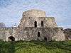
Tiversk or Tiversky gorodok (Russian: Тиверск or Тиверский городок, Finnish: Tiurinlinna) was a medieval Russian fortified settlement 215–300 m. long and 40–56 m. wide in the Karelian Isthmus, near Melnikovo, Leningrad Oblast. It was situated on an island of the River Vuoksi, which became a peninsula after 1857, near rapids.[1]
The fort gained in prominence in 1323 when the Treaty of Nöteborg established a Novgorodian-Swedish border in the immediate vicinity. It was then mentioned in the Nikon Chronicle in 1404, when the settlement was granted to Prince Yury of Smolensk as an appanage. Seven years later, the fort was sacked and destroyed by the Swedes during one of the Swedish-Novgorodian Wars.
The site of Tiversk was first identified and described by Jacob Groot in 1847. The remnants were excavated in 1888-1891 by Hjalmar Appelgren, Theodor Schwindt and Alfred Hackman,[2][3] in 1971 by Anatoly Kirpichnikov, and in 1971-1974 by Svetlana Kochkurkina. Most remnants are dated end of the 13th-beginning of the 15th century. In 1890 archaeological works revealed a treasure trove with 13th-15th century Arabic silver coins. Some remnants dated 10th-early 12th century have also been discovered.[1] The ramparts and stone walls of the settlement were 4.5 to 7 metres thick.[1]
References
| Wikimedia Commons has media related to Tiversk. |
- 1 2 3 Лапшин В. А. Археологическая карта Ленинградской области. Часть 2. Санкт-Петербург: Изд. СПбГУ, 1995. P. 165-167. ISBN 5-87403-052-2
- ↑ Appelgren, Hjalmar. Suomen muinaislinnat. Suomen Muinaismuistoyhdistyksen Aikakauskirja XII. Helsinki, 1891.
- ↑ Schwindt, Theodor. Tietoja Karjalan rautakaudesta. Suomen Muinaismuistoyhdistyksen Aikakauskirja XIII. Helsinki, 1893.