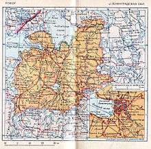
Leningrad Oblast
| Leningrad Oblast Ленинградская область (Russian) | |||
|---|---|---|---|
| — Oblast — | |||
| |||
|
| |||
| |||
|
| |||
| Political status | |||
| Country | Russia | ||
| Federal district | Northwestern[2] | ||
| Economic region | Northwestern[3] | ||
| Established | August 1, 1927[4] | ||
| Seat of government | St. Petersburg[5] | ||
| Government (as of October 2014) | |||
| • Governor[6] | Alexander Drozdenko[7] | ||
| • Legislature | Legislative Assembly[8] | ||
| Statistics | |||
| Area (as of the 2002 Census)[9] | |||
| • Total | 84,500 km2 (32,600 sq mi) | ||
| Area rank | 38th | ||
| Population (2010 Census)[10] | |||
| • Total | 1,716,868 | ||
| • Rank | 26th | ||
| • Density[11] | 20.32/km2 (52.6/sq mi) | ||
| • Urban | 65.7% | ||
| • Rural | 34.3% | ||
| Population (January 2014 est.) | |||
| • Total | 1,763,900[12] | ||
| Time zone(s) | MSK (UTC+03:00)[13] | ||
| ISO 3166-2 | RU-LEN | ||
| License plates | 47 | ||
| Official languages | Russian[14] | ||
| Official website | |||
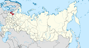
Leningrad Oblast (Russian: Ленингра́дская о́бласть, tr. Leningradskaya oblast’; IPA: [lʲɪnʲɪnˈgratskəjə ˈobləsʲtʲ]) is a federal subject of Russia (an oblast). It was established on August 1, 1927, although it was not until 1946 that the oblast's borders had been mostly settled in their present position. The oblast was named after the city of Leningrad (now St. Petersburg).
The oblast overlaps the historic region of Ingria and is bordered by Finland in the northwest, Estonia in the west, as well as five federal subjects of Russia: the Republic of Karelia in the northeast, Vologda Oblast in the east, Novgorod Oblast in the south, Pskov Oblast in the southwest, and the federal city of Saint Petersburg in the west.
The first governor of Leningrad Oblast was Vadim Gustov (in 1996–1998). The current governor, since 2012, is Alexander Drozdenko.
The oblast has an area of 84,500 square kilometers (32,600 sq mi) and a population of 1,716,868 (2010 Census);[10] up from 1,669,205 recorded in the 2002 Census.[15] The most populous town of the oblast is Gatchina, with 88,659 inhabitants (as of the 2002 Census).[15] Leningrad Oblast is highly industrialized.
Geography
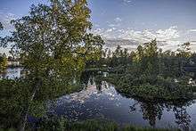
Leningrad Oblast is located around the Gulf of Finland and south of two great lakes of the European Part of Russia, Lake Ladoga and Lake Onega. Its northeastern part, between the Gulf of Finland and Lake Ladoga, occupies the Karelian Isthmus. Some islands in the Gulf of Finland (including Kotlin, on which the city of Kronstadt has been built) and Lake Ladoga (including Konevets) also belong to the oblast.
Much of the area of the oblast belongs to the drainage basin of the Neva, which is the only outflow of Lake Ladoga. Whereas the Neva, which flows to the Gulf of Finland (the city of Saint Petersburg is located in its river delta) is relatively short, its drainage basin is enormously big and includes Lake Onega and Lake Ilmen as well. The Svir and the Volkhov flow from Lake Onega and Lake Ilmen, respectively, to lake Ladoga. Other major tributaries of Lake Ladoga include the Vuoksi and the Syas. Rivers in the western part of the oblast flow to the Gulf of Finland; the two biggest rivers there are the Luga and the Narva, which makes the state border between Russia and Estonia. Minor areas in the east of the oblast belong to the river basin of the Chagodoshcha, a tributary of the Mologa, and of the Suda, both in the basin of the Volga. Thus, the divide between the basins of the Baltic and Caspian Seas crosses the oblast.
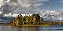
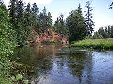
The Karelian Isthmus is a rocky terrain which hosts a lake district. The biggest lakes on the Karelian Isthmus are Lake Vuoksa, Lake Sukhodolskoye, and Lake Otradnoye. The rest of the area of the oblast is essentially flat. The exception is the Tikhvin Ridge, a chain of hills in the east of the oblast. Most of the area is covered by forests and swamps.
Leningrad Oblast contains two nature protected areas at the federal level, the Nizhnesvirsky Nature Reserve and Mshinskoye Boloto Zakaznik, both created to protect forest and swamp landscapes of northwestern Russia.
Flora
The most taxonomically diverse vascular plant families are Asteraceae, Cyperaceae, Poaceae and Rosaceae. By far the most diverse genus is Carex (68 species). The diversity in genera Hieracium (with Pilosella), Ranunculus (with Batrachium), Alchemilla, Galium, Potamogeton, Salix, Veronica, Viola, Juncus, Artemisia, Potentilla, Rumex, Festuca, Epilobium, Poa, Trifolium, Campanula, Vicia, Lathyrus, Geranium is also considerable. The territory has no endemic plant taxa. Vascular plant species of Leningrad Oblast listed in the red data book of Russia are Botrychium simplex, Cephalanthera rubra, Cypripedium calceolus, Epipogium aphyllum, Lobelia dortmanna, Myrica gale, Ophrys insectifera, Orchis militaris, Pulsatilla pratensis, Pulsatilla vernalis.
History
Pre-Leningrad Oblast
The territory of present-day Leningrad Oblast was populated shortly after the end of the Weichsel glaciation and now hosts numerous archaeological remnants.[16][17][18] The Volga trade route and trade route from the Varangians to the Greeks crossed the territory. Staraya Ladoga, the first capital of legendary Rurik, founded in the 8th-9th century, is situated in the east of the oblast, on the Volkhov River.
In the 12th-15th century, the territory was divided between the Kingdom of Sweden and Novgorod Republic (see Swedish-Novgorodian Wars) and mostly populated mostly by various Baltic Finns people such as Karelians (northwest), Izhorians and Votes (west), Vepsians (east), as well as Ilmen Slavs of Novgorod (south). During the Russo-Swedish Wars of the 15th-17th centuries, the border moved back and forth over the land.
The central part of the territory is known as the historical region of Ingria (or the land of Izhora) and in the 17th century, after most of the present-day territory of Leningrad Oblast was captured by Sweden with the Treaty of Stolbovo of 1617, became subject to substantial Finnish Lutheran population influx from Finnish Karelia (which included Karelian Isthmus, the northwestern part of present-day Leningrad Oblast) and Savonia. Ingrian Finns soon became the dominant ethnic group.
During the Great Northern War (1700–1721) the territory of what is now Leningrad Oblast was returned from Sweden by Russia under Peter the Great, who founded Saint Petersburg amidst the land in 1703, which soon became the capital of the Russian Empire. In 1708, most of the territory was organized into Ingermanland Governorate under Governor General Alexander Menshikov. It was renamed Saint Petersburg Governorate in 1710 (the borders of that governorate, however, differed very significantly from those of the present-day oblast and included much of the areas of current Novgorod, Pskov, and Vologda Oblasts). In 1721, the territorial concessions of Sweden were confirmed with the Treaty of Nystad.
The life of the countryside was greatly influenced by the vicinity of the imperial capital, which became a growing market for its agricultural production as well as the main consumer of its mineral and forest resources. In 1719–1810, Ladoga Canal was dug between the Svir River and the Neva River as part of the Volga-Baltic waterway to bypass stormy waters of Lake Ladoga. Since the advent of the rail transport in the late 19th century, the areas in the vicinity of Saint Petersburg had been a popular summer resort destinations (dachas) for its residents. However, while Saint Petersburg itself from the very beginning was populated mostly by Russians, it was not until the 20th century that its surrounding population was Russified.
In 1914, with the beginning of World War I, Saint Petersburg was renamed Petrograd and the governorate was accordingly renamed Petrograd Governorate. After the Russian Revolution, in 1918, the capital was transferred from Petrograd to Moscow, farther from the borders of the country. In 1919, during the Russian Civil War, the Northwestern White Army advancing from Estonia and led by Nikolai Yudenich tried to capture Petrograd and even managed to reach its southern outskirts, but the attack against the Red Army under Leon Trotsky ultimately failed, and Yudenich retreated back. The border with Estonia was established in the Russian-Estonian Treaty of Tartu of 1920. Ingrian Finns of North Ingria attempted to secede in 1918–1920, but were incorporated back with the Russian-Finnish Treaty of Tartu, which settled the border between Finland and Soviet Russia. In 1924, Petrograd was renamed Leningrad and Petrograd Governorate was again renamed accordingly (Leningrad Governorate).
Leningrad Oblast
Leningrad Oblast was established on August 1, 1927 by the resolutions of the All-Russian Central Executive Committee "On the Establishment of Leningrad Oblast" and "On the Borders and Composition of the Okrugs of Leningrad Oblast"[4] by merging Cherepovets, Leningrad, Murmansk, Novgorod, and Pskov Governorates. The territory of the oblast corresponded to the modern territories of the present-day Leningrad Oblast (with the exception of the Karelian Isthmus and the territories along the border with Estonia), Novgorod Oblast, Pskov Oblast, parts of Vologda Oblast, most of Murmansk Oblast, and the federal city of Saint Petersburg. The total area of the oblast was 360,400 square kilometres (139,200 sq mi);[19] more than four times larger than the modern entity. Administratively, the oblast was divided into nine okrugs (Borovichi, Cherepovets, Leningrad, Lodeynoye Pole, Luga, Murmansk, Novgorod, Pskov, and Velikiye Luki), each of which was in turn subdivided into districts.[19]
In 1929, Velikiye Luki Okrug was transferred to newly formed Western Oblast. Leningrad was administratively separated from Leningrad Oblast in December 1931. In 1935 five southernmost districts were made part of Kalinin Oblast. In 1936 some parts of the territory of Leningrad Suburban District of Leningrad was returned to Leningrad Oblast and divided into Vsevolozhsky District, Krasnoselsky District, Pargolovsky District and Slutsky District (renamed Pavlovsky District in 1944). Vologda Oblast, which has included the easternmost districts of Leningrad Oblast (former Cherepovets Governorate), was created in 1937. Murmansk Oblast was split from Leningrad Oblast in 1938.
In the fall of 1934, the Forbidden Border Zone along the western border of the Soviet Union was established, where nobody could appear without special permission issued by the NKVD. It was officially only 7.5 km deep initially, but along the Estonian border it extended to as much as 90 km. The zone was to be free of Finnic and some other peoples, who were considered politically unreliable.[20][21] Starting from the 1929, the Soviet authorities carried out mass deportations of the Ingrian Finnish population of the oblast, which constituted majority in many rural localities as late as in the beginning of the century, to the east, replacing them with people from other parts of the Soviet Union.
On November 30, 1939, the Soviet Union waged the Winter War against neighboring Finland and with the Moscow Peace Treaty in 1940 gained some territories, including Karelian Isthmus. Their Karelian population was hastily evacuated to inner Finland and later replaced with people from other parts of the Soviet Union. A small part of the territory (the municipalities of Kanneljärvi, Koivisto and Rautu) was incorporated into Leningrad Oblast, the rest being included within the Karelo-Finnish Soviet Socialist Republic.
In 1941, Germany invaded the Soviet Union in the Operation Barbarossa, and shortly thereafter the territory became place of the Battle of Leningrad. Wehrmacht captured the southwestern part of the oblast and reached Tikhvin in the east, while Finnish troops quickly recaptured the ceded territories in the Continuation War, encircling Leningrad from the land. In 1944 Soviet offensives managed to expel Wehrmacht and put military pressure on Finland, which ceded Karelian Isthmus again with the Moscow Armistice of September 19, 1944. This time the gained territories of the isthmus was incorporated within Leningrad Oblast (Vyborgsky and Priozersky Districts). In 1947 the territorial gains were confirmed with the Paris Peace Treaty. Novgorod and Pskov Oblasts were formed out of the southern parts of Leningrad Oblast in 1944. In January 1945 a small part of the Estonian SSR to the east of the River Narva with the town of Jaanilinn (now Ivangorod) was transferred to the Russian SFSR and incorporated into Leningrad Oblast. Since then, the territory of Leningrad Oblast hasn't changed much, although some suburbs of Leningrad (now Saint Petersburg) have been excluded from the oblast and incorporated into the city.[22] In October 1946 Leningrad gained from the oblast some former Finnish territories along the northern coast of the Gulf of Finland divided into Sestroretsky District and Kurortny District, including the town of Terijoki.
In 1953, Pavlovsky District of the oblast was abolished, and parts of its territory including Pavlovsk were made subordinate to Leningrad. In 1954 the settlements Levashovo, Pargolovo and Pesochny were also transferred to Leningrad. In 1956 Boksitogorsky District of Leningrad Oblast gained a small territory of Novgorod Oblast. Uritsk was transferred from the oblast to the city of Leningrad in 1963, Krasnoye Selo and several settlements nearby—in 1973, Lomonosov—in 1978.
After a referendum in 1991, the city of Leningrad was renamed back to Saint Petersburg, but Leningrad Oblast retained its name.
First secretaries of the Leningrad Oblast CPSU Committee
In the period when they were the most important authority in the oblast (1927 to 1991), the following first secretaries were appointed,[23]
- 1927-1934 Sergey Mironovich Kirov, assassinated
- 1934-1945 Andrey Andreyevich Zhdanov
- 1945-1946 Alexey Alexandrovich Kuznetsov, subsequently executed
- 1946-1949 Pyotr Sergeyevich Popkov, subsequently executed
- 1949-1953 Vasily Mikhaylovich Andrianov
- 1953-1957 Frol Romanovich Kozlov
- 1957-1962 Ivan Vasilyevich Spiridonov
- 1962-1970 Vasily Sergeyevich Tolstikov
- 1970-1983 Grigory Vasilyevich Romanov
- 1983-1985 Lev Nikolayevich Zaykov
- 1985-1989 Yury Filippovich Solovyov
- 1989-1991 Boris Veniaminovich Gidaspov
Governors
Since 1991, governors were sometimes appointed, and sometimes elected,[24]
- 1991-1996 Alexander Semyonovich Belyakov, head of the administration, appointed;
- 1996-1998 Vadim Anatolyevich Gustov, governor, elected;
- 1998-2012 Valery Pavlovich Serdyukov, governor, elected, then appointed;
- 2012- Alexander Yuryevich Drozdenko, appointed.[25]
Administrative divisions
Administratively, Leningrad Oblast is divided into seventeen districts and a town of oblast significance, Sosnovy Bor. Lomonosovsky District is the only one in Russia which has its administrative center (the town of Lomonosov) located in the area of a different subject of Russian Federation (the federal city of Saint Petersburg, which is not a part of Leningrad Oblast). In terms of the area, the biggest administrative district is Podporozhsky District (7,706 square kilometres (2,975 sq mi)); the smallest one is Lomonosovsky District (1,919 square kilometres (741 sq mi)).
Demographics

Population: 1,716,868 (2010 Census);[10] 1,669,205 (2002 Census);[28] 1,661,173 (1989 Census).[29]
- Vital statistics for 2012
2009 - 1.18 | 2010 - 1.17 | 2011 - 1.16 | 2012 - 1.22 | 2013 - 1.23 | 2014 - 1.28 | 2015 - 1.29(e)
Leningrad Oblast currently has the lowest fertility rate in all of Russia. While birth rates have risen considerably elsewhere, they have remained stuck at a very low level in Leningrad Oblast.
Ethnic groups: according to the 2010 Census, the ethnic composition was:[10]
- Russian 92.7%
- Ukrainian 2%
- Belarusians 1.1%
- Tatar 0.5%
- Armenian 0.4%
- Uzbek 0.4%
- Azeri 0.3%
- Finnish 0.3%
- Romani 0.2%
- Tajik 0.2%
- Moldovan 0.2%
- Veps 0.1%
- others 1.6%
- 114,747 people were registered from administrative databases, and could not declare an ethnicity. It is estimated that the proportion of ethnicities in this group is the same as that of the declared group.[32]
Religion
According to a 2012 official survey[26] 55.1% of the population of Leningrad Oblast adheres to the Russian Orthodox Church, 4% are unaffiliated generic Christians, 1% are Muslims, 1% of the population adheres to the Slavic native faith (Rodnovery), 1% are Old Believers. In addition, 20% of the population declared to be "spiritual but not religious", 8% is atheist, and 9.9% follows other religions or did not give an answer to the question.[26]
Economy
Industry
The oblast, particularly the areas adjacent to Saint Petersburg, is heavily industrialized. The major enterprises include the oil refinery in Kirishi, the Ford car assembly plant and the Rexam PLC Beverage Can Europe and Asia packaging plant in Vsevolozhsk, the paper mill in Syssstroy, and the paper mill and the plant producing oil platforms in Vyborg, and the Tikhvin industrial site in Tikhvin.
Agriculture
The main agricultural specializations of the oblast ate cattle breeding with meat and milk production, as well as poultry production. The main agricultural lands are in the east and in the southwest of the oblast.
Transportation
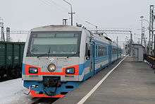
Saint-Petersburg is a major railway hub, and all railways running to it cross also Leningrad Oblast. They connect Saint-Petersburg with Moscow (Saint Petersburg – Moscow Railway), Helsinki via Vyborg, Murmansk via Petrozavodsk, Sortavala via Priozersk, Tallinn via Kingisepp, Riga via Pskov, Vitebsk via Dno, and Veliky Novgorod. There is a network of railways at the Karelian Isthmus, in particular, connecting Vyborg and Priozersk, as well as south of Saint-Petersburg. There also railway lines connecting Veymarn with Gdov via Slantsy, Veymarn with Petergof via Sosnovy Bor, Mga with Sonkovo via Kirishi, Volkhov with Vologda via Tikhvin and Cherepovets, Volkhov with Chudovo, and Lodeynoye Pole with Sortavala via Olonets. Most of them support intensive passenger and cargo traffic.
The western and the central parts of Leningrad Oblast are well covered by paved roads. The M10 highway connects Saint Petersburg with Moscow via Veliky Novgorod in the south and with the Finnish border, continuing across the border to Helsinki, in the north. It is split between European routes E18 (Saint Petersburg to Finland) and E105 (Saint Petersburg to Moscow), and much of it within the oblast is built as a dual carriageway. R21 highway (also part of E105) runs from Saint Petersburg to Murmansk via Petrozavodsk, and A180 (part of E20) connects Saint Petersburg with Ivangorod and continues across the Estonian border to Tallinn. R23 connects Saint Petersburg with Pskov; it is a part of the E95. A114 runs to Vologda via Cherepovets. A paid motorway between Saint Petersburg and Moscow in under construction. Roads are well served by bus traffic.
The Luga, the Svir, the Volkhov, and the Neva are all navigable and heavily user for cargo transport, however, there is no passenger navigation within the oblast. The Onega Canal, shared with Vologda Oblast, serves as a bypass of Lake Onega from the south. Similarly, the Ladoga Canal bypasses Lake Ladoga from the east, from the Svir to the Neva. It is a part of the Volga–Baltic Waterway. In contrast, the Tikhvinskaya water system, connecting the Syas and the Mologa, which provided access from the Ladoga to the river basin of the Volga, is disused. The trans-border Saimaa Canal connects Lake Saimaa in Finland with the Gulf of Finland, has special status, and is occasionally used for passenger navigation.
Ust-Luga, Vyborg, Vysotsk, and Primorsk are the major sea terminals on the Gulf of Finland.
Energy
.JPG)
The Leningrad Nuclear Power Plant is located in the city of Sosnovy Bor. There are four major hydroelectric plants in the oblast. The Volkhov Hydroelectric Station, on the Volkhov River, was constructed in 1921 and became the first major hydropower station in the Soviet Union. The others are the Upper Svir Hydroelectric Station and the Lower Svir Hydroelectric Station, both on the Svir River, and the Narva Hydroelectric Station on the Narva River.
Science and High-tech
There is a fair amount of science and high-tech institutions around Saint Petersburg, some of which are located in the oblast. For example, Gatchina is the site of the Petersburg Nuclear Physics Institute.[33] and Sosnovy Bor hosts the Research Institute of Optical and Electronic Devices.
Culture and recreation
Architecture
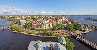
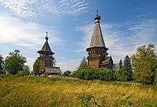
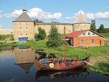
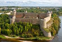
The Volkhov and the Neva Rivers were constituents of major trade routes since prehistory, and their banks are dotted by archaeological sites. Staraya Ladoga has a number of pre-1700 sites, including two of about a couple of dozens standing pre-Mongol churches in Russia. Both of them were built in the 1160s. The Oreshek Fortress in Shlisselburg and the Koporye Fortress, both built in the 14th century, and the Ivangorod Fortress, originally built in 1492, are excellent examples of Russian fortification art. Podporozhsky District contains the best samples of wooden ecclesiastical architecture in Leningrad Oblast, some of which are collectively referred to as Podporozhye Ring: The Resurrection Church in the settlement of Vazhiny, the Saint Nicholas Church in the village of Soginitsy, the Sts Peter and Paul Chapel in the village of Zaozerye, and the Saint Athanasy chapel in the village of Posad. The two other notable wooden churches are located in the villages of Gimreka and Shcheleyki close to the Onega Lake shore. The center of Vyborg preserves many examples of medieval Swedish architecture, unique for Russia.
After Saint Petersburg was founded in 1703, many estates and residences were founded around he city. Some of them still stand and are listed as World Heritage sites, aggregated into the site of Historic Centre of Saint Petersburg and Related Groups of Monuments. includes, among others, estates in Gostilitsy, Ropsha, and Taytsy.
Localities in the Karelian Isthmus preserve some fine inter-war Finnish architecture. The best known example is the Viipuri Municipal Library by Alvar Aalto.
Twin regions
 Aarhus Municipality, Denmark
 South Chungcheong Province, South Korea
 Kyoto Prefecture, Japan
 Lombardy, Italy
 Lower Silesian Voivodeship, Poland
 Nordland, Norway (from 1987)
References
Notes
- ↑ Article 8 of the Charter of Leningrad Oblast states that the oblast may have an anthem, providing a law is adopted to that effect. A contest was held in April 2014 and a winner was selected; however, as of October 2014, no law is officially in place.
- ↑ Президент Российской Федерации. Указ №849 от 13 мая 2000 г. «О полномочном представителе Президента Российской Федерации в федеральном округе». Вступил в силу 13 мая 2000 г. Опубликован: "Собрание законодательства РФ", №20, ст. 2112, 15 мая 2000 г. (President of the Russian Federation. Decree #849 of May 13, 2000 On the Plenipotentiary Representative of the President of the Russian Federation in a Federal District. Effective as of May 13, 2000.).
- ↑ Госстандарт Российской Федерации. №ОК 024-95 27 декабря 1995 г. «Общероссийский классификатор экономических регионов. 2. Экономические районы», в ред. Изменения №5/2001 ОКЭР. (Gosstandart of the Russian Federation. #OK 024-95 December 27, 1995 Russian Classification of Economic Regions. 2. Economic Regions, as amended by the Amendment #5/2001 OKER. ).
- 1 2 Administrative-Territorial Division of Murmansk Oblast, pp. 33–34
- ↑ According to Article 13 of the Charter of Leningrad Oblast, the government bodies of the oblast are located in the city of St. Petersburg. However, neither St. Petersburg nor any other locality is officially named to be the administrative center of the oblast.
- ↑ Charter of Leningrad Oblast, Article 18
- ↑ Official website of Leningrad Oblast. Alexander Yuryevich Drozdenko, Governor of Leningrad Oblast (Russian)
- ↑ Charter of Leningrad Oblast, Article 25
- ↑ Федеральная служба государственной статистики (Federal State Statistics Service) (2004-05-21). "Территория, число районов, населённых пунктов и сельских администраций по субъектам Российской Федерации (Territory, Number of Districts, Inhabited Localities, and Rural Administration by Federal Subjects of the Russian Federation)". Всероссийская перепись населения 2002 года (All-Russia Population Census of 2002) (in Russian). Federal State Statistics Service. Retrieved 2011-11-01.
- 1 2 3 4 Russian Federal State Statistics Service (2011). "Всероссийская перепись населения 2010 года. Том 1" [2010 All-Russian Population Census, vol. 1]. Всероссийская перепись населения 2010 года (2010 All-Russia Population Census) (in Russian). Federal State Statistics Service. Retrieved June 29, 2012.
- ↑ The density value was calculated by dividing the population reported by the 2010 Census by the area shown in the "Area" field. Please note that this value may not be accurate as the area specified in the infobox is not necessarily reported for the same year as the population.
- ↑ Saint Petersburg and Leningrad Oblast Territorial Branch of the Federal State Statistics Service. Население (Russian)
- ↑ Правительство Российской Федерации. Федеральный закон №107-ФЗ от 3 июня 2011 г. «Об исчислении времени», в ред. Федерального закона №271-ФЗ от 03 июля 2016 г. «О внесении изменений в Федеральный закон "Об исчислении времени"». Вступил в силу по истечении шестидесяти дней после дня официального опубликования (6 августа 2011 г.). Опубликован: "Российская газета", №120, 6 июня 2011 г. (Government of the Russian Federation. Federal Law #107-FZ of June 31, 2011 On Calculating Time, as amended by the Federal Law #271-FZ of July 03, 2016 On Amending Federal Law "On Calculating Time". Effective as of after sixty days following the day of the official publication.).
- ↑ Official on the whole territory of Russia according to Article 68.1 of the Constitution of Russia.
- 1 2 Russian Federal State Statistics Service (May 21, 2004). "Численность населения России, субъектов Российской Федерации в составе федеральных округов, районов, городских поселений, сельских населённых пунктов – районных центров и сельских населённых пунктов с населением 3 тысячи и более человек" [Population of Russia, Its Federal Districts, Federal Subjects, Districts, Urban Localities, Rural Localities—Administrative Centers, and Rural Localities with Population of Over 3,000] (XLS). Всероссийская перепись населения 2002 года [All-Russia Population Census of 2002] (in Russian). Retrieved August 9, 2014.
- ↑ Лапшин В. А. "Археологическая карта Ленинградской области. Часть 1: Западные районы". Ленинград, 1990.
- ↑ Лапшин В. А. "Археологическая карта Ленинградской области. Часть 2: Восточные и северные районы". Санкт-Петербург: Изд. СПбГУ, 1995. ISBN 5-87403-052-2.
- ↑ Лебедев Г. С. "Археологические памятники Ленинградской области". Ленинград: Лениздат, 1977.
- 1 2 Administrative-Territorial Division of Leningrad Oblast, p. 10
- ↑ Matley, Ian M. (1979). "The Dispersal of the Ingrian Finns". Slavic Review. 38 (1): 1–16. doi:10.2307/2497223. ISSN 0037-6779. JSTOR 2497223 – via JSTOR. (registration required (help)).
- ↑ Martin, Terry (1998). "The Origins of Soviet Ethnic Cleansing". The Journal of Modern History. University of Chicago Press. 70 (4): 813–61. doi:10.1086/235168. ISSN 1537-5358. JSTOR 10.1086/235168 – via JSTOR. (registration required (help)).
- ↑ Ленинградская область в целом: Административно-территориальное деление Ленинградской области
- ↑ Справочник по истории Коммунистической партии и Советского Союза 1898 - 1991 (in Russian). knowbysight.info. Retrieved 15 August 2014.
- ↑ Губернаторы Ленинградской области (in Russian). ProTown.ru. Retrieved 18 August 2014.
- ↑ "Medvedev Appoints Buryatia, Leningrad Region Governors". The Moscow Times. 5 May 2012. Retrieved 18 August 2014.
- 1 2 3 Arena - Atlas of Religions and Nationalities in Russia. Sreda.org
- ↑ 2012 Survey Maps. "Ogonek", № 34 (5243), 27/08/2012. Retrieved 24-09-2012.
- ↑ Russian Federal State Statistics Service (May 21, 2004). "Численность населения России, субъектов Российской Федерации в составе федеральных округов, районов, городских поселений, сельских населённых пунктов – районных центров и сельских населённых пунктов с населением 3 тысячи и более человек" [Population of Russia, Its Federal Districts, Federal Subjects, Districts, Urban Localities, Rural Localities—Administrative Centers, and Rural Localities with Population of Over 3,000] (XLS). Всероссийская перепись населения 2002 года [All-Russia Population Census of 2002] (in Russian). Retrieved August 9, 2014.
- ↑ Demoscope Weekly (1989). "Всесоюзная перепись населения 1989 г. Численность наличного населения союзных и автономных республик, автономных областей и округов, краёв, областей, районов, городских поселений и сёл-райцентров" [All Union Population Census of 1989: Present Population of Union and Autonomous Republics, Autonomous Oblasts and Okrugs, Krais, Oblasts, Districts, Urban Settlements, and Villages Serving as District Administrative Centers]. Всесоюзная перепись населения 1989 года [All-Union Population Census of 1989] (in Russian). Институт демографии Национального исследовательского университета: Высшая школа экономики [Institute of Demography at the National Research University: Higher School of Economics]. Retrieved August 9, 2014.
- ↑ http://www.gks.ru/free_doc/2012/demo/edn12-12.htm
- ↑ http://www.gks.ru/wps/wcm/connect/rosstat_main/rosstat/ru/statistics/publications/catalog/doc_1137674209312
- ↑ http://www.perepis-2010.ru/news/detail.php?ID=6936
- ↑ "Petersburg Nuclear Physics Institute. National Research Centre "Kurchatov Institute"". pnpi.spb.ru. Retrieved November 6, 2015.
Sources
- Закон №6-оз от 27 октября 1994 г. «Устав Ленинградской области», в ред. Закона №103-оз от 27 декабря 2013 г. «О внесении изменения в областной Закон "Устав Ленинградской области"». Вступил в силу со дня официального публикования. Опубликован: "Вестник Правительства Ленинградской области", №1, 12 января 1995 г. (Law #6-oz of October 27, 1994 Charter of Leningrad Oblast, as amended by the Law #103-oz of December 27, 2013 On Amending the Oblast Law "Charter of Leningrad Oblast". Effective as of the official publication date.).
- Архивный отдел Администрации Мурманской области. Государственный Архив Мурманской области. (1995). Административно-территориальное деление Мурманской области (1920–1993 гг.). Справочник. Мурманск: Мурманское издательско-полиграфическое предприятие "Север".
- В. В. Груздев и А. Т. Русов (1973). Административно-территориальное деление Ленинградской области. Ленинград: Лениздат.
Further reading
Nature
- Айрапетьянц А.Э., Стрелков П.П., Фокин И.М. Звери. [Природа Ленинградской области]. Leningrad: Лениздат, 1987.
- Балашова Н.Б., Никитина В.Н. Водоросли [Природа Ленинградской области]. Leningrad: Лениздат, 1989. ISBN 5-289-00344-4
- Биоразнообразие Ленинградской области (Водоросли. Грибы. Лишайники. Мохообразные. Беспозвоночные животные. Рыбы и рыбообразные) / Под. ред. Н.Б.Балашовой, А.А.Заварзина. - (Труды Санкт-Петербургского общества естествоиспытателей. Серия 6. Том 2.). – Saint Petersburg: Изд-во СПб. университета, 1999.
- Бобров Р.В. Леса Ленинградской области. Leningrad: Лениздат, 1979.
- Бродский А.К., Львовский А.Л. Пауки, насекомые [Природа Ленинградской области]. Leningrad: Лениздат, 1990. ISBN 0528900617
- Иллюстрированный определитель растений Ленинградской области / Под ред. А. Л. Буданцева, Г. П. Яковлева. Moscow: КМК, 2006. ISBN 5-87317-260-9
- Кириллова М.А., Распопов И.М. Озера Ленинградской области. Leningrad: Лениздат, 1971.
- Красная Книга природы Ленинградской области. Том 1. Особо охраняемые природные территории. Отв. ред. Г.А. Носков, М. С. Боч [Red Data Book of Nature of the Leningrad Region. Vol. 1. Protected Areas]. Saint Petersburg: Акционер и К, 1998. ISBN 5-87401-072-6
- Красная Книга природы Ленинградской области. Том 2. Растения и грибы. Отв. ред. Г.А. Носков [Red Data Book of Nature of the Leningrad Region. Vol. 2. Plants and Fungi]. Saint Petersburg: Мир и Семья, 2000. ISBN 5-94365-001-6
- Красная Книга природы Ленинградской области. Том 3. Животные. Отв. ред. Г.А. Носков [Red Data Book of Nature of the Leningrad Region. Vol. 3. Animals]. Saint Petersburg: Мир и Семья, 2002. ISBN 5-94365-021-0
- Леса Ленинградской области: современное состояние и пути их возможного развития. Saint Petersburg, 1998. ISBN 5-230-10457-0
- Мальчевский А. С., Пукинский Ю. Б. Птицы Ленинградской области и сопредельных территорий. История, биология, охрана. Т.1-2. Leningrad: Изд-во ЛГУ, 1983.
- Наумов Н.А. Флора грибов Ленинградской области. Том 1. Архимицеты и фикомицеты [The Fungus Flora of the Leningrad Region. Vol. 1. Archimycetes, Phycomycetes]. Moscow – Leningrad: Изд-во АН СССР, 1954.
- Наумов Н.А. Флора грибов Ленинградской области. Том 2 [The Fungus Flora of the Leningrad Region. Vol. 2]. Moscow – Leningrad: Наука, 1964.
- Неелов, А.В. Рыбы [Природа Ленинградской области]. Leningrad: Лениздат, 1987.
- Покровская Г.В., Бычкова А.Т. Климат Ленинграда и его окрестностей. Leningrad: Гидрометеоиздат, 1967.
- Природа Ленинградской области и ее охрана / Ред. Т.И. Миронова, Э.И. Слепян. - Leningrad: Лениздат, 1983.
- Пукинский Ю. Б. Птицы [Природа Ленинградской области]. Leningrad: Лениздат, 1988.
- Свидерская М.Д., Храбрый В.М. Сохраним для потомков: Особо охраняемые природные территории Ленинградской области. Leningrad: Лениздат, 1985.
- Старобогатов Я.И. Раки, моллюски [Природа Ленинградской области]. Leningrad: Лениздат, 1988. ISBN 5-289-00125-5
- Филимонов Р.В., Удалов С.Г. Жуки-усачи Ленинградской области. Атлас-определитель. [Longhorn Beetles of the St. Petersburg Region: An Identification Atlas]. Saint Petersburg: Петроглиф, 2001. ISBN 5-902094-05-4
- Флора Ленинградской области / Под ред. Б. К. Шишкина. Вып. 1-4. Leningrad: Изд. ЛГУ, 1955–1965.
- Хазанович К. К. Геологические памятники Ленинградской области. Leningrad: Лениздат, 1982.
- Черепанова Н.П., Пшедецкая Л.И. Грибы. [Природа Ленинградской области]. Leningrad: Лениздат, 1990.
History
- Лапшин В. А. Археологическая карта Ленинградской области. Часть 1: Западные районы. Leningrad, 1990.
- Лапшин В. А. Археологическая карта Ленинградской области. Часть 2: Восточные и северные районы. Saint Petersburg: Изд. СПбГУ, 1995. ISBN 5-87403-052-2
- Лебедев Г. С. Археологические памятники Ленинградской области. Leningrad: Лениздат, 1977.
External links
| Wikimedia Commons has media related to Leningrad Oblast. |
- Official website of Leningrad Oblast
- (Russian) Official website of Leningrad Oblast
- (Russian) Detailed and historical maps
 |
|
|
|
|
| |
|
| ||
| ||||
| | ||||
| Pskov Oblast | |
| |||||||||||||||||||||||||||||||
| |||||||||||||||||||||||||||||||