Točná
| Točná | |
| Cadastral subdivision of Prague 12 | |
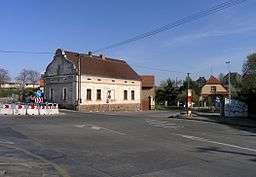 Antonín Pecák square in Točná | |
| Official name: Točná | |
| Country | Czech Republic |
|---|---|
| Region | Prague, the Capital City |
| Coordinates | 49°58′22″N 14°25′55″E / 49.97278°N 14.43194°ECoordinates: 49°58′22″N 14°25′55″E / 49.97278°N 14.43194°E |
| Area | 4.63 km2 (2 sq mi) |
| Population | 750 (31. 12. 2015[1]) |
| Density | 162/km2 (420/sq mi) |
| Founded | 1850 |
| Timezone | CET (UTC+1) |
| - summer (DST) | CEST (UTC+2) |
| Postal code | 143 00 |
 Location of Točná in Prague | |
Točná (German: Totschna) is a village, and a cadastral subdivision of the municipal district of Prague 12. There are 31 streets and 413 addresses registered, and a population of 679.
The village lies just north of Prague's southern border, formed by the Břežaný valley, south-west of Cholupice, north-west of the municipality of Dolní Břežany. Between Točná and the Vltava river to the west is a protected forest. A recreational airport is located within the northern part of the village limits, near the area called Nouzov. The northern part of the village limits are bisected by Prague's Outer Ring Road, which then submerges into a tunnel just south of the airport.
Bus line 173 terminates in the village, and line 341 passes it.
The village has a football pitch, home of the TJ Točná football club. It also has a nursery school, one of the largest second-hand clothing stores in Prague, three automotive repair shops and a garden centre. In 2014, a pub, Hospoda na Točné, opened on Branišovská street.
History
From its formation in 1850, Točná was part of the political municipality of Komořany. It has belonged to the estate of Komořany since the times when Komořany belonged the Zbraslav monastery. Točná became an independent municipality, detaching from Komořany, after World War II. At that time, the municipality of Točná included parts of Komořany. Starting in 1947, the local government of Modřany sought the transfer of the territory of Točná to Modřany.[2] In 1960, the municipality of Točná was merged into the municipality of Cholupice.[3] In 1974, Cholupice was joined to the Capital City of Prague. In 1976, the local government in in Cholupice was dissolved, and both villages were attached to the local government in Modřany,[4] which is now part of Prague 12. A remnant of the local government (Czech: Místního národního výbor, "local national committee") in Točná is the street K výboru ("towards the committee"), which was named in 1974.
Točná Airport
The airport (ICAO code LKTC) opened as a recreational glider airport on March 31, 1946.[5]
After 1989, the runway was shortened to 550 meters due to disputes with landowners.[6]
In 2008, the airport was purchased by Ivo Lukačovič.[7] The service buildings were rebuilt, the property secured by a fence, a museum and public playground were added, and the runway was lengthened to 870 meters.
Protected Forest
The hilly, forested area to the west of the village, bordered by the Břežaný creek, and the communities of Závist, Komořany and Nouzov, is a protected habitat. The vague outlines of a celtic oppidum are visible in the high area called Šance. A large plaque commemorating the entomologist František Antonín Nickerl overlooks the Břežaný valley. The forest's steep trails have, in recent years, become popular amonst mountain bikers.
The forest is bisected by the Branišovská switchback, which is limited to light vehicle traffic. Despite traversing a protected area, the road has been used several times as part of a rally race from Zbraslav to Točná.
Community Events
The village celebrates several annual events:
- January 6 - Three Kings - a charity collection drive organized by the Catholic church, in which donators are rewarded with a chalk inscription of 'K+M+B' (from the names of the Biblical Magi)) above a doorway or on a fencepost
- Lent - Carnival - a charity collection drive organized by the local football club, involving a costume parade
- Spring - Welcoming of Spring - a pageant put on by the local nursery school, culminating in the sybolic drowning of Moréna, an effigy of winter
- Mid-June - St. Anthony's Fair - an all-day event featuring exhibitions, rides, contests and raffles, and live music, organized by the local community association
- Early September - Iron Kelt - a race uphill in the protected forest, 330m long with a rise of 40m
- November 11 - St. Martin's Day - St. Martin, a roman soldier, arrives on a horse, and shares his cloak with a beggar; the gathered crowd then parades through the village behind St. Martin, chanting; the parade terminates in an open field, where poppy-seed pastries are handed out, and everyone is encouraged to share the pastry with another attendee, following the example of St. Martin
- Advent - a pageant put on by the local nursery school, followed by the lighting of the village Christmas tree
Photo Gallery
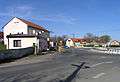 Točná's bus stop
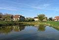 Village pond
.jpg) Cross and bell in the village square
Cross and bell in the village square.jpg) Memorial on the corner of K Výboru and Ke Spálence streets
Memorial on the corner of K Výboru and Ke Spálence streets.jpg) Memorial oak tree in the fields between Točná and Cholupice
Memorial oak tree in the fields between Točná and Cholupice.jpg) Memorial oak trees on the corner of Branišovská and K Výboru streets
Memorial oak trees on the corner of Branišovská and K Výboru streets Prague Točná Airport
Famous Residents
- Jiří Kodet - Czech actor
- Karel Vítězslav Mašek – Czech painter
- Jiří Tichota – Czech musician
References
- ↑ "Obyvatelstvo a rozloha katastrálních území Prahy 2001–2015". Czech Statistical Office. 2016-06-08.
- ↑ Antonín Vlček: Kronika města Modřany, okres Praha-západ, za léta 1945–1964, I. část, 1968-03-06
- ↑ M. Lašťovka, V. Ledvinka et al.: Pražský uličník – Encyklopedie názvů pražských veřejných prostranství, 2. díl (O–Ž), Libri, Praha, 1998, p. 263, keyword „Točenská“
- ↑ Jan Mareš: Praha 12-Modřany, Kronika, volební období 1981–1985, MNV Praha-Modřany, chapter Vývoj zemědělství v Modřanech, source: Pamětní kniha MNV Točná
- ↑ Antonín Vlček: Kronika města Modřany, okres Praha-západ, za léta 1945–1964, I. část, 1968-03-06, p. 142
- ↑ http://www.tocna.cz/historie-letiste/
- ↑ http://ekonomika.idnes.cz/miliardar-lukacovic-chce-z-letiste-tocna-udelat-muzeum-pgp-/ekonomika.aspx?c=A081212_222633_eko_profily_dp
- This article was initially translated from the Czech Wikipedia.