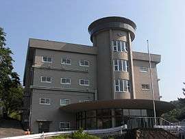
Toba, Mie
| Toba 鳥羽市 | |||
|---|---|---|---|
| City | |||
|
Overview of Toba | |||
| |||
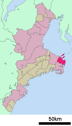 Location of Toba in Mie Prefecture | |||
 Toba
| |||
| Coordinates: 34°28′52.8″N 136°50′36.3″E / 34.481333°N 136.843417°ECoordinates: 34°28′52.8″N 136°50′36.3″E / 34.481333°N 136.843417°E | |||
| Country | Japan | ||
| Region | Kansai, Tōkai | ||
| Prefecture | Mie Prefecture | ||
| Government | |||
| • -Mayor | Kusuichi Kida | ||
| Area | |||
| • Total | 107.34 km2 (41.44 sq mi) | ||
| Population (August 2015) | |||
| • Total | 19,227 | ||
| • Density | 179/km2 (460/sq mi) | ||
| Time zone | Japan Standard Time (UTC+9) | ||
| City symbols | |||
| - Tree | Tachibana | ||
| - Flower | Dianthus | ||
| - Bird | Common gull | ||
| Phone number | 0599-25-1112 | ||
| Address | 3-1-1 Toba, Toba-shi, Mie-ken 517-0011 | ||
| Website |
www | ||


Toba (鳥羽市 Toba-shi) is a city located in Mie Prefecture, Japan.
As of August 2015, the city had an estimated population of 19,227 and a population density of 179 persons per km2. The total area was 107.34 square kilometres (41.44 sq mi).
Geography
Toba is located on the northern half of Shima Peninsula in far eastern Mie Prefecture, facing Ise Bay of the Pacific Ocean. The area is famous for oysters and for cultured pearls. Much of the city is within the borders of the Ise-Shima National Park.
Toba administers numerous islands in the Ise Bay, the most important of which are:
Neighboring municipalities
Mie Prefecture
History
The area of modern Toba has been continuously inhabited since before the Jomon period. During the Sengoku period, the area was under the control of pirates, from whom emerged Kuki Yoshitaka (from Nakiri district) as a dominant ruler. After having dominated the local seacoasts, he established Toba as his capital and built a castle there. Under the Tokugawa shogunate, the castle became the center for Toba Domain.
In the Edo period, Toba flourished in trade and as a transshipment port between Osaka and Edo. The modern city of Toba was formed on November 1, 1954, by the merger of the town of Toba with five villages in Shima District.
Transportation
Railway
Highway
Ferry
Economy
Commercial fishing and cultivated pearls, together with tourism, form the backbone of the local economy.
Education
- Toba National College of Maritime Technology is one of the five maritime technology colleges in Japan and offers merchant marine programs such as Deck officer, Marine Engineering and other advanced programs related to maritime education.[1]
- Toba has ten elementary schools, five middle schools and one high school.
Climate
| Climate data for Toba (1981 - 2010) | |||||||||||||
|---|---|---|---|---|---|---|---|---|---|---|---|---|---|
| Month | Jan | Feb | Mar | Apr | May | Jun | Jul | Aug | Sep | Oct | Nov | Dec | Year |
| Average high °C (°F) | 9.0 (48.2) |
9.5 (49.1) |
13.0 (55.4) |
18.6 (65.5) |
22.7 (72.9) |
25.9 (78.6) |
29.8 (85.6) |
31.0 (87.8) |
27.4 (81.3) |
21.9 (71.4) |
16.6 (61.9) |
11.7 (53.1) |
19.76 (67.57) |
| Average low °C (°F) | 1.7 (35.1) |
1.8 (35.2) |
4.4 (39.9) |
9.3 (48.7) |
13.9 (57) |
18.2 (64.8) |
22.4 (72.3) |
23.5 (74.3) |
20.4 (68.7) |
14.6 (58.3) |
8.9 (48) |
3.9 (39) |
11.92 (53.44) |
| Average precipitation mm (inches) | 77.1 (3.035) |
95.1 (3.744) |
182.8 (7.197) |
203.0 (7.992) |
260.2 (10.244) |
266.6 (10.496) |
197.8 (7.787) |
205.2 (8.079) |
397.4 (15.646) |
257.6 (10.142) |
148.3 (5.839) |
68.3 (2.689) |
2,359.4 (92.89) |
| Mean monthly sunshine hours | 159.8 | 156.4 | 172.5 | 179.2 | 176.4 | 140.5 | 174.2 | 198.1 | 143.5 | 151.3 | 153.9 | 166.4 | 1,972.2 |
| Source: Japan Meteorological Agency (JMA)[2] | |||||||||||||
Local attractions
Sister city relations
 - Santa Barbara, California, since 1966.[3]
 - Sanda, Hyōgo, Friendship city since July 1, 1971
Noted people from Toba
- Mikimoto Kōkichi – Entrepreneur and businessman
- Mitsuru Hattori – Manga artist
External links
| Wikimedia Commons has media related to Toba, Mie. |
-
 Toba travel guide from Wikivoyage
 - Official website (Japanese)
- A Day Tripper's Guide to Ise and Toba Japanzine by Zack Davisson
References
- ↑ Marine Programs in Toba
- ↑ "気象庁|過去の気象データ検索". Retrieved 2014-12-26.
- ↑ "City of Toba". Sister Cities International.
| Special city | ||
|---|---|---|
| Cities | ||
| Kuwana District | ||
| Inabe District | ||
| Mie District | ||
| Taki District | ||
| Watarai District | ||
| Kitamuro District | ||
| Minamimuro District | ||