Torgau-Oschatz
| Torgau-Oschatz | |
|---|---|
| District | |
 | |
| Country |
|
| State | Saxony |
| Adm. region | Leipzig |
| Disbanded | 2008-08-01 |
| Capital | Torgau |
| Area | |
| • Total | 1,167.52 km2 (450.78 sq mi) |
| Population (2001) | |
| • Total | 100,485 |
| • Density | 86/km2 (220/sq mi) |
| Time zone | CET (UTC+1) |
| • Summer (DST) | CEST (UTC+2) |
| Vehicle registration | TO |
| Website | http://www.torgau-oschatz.de |
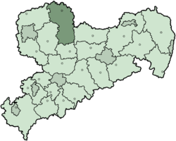
Torgau-Oschatz is a former district (Kreis) in the Free State of Saxony, Germany. It was bounded by (from the north and clockwise) the district Wittenberg in Saxony-Anhalt, the district Elbe-Elster in Brandenburg, and the districts Riesa-Großenhain, Döbeln, Muldentalkreis and Delitzsch.
History
The district was created in 1994 by merging the two previous districts Oschatz and Torgau, and 6 municipalities from the former district Eilenburg. In August 2008, as a part of the district reform in Saxony, the districts of Delitzsch and Torgau-Oschatz were merged into the new district Nordsachsen.
Geography
The main river in the district is the Elbe, which meanders through water meadows. The landscape is dominated by three heath areas, the Dahlener Heide (150 km²) in the south, the Düben Heath (110 km²) in the northwest, and partially the Annaburger Heide in the east.
Coat of arms
 |
The main symbol in the coat of arms is the lion of Meißen, as the area of the district belonged to the county of Meißen historically. The lion holds a linden branch, symbolizing both the forests and the agriculture in the district. The wavy line in the bottom is the Elbe river.
The coat of arms were granted on January 12, 1996. |
Towns and municipalities
| Towns | Verwaltungsgemeinschaften | free municipalities |
|---|---|---|
|
¹ Administrated in a |
External links
- Official website (German)
| Urban districts | |
|---|---|
| Rural districts | |
| Former urban districts | |
| Former rural districts | |
Towns and municipalities in Torgau-Oschatz | ||
|---|---|---|
Coordinates: 51°33′36″N 13°00′36″E / 51.56000°N 13.01000°E