Towanda Township, Butler County, Kansas
| Towanda Township | |
|---|---|
| Township | |
 Location in Butler County | |
| Coordinates: 37°46′55″N 096°59′21″W / 37.78194°N 96.98917°WCoordinates: 37°46′55″N 096°59′21″W / 37.78194°N 96.98917°W | |
| Country | United States |
| State | Kansas |
| County | Butler |
| Area | |
| • Total | 36 sq mi (93.25 km2) |
| • Land | 35.95 sq mi (93.12 km2) |
| • Water | 0.05 sq mi (0.13 km2) 0.14% |
| Elevation | 1,302 ft (397 m) |
| Population (2000) | |
| • Total | 2,727 |
| • Density | 75.9/sq mi (29.3/km2) |
| GNIS feature ID | 0474577 |
Towanda Township is a township in Butler County, Kansas, USA. As of the 2000 census, its population was 2,727.
History
Towanda Township was established in 1867.[1] Towanda is an Osage-language name meaning "many waters".[2]
Geography
Towanda Township covers an area of 36 square miles (93 km2) and contains one incorporated settlement, Towanda. According to the USGS, it contains one cemetery, Sutton.
The streams of Badger Creek, Spring Branch and West Branch Whitewater River run through this township.
Transportation
Towanda Township contains one airport or landing strip, Greer Miller Landing Strip.
Further reading
References
- ↑ Mooney, Vol. P. (1916). History of Butler County Kansas. Standard Publishing Company. p. 218.
- ↑ "Profile for Towanda, Kansas". ePodunk. Retrieved 5 June 2014.
External links
Municipalities and communities of Butler County, Kansas, United States | ||
|---|---|---|
| Cities | 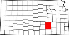 | |
| CDP | ||
| Unincorporated communities | ||
| Ghost towns | ||
| Townships | ||
| Footnotes | ‡This populated place also has portions in an adjacent county or counties | |
This article is issued from Wikipedia - version of the 11/1/2016. The text is available under the Creative Commons Attribution/Share Alike but additional terms may apply for the media files.