Townsend (CDP), Wisconsin
| Townsend, Wisconsin | |
|---|---|
| Unincorporated community | |
 Townsend, Wisconsin | |
| Coordinates: 45°19′41″N 88°35′22″W / 45.32806°N 88.58944°WCoordinates: 45°19′41″N 88°35′22″W / 45.32806°N 88.58944°W | |
| Country | United States |
| State | Wisconsin |
| County | Oconto |
| Area | |
| • Total | 0.404 sq mi (1.05 km2) |
| • Land | 0.404 sq mi (1.05 km2) |
| • Water | 0 sq mi (0 km2) |
| Elevation | 1,355 ft (413 m) |
| Population (2010) | |
| • Total | 146 |
| • Density | 360/sq mi (140/km2) |
| Time zone | Central (CST) (UTC-6) |
| • Summer (DST) | CDT (UTC-5) |
| ZIP code | 54175 |
| Area code(s) | 715 & 534 |
| GNIS feature ID | 1580636[1] |
Townsend is an unincorporated census-designated place located in the town of Townsend, Oconto County, Wisconsin, United States. Townsend is located on Wisconsin Highway 32 22.5 miles (36.2 km) southeast of Crandon. Townsend has a post office with ZIP code 54175.[2] As of the 2010 census, its population is 146.[3]
References
Municipalities and communities of Oconto County, Wisconsin, United States | ||
|---|---|---|
| Cities | 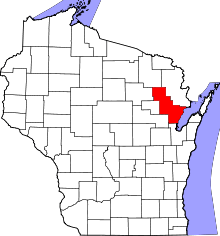 | |
| Villages | ||
| Towns | ||
| CDPs | ||
| Unincorporated communities | ||
| Indian reservation | ||
| Ghost town |
| |
| Footnotes | ‡This populated place also has portions in an adjacent county or counties | |
This article is issued from Wikipedia - version of the 9/4/2016. The text is available under the Creative Commons Attribution/Share Alike but additional terms may apply for the media files.