Toyei, Arizona
| Toyei, Arizona | |
|---|---|
| Census-designated place | |
 Toyei | |
| Coordinates: 35°42′09″N 109°56′17″W / 35.70250°N 109.93806°WCoordinates: 35°42′09″N 109°56′17″W / 35.70250°N 109.93806°W | |
| Country | United States |
| State | Arizona |
| County | Apache |
| Area | |
| • Total | 0.3 sq mi (0.8 km2) |
| • Land | 0.3 sq mi (0.8 km2) |
| • Water | 0 sq mi (0 km2) |
| Elevation | 6,523 ft (1,988 m) |
| Population (2010) | |
| • Total | 13 |
| • Density | 40/sq mi (15.5/km2) |
| Time zone | MST (UTC-7) |
| FIPS code | 04-75310 |
| GNIS feature ID | 0025273 |
Toyei is a census-designated place (CDP) in Apache County, Arizona, United States. The population was 13 at the 2010 census.[1]
Geography
Toyei is located at 35°42′09″N 109°56′17″W / 35.70250°N 109.93806°W (35.70251, −109.93817).
According to the United States Census Bureau, the CDP has a total area of 0.31 square miles (0.8 km2), all of it land.[1]
References
- 1 2 "Geographic Identifiers: 2010 Demographic Profile Data (G001): Toyei CDP, Arizona". U.S. Census Bureau, American Factfinder. Retrieved April 30, 2013.
Municipalities and communities of Apache County, Arizona, United States | ||
|---|---|---|
| City | 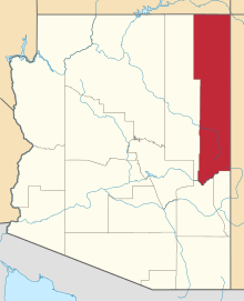 | |
| Towns | ||
| CDPs |
| |
| Populated places |
| |
| Indian reservations | ||
| Footnotes | ‡This populated place also has portions in an adjacent county or counties | |
This article is issued from Wikipedia - version of the 6/10/2014. The text is available under the Creative Commons Attribution/Share Alike but additional terms may apply for the media files.