Trams in Jena
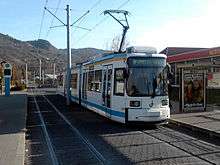 A GT6M-ZR tram at the Burgau stop, 2008. | |||
| Operation | |||
|---|---|---|---|
| Locale | Jena, Thuringia, Germany | ||
| Open | 1901 | ||
| Status | Operational | ||
| Lines |
| ||
| Operator(s) | Jenaer Nahverkehrsgesellschaft | ||
| Infrastructure | |||
| Track gauge | 1,000 mm (3 ft 3 3⁄8 in) metre gauge | ||
| Propulsion system(s) | Electricity | ||
| |||
| Website | Jenaer Nahverkehrsgesellschaft mbH (German) | ||

The Jena tramway network (German: Straßenbahnnetz Jena) is a network of tramways forming part of the public transport system in Jena, a city in the federal state of Thuringia, Germany.
Opened in 1901, the network is currently operated by Jenaer Nahverkehrsgesellschaft; it has five lines in operation during the day, and three lines operating in the evening and/or overnight.
Lines
On 17 December 2009, a new network of lines was introduced to coincide with the opening of the new Göschwitz–Burgau line.
Daytime network
| Line | Route |
|---|---|
| 1 | Zwätzen–Stadtzentrum–Burgau–Bahnhof Göschwitz–Lobeda-West |
| 2 | Jena-Ost–Stadtzentrum–Winzerla |
| 3 | Jena-Ost–Stadtzentrum–Burgau–Bahnhof Göschwitz–Lobeda-West–Lobeda-Ost |
| 4 | Zwätzen–Stadtzentrum–Alt-Lobeda–Lobeda-West |
| 5 | Ernst-Abbe-Platz–Stadtzentrum–Lobeda-Ost |
Lines 1 and 4 operate in fliegende Wechsel (flying exchange): i.e., at Lobeda-West all trams arriving on one of these lines departs on the other.
Late and night network
| Line | Route |
|---|---|
| 33 | Jena-Ost–Stadtzentrum–Ernst-Abbe-Platz |
| 34 | Zwätzen–Stadtzentrum–Winzerla–Alt-Lobeda–Lobeda-West–Lobeda-Ost |
| 35 | Ernst-Abbe-Platz–Burgau–Bf. Göschwitz–Lobeda-Ost |
See also
References
- Bauer, Gerhard; Kuschinski, Norbert (1994). Die Straßenbahnen in Ostdeutschland [The Tramways in East Germany]. Band 2: Sachsen-Anhalt, Thüringen [Volume 2: Saxony-Anhalt, Thuringia]. Aachen, Germany: Schweers + Wall. ISBN 392167980X. (German)
- Schwandl, Robert (2012). Schwandl's Tram Atlas Deutschland (in German and English) (3rd ed.). Berlin: Robert Schwandl Verlag. ISBN 9783936573336.
External links
![]() Media related to Trams in Jena at Wikimedia Commons
Media related to Trams in Jena at Wikimedia Commons
- Jena database / photo gallery and Jena tram list at Urban Electric Transit – in various languages, including English.
- Jena database / photo gallery at Phototrans – in various languages, including English.
| Baden-Württemberg |  | |
|---|---|---|
| Bavaria | ||
| Berlin | ||
| Brandenburg |
| |
| Bremen | ||
| Hesse | ||
| Lower Saxony | ||
| Mecklenburg-Vorpommern | ||
| North Rhine-Westphalia | ||
| Rhineland-Palatinate | ||
| Saarland | ||
| Saxony | ||
| Saxony-Anhalt | ||
| Thuringia | ||
| ||
Urban public transport networks and systems in Germany | ||
|---|---|---|
| S-Bahn |    | |
| U-Bahn | ||
| Stadtbahn | ||
| Trams |
| |
| Trolleybuses | ||
| Suspension monorails | ||
| Other | ||
| ||
Coordinates: 50°55′N 11°35′E / 50.917°N 11.583°E
This article is issued from Wikipedia - version of the 11/15/2016. The text is available under the Creative Commons Attribution/Share Alike but additional terms may apply for the media files.