Trams in Rostock
 | |||||||||||||||||||||
| Operation | |||||||||||||||||||||
|---|---|---|---|---|---|---|---|---|---|---|---|---|---|---|---|---|---|---|---|---|---|
| Locale | Rostock, Mecklenburg-Vorpommern, Germany | ||||||||||||||||||||
| |||||||||||||||||||||
| |||||||||||||||||||||

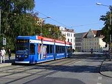
The Rostock tramway network (German: Straßenbahnnetz Rostock) is a network of tramways forming the centrepiece of the public transport system in Rostock, the largest city in the federal state of Mecklenburg-Vorpommern, Germany.
Opened in 1881 as a horsecar system, the network was converted to electrical operation in 1904. It is currently operated by Rostocker Straßenbahn AG (RSAG).
Lines
As of 2013, the network had six lines, as follows:
| Since 2009 | ||
|---|---|---|
| Line | Route | Notes |
| 1 | (Lichtenhagen, Mecklenburger Allee –) Lütten Klein, Rügener Straße – Evershagen – Marienehe – Reutershagen – Doberaner Platz – Steintor – Dierkower Kreuz – Hafenallee | extended to Lichtenhagen in the evenings and on weekends |
| 2 | Südblick – Goetheplatz – Lange Straße – Steintor – Dierkower Kreuz – Kurt-Schumacher-Ring | daily during the day |
| 3 | Neuer Friedhof – Doberaner Platz – Goetheplatz – Hauptbahnhof – Steintor – Dierkower Kreuz – HP Dierkow | during the evenings on workdays; all day on weekends |
| 4 | Lütten Klein, Rügener Straße – Evershagen – Marienehe – Reutershagen – Doberaner Platz – Goetheplatz – Hauptbahnhof – Steintor – Dierkower Kreuz – HP Dierkow | during the day on workdays |
| 5 | Lichtenhagen, Mecklenburger Allee – Lütten Klein, Rügener Straße – Evershagen – Marienehe – Reutershagen – Doberaner Platz – Lange Straße – Steintor – Hauptbahnhof – Südblick | |
| 6 | Neuer Friedhof – Doberaner Platz – Lange Straße – Steintor – Hauptbahnhof – Mensa | daily during the day |
See also
References
- Bauer, Gerhard; Kuschinski, Norbert (1995). Die Straßenbahnen in Ostdeutschland [The Tramways in East Germany]. Band 3: Berlin, Brandenburg, Mecklenburg-Vorpommern [Volume 3: Berlin, Brandenburg, Mecklenburg-Vorpommern]. Aachen, Germany: Schweers + Wall. ISBN 3921679818. (German)
- Grabowski, Rüdiger; Enenkel, Norbert (2006). Straßenbahnen und Busse in Rostock [Trams and Buses in Rostock] (in German). Nordhorn: Verlag Kenning. ISBN 3-933613-81-7.
- Schwandl, Robert (2012). Schwandl's Tram Atlas Deutschland (in German and English) (3rd ed.). Berlin: Robert Schwandl Verlag. ISBN 9783936573336.
- Rostocker Strassenbahn AG: Menschen, Technik, Episoden [Rostocker Strassenbahn AG: People, Technology, Episodes] (in German). Rostock: Redieck & Schade. 2001. ISBN 3-933613-81-7.
External links
![]() Media related to Trams in Rostock at Wikimedia Commons
Media related to Trams in Rostock at Wikimedia Commons
- Rostock database / photo gallery and Rostock tram list at Urban Electric Transit – in various languages, including English.
- Rostock database / photo gallery at Phototrans – in various languages, including English.
| Baden-Württemberg |  | |
|---|---|---|
| Bavaria | ||
| Berlin | ||
| Brandenburg |
| |
| Bremen | ||
| Hesse | ||
| Lower Saxony | ||
| Mecklenburg-Vorpommern | ||
| North Rhine-Westphalia | ||
| Rhineland-Palatinate | ||
| Saarland | ||
| Saxony | ||
| Saxony-Anhalt | ||
| Thuringia | ||
| ||
Urban public transport networks and systems in Germany | ||
|---|---|---|
| S-Bahn |    | |
| U-Bahn | ||
| Stadtbahn | ||
| Trams |
| |
| Trolleybuses | ||
| Suspension monorails | ||
| Other | ||
| ||
Coordinates: 54°5′9″N 12°8′28″E / 54.08583°N 12.14111°E
This article is issued from Wikipedia - version of the 11/15/2016. The text is available under the Creative Commons Attribution/Share Alike but additional terms may apply for the media files.