Trollhetta
| Trollhøtta | |
|---|---|
| Trollhetta | |
 | |
| Highest point | |
| Elevation | 1,616 m (5,302 ft) |
| Prominence | 884 m (2,900 ft) |
| Isolation | 10.29 kilometres (6.39 mi) |
| Coordinates | 62°51′07″N 09°19′27″E / 62.85194°N 9.32417°ECoordinates: 62°51′07″N 09°19′27″E / 62.85194°N 9.32417°E |
| Geography | |
 Trollhetta Location in Møre og Romsdal | |
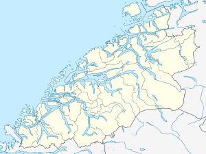
| Location | Surnadal/Rindal, Møre og Romsdal, Norway |
| Parent range | Trollheimen |
| Topo map | 1420 I Snota |
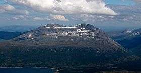
Trollhøtta or Trollhetta is a mountain in the border of the municipalities of Surnadal and Rindal in Møre og Romsdal county, Norway. It is part of the Trollheimen mountain range, just east of the lake Gråsjøen and the mountains Snota and Neådalssnota. To the south, across the valley Svartådalen, you see the mountains Geithetta and Svarthetta.
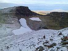
The mountain has three peaks: the eastern peak is 1,522 metres (4,993 ft) tall, the north one is 1,596 metres (5,236 ft) and the south one is 1,616 metres (5,302 ft). You can access all three peaks during summer, but a sharp and steep ridge between the eastern and northern peak is problematic in the winter for access from the east. The Norwegian Mountain Touring Association has a cabin, Trollheimshytta, near the foot of the northern peak. In the east, there is the cabin Jøldalshytta.[1]
References
- ↑ Store norske leksikon. "Trollhetta" (in Norwegian). Retrieved 2010-12-07.