Surnadal
| Surnadal kommune | |||
|---|---|---|---|
| Municipality | |||
.jpg) | |||
| |||
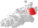 Surnadal within Møre og Romsdal | |||
| Coordinates: 62°56′51″N 08°46′12″E / 62.94750°N 8.77000°ECoordinates: 62°56′51″N 08°46′12″E / 62.94750°N 8.77000°E | |||
| Country | Norway | ||
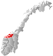
| County | Møre og Romsdal | ||
| District | Nordmøre | ||
| Administrative centre | Skei | ||
| Government | |||
| • Mayor (2007) | Mons Otnes (Ap) | ||
| Area | |||
| • Total | 1,365.41 km2 (527.19 sq mi) | ||
| • Land | 1,314.22 km2 (507.42 sq mi) | ||
| • Water | 51.19 km2 (19.76 sq mi) | ||
| Area rank | 64 in Norway | ||
| Population (2013) | |||
| • Total | 5,927 | ||
| • Rank | 161 in Norway | ||
| • Density | 4.5/km2 (12/sq mi) | ||
| • Change (10 years) | -4.5 % | ||
| Demonym(s) | Surndaling[1] | ||
| Time zone | CET (UTC+1) | ||
| • Summer (DST) | CEST (UTC+2) | ||
| ISO 3166 code | NO-1566 | ||
| Official language form | Nynorsk | ||
| Website |
www | ||
|
| |||

![]() Surnadal is a municipality in Møre og Romsdal county, Norway. It is part of the Nordmøre region. The administrative centre is the village of Skei. Other villages in Surnadal include Glærem, Mo, Stangvik, Surnadalsøra, Sylte, Todalsøra, and Åsskard.
Surnadal is a municipality in Møre og Romsdal county, Norway. It is part of the Nordmøre region. The administrative centre is the village of Skei. Other villages in Surnadal include Glærem, Mo, Stangvik, Surnadalsøra, Sylte, Todalsøra, and Åsskard.
A mild climate and rich soil make Surnadal well suited for agriculture. The local economy is based on agriculture, forestry and industrial production, in addition to services.[2]
General information
The parish of Surnadal was established as a municipality on 1 January 1838 (see formannskapsdistrikt). In 1858, the eastern district (population: 2,684) was separated from Surnadal to form the new Rindal Municipality. This left Surnadal with 3,105 residents. On 1 January 1877, part of Stangvik (population: 50) was transferred to Surnadal. In 1879, part of Surnadal (population: 83) was transferred to Stangvik. On 1 January 1886, the Møklegjerdet farm (population: 29), just west of Glærem, was transferred from Stangvik to Surnadal. On 1 January 1897, the Sjøflot farm (population: 27) was also transferred from Stangvik to Surnadal. On 1 January 1965, the whole municipality of Åsskard and most of the municipality of Stangvik were merged into Surnadal. The newly enlarged municipality had a population of 5,934.[3]
Name
The Old Norse form of the name was Súrnardalr. The first element is the genitive case of the river name Surna and the last element is dalr which means "valley" or "dale". The meaning of the river name is unknown. Before 1918, the name was written Surendalen.[4]
Coat-of-arms
The coat-of-arms is from modern times (1989). It shows two silver wavy lines on a green background. The silver lines represent the many rivers in the municipality, the most notable one being the Surna.[2]
Churches
The Church of Norway has five parishes (sokn) within the municipality of Surnadal. It is part of the Indre Nordmøre deanery in the Diocese of Møre.
| Parish (Sokn) | Church Name | Location of the Church | Year Built |
|---|---|---|---|
| Mo | Mo Church | Mo | 1728 |
| Stangvik | Stangvik Church | Stangvik | 1896 |
| Todalen | Todalen Church | Todalsøra | 1861 |
| Øye og Ranes | Ranes Church | Ranes | 1869 |
| Øye Church | Skei | 1871 | |
| Åsskard | Åsskard Church | Åsskard | 1876 |
Geography
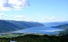
The municipality is made up by the main valley, Surnadalen through which the river Surna runs. There are also many smaller side valleys including Stor-Bæverdalen, Settemsdalen, Øvstbødalen, Todalen, and Vinddøldalen. The municipality is bordered by the Trollheimen mountain range and Sunndal Municipality to the south, the neighboring Rindal Municipality to the east, Halsa Municipality to the north, and several fjords to the west: Trongfjorden, Stangvikfjorden, and Todalsfjorden. There are three main fjords that cut into the municipality: Åsskardfjorden, Hamnesfjorden, and Surnadalsfjorden.
The landscape is a combination of forests, fjords, and mountains. The highest mountain peak is Snota at 1,668 metres (5,472 ft) above sea level. Other mountains include Vassnebba, Indre Sula and Ytre Sula, Neådalssnota, and Trollhetta. The river Surna runs through the valley from the east to the west, and forms a large delta where it enters the fjord near Surnadalsøra and Skei. This river is rich on salmon, which attract tourists from the rest of the country and abroad. The lakes Foldsjøen and Gråsjøen lie along the border with Rindal Municipality in the east.
Transportation
Transportation services include ferries to the southwest and the northwest, which lead to the coastal areas of Møre og Romsdal, and a highway to the city of Trondheim to the east.
Notable residents
- Sverre Årnes, writer and translator
- Hans Hyldbakk, a nationally recognized author of poetry and local history. Surnadal is noted for strong traditions in the field of poetry and folklore.
- Rune Gjeldnes, explorer
References
- ↑ "Navn på steder og personer: Innbyggjarnamn" (in Norwegian). Språkrådet. Retrieved 2015-12-01.
- 1 2 Store norske leksikon. "Surnadal" (in Norwegian). Retrieved 2013-04-20.
- ↑ Jukvam, Dag (1999). "Historisk oversikt over endringer i kommune- og fylkesinndelingen" (PDF) (in Norwegian). Statistisk sentralbyrå.
- ↑ Rygh, Oluf (1908). Norske gaardnavne: Romsdals amt (in Norwegian) (13 ed.). Kristiania, Norge: W. C. Fabritius & sønners bogtrikkeri. p. 410.
External links
 Media related to Surnadal at Wikimedia Commons
 Møre og Romsdal travel guide from Wikivoyage
- Municipal fact sheet from Statistics Norway