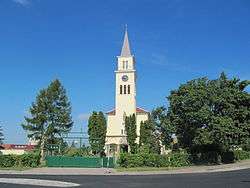
Tvrdonice
| Tvrdonice | |||
|---|---|---|---|
| Municipality | |||
 | |||
| |||
 Tvrdonice | |||
| Coordinates: 48°45′39″N 16°59′16″E / 48.76083°N 16.98778°ECoordinates: 48°45′39″N 16°59′16″E / 48.76083°N 16.98778°E | |||
| Country |
| ||
| Region | South Moravian | ||
| District | Břeclav | ||
| Area | |||
| • Total | 21.15 km2 (8.17 sq mi) | ||
| Population (1.1.2012) | |||
| • Total | 2,133 | ||
| • Density | 100/km2 (260/sq mi) | ||
| Postal code | 691 53 | ||
| Website | http://www.podluzi.cz | ||
Tvrdonice is a village and municipality (obec) in Břeclav District in the South Moravian Region of the Czech Republic.
The municipality covers an area of 21.15 square kilometres (8.17 sq mi), and has a population of 2,046 (as at 28 August 2006).
Tvrdonice lies approximately 8 kilometres (5 mi) east of Břeclav, 56 km (35 mi) south-east of Brno, and 238 km (148 mi) south-east of Prague.
References
| Wikimedia Commons has media related to Tvrdonice. |
This article is issued from Wikipedia - version of the 10/8/2016. The text is available under the Creative Commons Attribution/Share Alike but additional terms may apply for the media files.