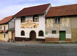
Kobylí
| Kobylí | |||
|---|---|---|---|
| Municipality | |||
 | |||
| |||
 Kobylí | |||
| Coordinates: 48°55′58″N 16°53′42″E / 48.93278°N 16.89500°ECoordinates: 48°55′58″N 16°53′42″E / 48.93278°N 16.89500°E | |||
| Country |
| ||
| Region | South Moravian | ||
| District | Břeclav | ||
| Area | |||
| • Total | 21.14 km2 (8.16 sq mi) | ||
| Elevation | 205 m (673 ft) | ||
| Population (2007) | |||
| • Total | 2,082 | ||
| • Density | 98/km2 (260/sq mi) | ||
| Postal code | 691 10 | ||
| Website | http://www.kobyli.cz | ||
Kobylí is a village and municipality (obec) in Břeclav District in the South Moravian Region of the Czech Republic.
The municipality covers an area of 21.14 square kilometres (8.16 sq mi), and has a population of 2,082 (as at 31 December 2007).
Kobylí lies approximately 20 kilometres (12 mi) north of Břeclav, 36 km (22 mi) south-east of Brno, and 220 km (137 mi) south-east of Prague.
References
| Wikimedia Commons has media related to Kobylí. |
This article is issued from Wikipedia - version of the 4/7/2016. The text is available under the Creative Commons Attribution/Share Alike but additional terms may apply for the media files.