Twelve Bens
| Twelve Bens | |
|---|---|
| Irish: Na Beanna Beola | |
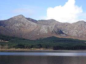 Bencorr from across Lough Inagh | |
| Highest point | |
| Peak | Benbaun |
| Elevation | 729 m (2,392 ft) |
| Geography | |
| Country | Republic of Ireland |
| Provinces of Ireland | Connacht |
The Twelve Bens, or Twelve Pins (Irish: Na Beanna Beola), is a mountain range of sharp-peaked quartzite ranges located northeast of Roundstone in Connemara in the west of Ireland. Dedicated fell runners attempt to hike all twelve peaks in a single day. Topographically, this range is partnered with the Maumturks range on the other side of the lonely Glen Inagh (and the route of Western Way long distance path). Frequent rainfall and steep-sided mountains produce an abundance of small trickles and streams which descend into wide-bottomed valleys below the Twelve Pins to join larger streams with riffles and pools. The highest point in the Twelve Bens is Benbaun at 729 metres (2,392 ft). They provide excellent walking and climbing opportunities for outdoor enthusiasts.
Highest points
The following table lists the 12 highest major mountain peaks of the Twelve Bens Mountains, all with a topographic elevation of at least 516 metres (1,693 ft). There are a number of mountains higher than Benglenisky, but do not have sufficient prominence to be included in this list.
| Rank | Mountain peak | Elevation | English Name |
|---|---|---|---|
| 1 | Binn Bhán | 729 m (2,392 ft) | Benbaun |
| 2 | Binn Chorr | 711 m (2,333 ft) | Bencorr |
| 3 | Binn Dubh | 696 m (2,283 ft) | Bencollaghduff |
| 4 | Binn Bhraoin | 691 m (2,267 ft) | Benbreen |
| 5 | Binn Doire Chláir | 677 m (2,221 ft) | Derryclare |
| 6 | Binn Gabhar | 664 m (2,178 ft) | Bengower |
| 7 | Meacanach | 654 m (2,146 ft) | Muckanaght |
| 8 | Binn Fraoigh | 638 m (2,093 ft) | Benfree |
| 9 | An Chailleach | 632 m (2,073 ft) | Bencullagh |
| 10 | Binn Breac | 582 m (1,909 ft) | Benbrack |
| 11 | Ben Letterry | 577 m (1,893 ft) | Ben Letterry |
| 12 | Binn Glean Uisce | 516 m (1,693 ft) | Benglenisky |

Further reading
- "The Mountains of Connemara : A Hill Walker's Guide" (ISBN 0-9504002-4-6) includes a more useful 1:50000 map than the OS maps 37, 38, 44.
Other projects
![]() Media related to Twelve Bens at Wikimedia Commons
Media related to Twelve Bens at Wikimedia Commons
External links
Coordinates: 53°30′N 9°49′W / 53.50°N 9.81°W
Mountains and hills of Connacht | ||
|---|---|---|
| Achill Island | 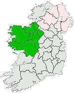 | |
| Dartry Mountains | ||
| Maumturks | ||
| Nephin Range | ||
| Ox Mountains | ||
| Partry Mountains | ||
| Sheeffry Range | ||
| Twelve Bens | ||
| Others | ||