Unionville Historic District
|
Unionville Historic District | |
|
Unionville Historic District, May 2010 | |
  | |
| Location | U.S. Route 220 and Pennsylvania Route 504, Unionville, Pennsylvania |
|---|---|
| Coordinates | 40°54′22″N 77°52′34″W / 40.90611°N 77.87611°WCoordinates: 40°54′22″N 77°52′34″W / 40.90611°N 77.87611°W |
| Area | 120 acres (49 ha) |
| Built | 1848 |
| Architectural style | Mid 19th Century Revival, Italianate, Georgian |
| NRHP Reference # | 79002194[1] |
| Added to NRHP | May 30, 1979 |
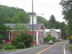
Unionville Historic District is a national historic district located at Unionville, Centre County, Pennsylvania. The district includes 173 contributing buildings and 3 contributing sites in the central business district and surrounding residential area of Unionville. The buildings are primarily residential and date as early as 1848 and include a number of plan "I"-pan houses and other vernacular or folk house types. Notable non-residential buildings include the Moses-Taylor Tavern, Peters Temperance House, Union Church, Methodist Church (c. 1860), Griest Store, and Union Grange Hall.[2]
It was added to the National Register of Historic Places in 1979.[1]
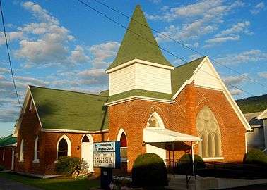 Fleming Free Methodist Church
References
- 1 2 National Park Service (2009-03-13). "National Register Information System". National Register of Historic Places. National Park Service.
- ↑ "National Historic Landmarks & National Register of Historic Places in Pennsylvania" (Searchable database). CRGIS: Cultural Resources Geographic Information System. Note: This includes William M. Laughlin and Nancy Reade (n.d.). "National Register of Historic Places Inventory Nomination Form: Unionville Historic District" (PDF). Retrieved 2011-11-05.
| Topics |   | |
|---|---|---|
| Lists by county |
| |
| Lists by city | ||
| Other lists | ||
| ||
This article is issued from Wikipedia - version of the 11/29/2016. The text is available under the Creative Commons Attribution/Share Alike but additional terms may apply for the media files.