Vanndale, Arkansas
| Vanndale, Arkansas | |
|---|---|
| Unincorporated community | |
 Vanndale, Arkansas Vanndale's position in Arkansas. | |
| Coordinates: 35°18′48″N 90°46′26″W / 35.31333°N 90.77389°WCoordinates: 35°18′48″N 90°46′26″W / 35.31333°N 90.77389°W | |
| Country |
|
| State |
|
| County | Cross |
| Township | Searcy |
| Elevation | 84 m (276 ft) |
| Time zone | Central (CST) (UTC-6) |
| • Summer (DST) | CDT (UTC-5) |
| ZIP code | 72387 |
| Area code(s) | 870 |
| GNIS feature ID | 78652 |
| U.S. Geological Survey Geographic Names Information System: Vanndale, Arkansas | |
Vanndale, Arkansas (formerly Oak Grove) is an unincorporated community in Searcy Township, Cross County, Arkansas, United States.[1] Vanndale was the county seat of Cross County from 1886 until 1903, when it was moved to the booming railroad town of Wynne. The community was named for John W. Vann, postmaster. Vanndale was formerly on Highway 1, but has now been bypassed and is on Highway 1B.
Education
Public education for elementary and secondary students is provided by the Cross County School District, which leads to graduation from Cross County High School. The district's mascot and athletic emblem is the Thunderbird.
References
- ↑ "Feature Detail Report for: Vanndale, Arkansas." USGS. U.S. Geological Survey Geographic Names Information System: Vanndale, Arkansas Retrieved January 25, 2011.
Municipalities and communities of Cross County, Arkansas, United States | ||
|---|---|---|
| Cities | 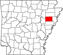 | |
| Unincorporated communities | ||
This article is issued from Wikipedia - version of the 11/17/2014. The text is available under the Creative Commons Attribution/Share Alike but additional terms may apply for the media files.