Vauxcéré
| Vauxcéré | |
|---|---|
 Vauxcéré | |
|
Location within Hauts-de-France region  Vauxcéré | |
| Coordinates: 49°20′32″N 3°38′11″E / 49.3422°N 3.6364°ECoordinates: 49°20′32″N 3°38′11″E / 49.3422°N 3.6364°E | |
| Country | France |
| Region | Hauts-de-France |
| Department | Aisne |
| Arrondissement | Soissons |
| Canton | Braine |
| Intercommunality | Val de l'Aisne |
| Government | |
| • Mayor (2008–2014) | Yves Menu |
| Area1 | 5.8 km2 (2.2 sq mi) |
| Population (2008)2 | 111 |
| • Density | 19/km2 (50/sq mi) |
| Time zone | CET (UTC+1) |
| • Summer (DST) | CEST (UTC+2) |
| INSEE/Postal code | 02771 / 02160 |
| Elevation |
65–182 m (213–597 ft) (avg. 150 m or 490 ft) |
|
1 French Land Register data, which excludes lakes, ponds, glaciers > 1 km² (0.386 sq mi or 247 acres) and river estuaries. 2 Population without double counting: residents of multiple communes (e.g., students and military personnel) only counted once. | |
Vauxcéré is a former commune in the department of Aisne in northern France. On 1 January 2016, it was merged into the new commune Les Septvallons.[1]
Population
| Historical population | ||
|---|---|---|
| Year | Pop. | ±% |
| 1962 | 112 | — |
| 1968 | 104 | −7.1% |
| 1975 | 82 | −21.2% |
| 1982 | 90 | +9.8% |
| 1990 | 83 | −7.8% |
| 1999 | 96 | +15.7% |
| 2008 | 111 | +15.6% |
See also
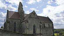
Church.
References
- ↑ Arrêté préfectoral 9 November 2015 (French)
| Wikimedia Commons has media related to Vauxcéré. |
I
This article is issued from Wikipedia - version of the 11/21/2016. The text is available under the Creative Commons Attribution/Share Alike but additional terms may apply for the media files.