Virginia Gardens, Florida
| Virginia Gardens, Florida Village of Virginia Gardens | ||
|---|---|---|
| Village | ||
| ||
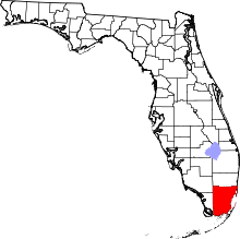
 Location in Miami-Dade County and the state of Florida | ||
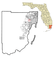
 U.S. Census Bureau map showing village boundaries | ||
| Coordinates: 25°48′33.03″N 80°17′48.11″W / 25.8091750°N 80.2966972°WCoordinates: 25°48′33.03″N 80°17′48.11″W / 25.8091750°N 80.2966972°W | ||
| Country |
| |
| State |
| |
| County |
| |
| Incorporated | July 10, 1947 | |
| Government | ||
| • Type | Mayor-Council | |
| • Mayor | Spencer Deno IV | |
| • Councilmembers | Debra Conover, Jorge Arce, Richard Block, Steven K. Petterson, and Elizabeth Taylor-Martinez | |
| • Village Manager | Mayor Spencer Deno IV | |
| • Village Clerk | Maritza Fernandez | |
| Area | ||
| • Village | 0.3 sq mi (0.8 km2) | |
| • Land | 0.3 sq mi (0.8 km2) | |
| • Water | 0 sq mi (0 km2) 0% | |
| Elevation | 3 ft (1 m) | |
| Population (2010) | ||
| • Village | 2,375 | |
| • Density | 8,062.3/sq mi (3,112.9/km2) | |
| • Metro | 5,422,200 | |
| Time zone | EST (UTC-5) | |
| • Summer (DST) | EDT (UTC-4) | |
| Zip Code | 33166 | |
| Area code(s) | 305, 786 | |
| FIPS code | 12-74575[1] | |
| GNIS feature ID | 0292782[2] | |
| Website | http://www.virginiagardens-fl.gov/ | |

Virginia Gardens is a village in Miami-Dade County, Florida, United States. According to the U.S. Census Bureau, the village had a population of 2,375 in 2010.
History
The tiny enclave of Virginia Gardens was born out of the love of horses. In 1947, Miami Springs (of which it was then a part) passed an ordinance outlawing horses from the city limits. In response, about 50 citizens decided to form their own city next door.[3]
Virginia Gardens got its name because many of the founding residents were wealthy transplants who aptly named the village after their home state. At the time of incorporation, many of the residents owned large estates, some up to 5 acres (20,000 m2), where they could ride and enjoy their horses. Only a single 1-acre (4,000 m2) residential property remains within the village limits today; the bulk of residential property now consists of 0.2-acre (810 m2) lots typical of suburban developments.[3]
Geography
Virginia Gardens is located at 25°48′33″N 80°17′48″W / 25.80917°N 80.29667°W (25.809175, -80.296697).[4]
According to the United States Census Bureau, the village has a total area of 0.3 square miles (0.78 km2), all land.
Demographics
| Historical population | |||
|---|---|---|---|
| Census | Pop. | %± | |
| 1950 | 235 | — | |
| 1960 | 2,159 | 818.7% | |
| 1970 | 2,524 | 16.9% | |
| 1980 | 2,098 | −16.9% | |
| 1990 | 2,212 | 5.4% | |
| 2000 | 2,348 | 6.1% | |
| 2010 | 2,375 | 1.1% | |
| Est. 2015 | 2,487 | [5] | 4.7% |
| Virginia Gardens Demographics | |||
|---|---|---|---|
| 2010 Census | Virginia Gardens | Miami-Dade County | Florida |
| Total population | 2,375 | 2,496,435 | 18,801,310 |
| Population, percent change, 2000 to 2010 | +1.1% | +10.8% | +17.6% |
| Population density | 8,062.3/sq mi | 1,315.5/sq mi | 350.6/sq mi |
| White or Caucasian (including White Hispanic) | 90.7% | 73.8% | 75.0% |
| (Non-Hispanic White or Caucasian) | 19.3% | 15.4% | 57.9% |
| Black or African-American | 2.7% | 18.9% | 16.0% |
| Hispanic or Latino (of any race) | 77.3% | 65.0% | 22.5% |
| Asian | 1.7% | 1.5% | 2.4% |
| Native American or Native Alaskan | 0.0% | 0.2% | 0.4% |
| Pacific Islander or Native Hawaiian | 0.0% | 0.0% | 0.1% |
| Two or more races (Multiracial) | 2.1% | 2.4% | 2.5% |
| Some Other Race | 2.8% | 3.2% | 3.6% |
As of 2010, there were 949 households of which 5.3% were vacant. In 2000, 31.7% had children under the age of 18 living with them, 47.3% were married couples living together, 14.9% had a female householder with no husband present, and 33.0% were non-families. 27.1% of all households were made up of individuals and 7.9% had someone living alone who was 65 years of age or older. The average household size was 2.63 and the average family size was 3.22.
In 2000, age distribution was 23.0% under the age of 18, 7.6% from 18 to 24, 31.9% from 25 to 44, 23.9% from 45 to 64, and 13.5% who were 65 years of age or older. The median age was 38 years. For every 100 females there were 97.5 males. For every 100 females age 18 and over, there were 93.1 males.
In 2000, the median household income $40,197, and the median family income was $44,800. Males had a median income of $31,302 versus $26,274 for females. The per capita income for the village was $21,139. About 9.5% of families and 11.3% of the population were below the poverty line, including 16.3% of those under age 18 and 6.6% of those age 65 or over.
In 2000, speakers of Spanish as a first language made up 71.66%, and English as a mother tongue accounted for 28.34% of the population.[7]
As of 2000, Virginia Gardens had the nineteenth-highest percentage of Cuban residents in the US, with 26.11% of the populace.[8] It had the tenth-highest percentage of Colombian residents in the US, at 7.16%,[9] and the seventh-highest percentage of Peruvian residents in the US, at 3.24% of the its population.[10] It also had the fifteenth-most Nicaraguans in the US, at 2.51%,[11] while it had the sixtieth-highest percentage of Dominicans, at 2.39% (tied with North Miami Beach.)[12] Virginia Gardens' Venezuelan community had the eighth-highest percentage of residents, which was at a 1.58% populace,[13] while the Guatemalan community had the ninety-eighth-highest percentage of residents, which was at 1.15% (tied with Bokeelia, FL.)[14] It is also home to the forty-sixth-highest percentage of Ecuadorian residents in the US, at 1.32% of the population,[15] as well as being home to the forty-second-highest percentage of Honduran, at 1.11% (tied with Atlantic City, New Jersey.)[16]
Education
Virginia Gardens is a part of Miami-Dade County Public Schools.
Public High School
- Miami Springs High School serves Virginia Gardens.
External links
- Village of Virginia Gardens official website
References
- ↑ "American FactFinder". United States Census Bureau. Retrieved 2008-01-31.
- ↑ "US Board on Geographic Names". United States Geological Survey. 2007-10-25. Retrieved 2008-01-31.
- 1 2 "Our Village History". virginiagardens-fl.gov. Retrieved 2015-01-21.
- ↑ "US Gazetteer files: 2010, 2000, and 1990". United States Census Bureau. 2011-02-12. Retrieved 2011-04-23.
- ↑ "Annual Estimates of the Resident Population for Incorporated Places: April 1, 2010 to July 1, 2015". Retrieved July 2, 2016.
- ↑ "Census of Population and Housing". Census.gov. Retrieved June 4, 2015.
- ↑ "MLA Data Center Results of Virginia Gardens, FL". Modern Language Association. Retrieved 2007-10-31.
- ↑ "Ancestry Map of Cuban Communities". Epodunk.com. Retrieved 2007-10-31.
- ↑ "Ancestry Map of Colombian Communities". Epodunk.com. Retrieved 2007-10-31.
- ↑ "Ancestry Map of Peruvian Communities". Epodunk.com. Retrieved 2007-10-31.
- ↑ "Ancestry Map of Nicaraguan Communities". Epodunk.com. Retrieved 2007-10-31.
- ↑ "Ancestry Map of Dominican Communities". Epodunk.com. Retrieved 2007-10-31.
- ↑ "Ancestry Map of Venezuelan Communities". Epodunk.com. Retrieved 2007-10-31.
- ↑ "Ancestry Map of Guatemalan Communities". Epodunk.com. Retrieved 2007-10-31.
- ↑ "Ancestry Map of Ecuadorian Communities". Epodunk.com. Retrieved 2007-10-31.
- ↑ "Ancestry Map of Honduran Communities". Epodunk.com. Retrieved 2007-10-31.